- My Forums
- Tiger Rant
- LSU Recruiting
- SEC Rant
- Saints Talk
- Pelicans Talk
- More Sports Board
- Fantasy Sports
- Golf Board
- Soccer Board
- O-T Lounge
- Tech Board
- Home/Garden Board
- Outdoor Board
- Health/Fitness Board
- Movie/TV Board
- Book Board
- Music Board
- Political Talk
- Money Talk
- Fark Board
- Gaming Board
- Travel Board
- Food/Drink Board
- Ticket Exchange
- TD Help Board
Customize My Forums- View All Forums
- Show Left Links
- Topic Sort Options
- Trending Topics
- Recent Topics
- Active Topics
Started By
Message
re: Helene - Recovery Begins...Devastating Flash Flooding in Western NC and Eastern TN
Posted on 9/26/24 at 12:02 pm to Gris Gris
Posted on 9/26/24 at 12:02 pm to Gris Gris
quote:
but they refuse to leave. She says they are at sea leval about 2 blocks inland. It looks like surge where they are is predicted to be 10-15 feet.
Suicide by hurricane.
 1
1


Posted on 9/26/24 at 12:02 pm to Gris Gris
quote:
What are their chances? It looks to be bad there.
I'm not condoning their choice but they may luck out by the grace of their stupidity if it keeps drifting east. They'll be on the western side with a stiff offshore flow and that 15-20/10-15ft mark they're on is probably inflated.

Posted on 9/26/24 at 12:02 pm to LegendInMyMind
quote:
The remnants will. It will be a depression interacting with another area of low pressure that formed off of the trough that has been working through the Southeast over the past couple of days. The worst flooding threat is still in the western NC/TN border area and NE GA.
There’s been some mention here in Kentucky of a Fujiwhara effect.
Posted on 9/26/24 at 12:03 pm to Gris Gris
quote:
What are their chances?
Storm surge will be 10-15 feet there minimum. If they stay at that house the will no be alive tomorrow.
They will probably realize at the last minute they fricked up and either get out or somebody will do something risky to bail them out of their own stupidity.

Posted on 9/26/24 at 12:03 pm to Roll Tide Ravens
Is that just the radar or is that moving N/NW?
Posted on 9/26/24 at 12:03 pm to tide06
Are we expecting a Cat 3 on the next weather update?

Posted on 9/26/24 at 12:03 pm to MasterAbe1

Posted on 9/26/24 at 12:03 pm to Roll Tide Ravens
quote:
Eye is looking good on radar. It’s hard to tell given the distance from the radar, but it looks like it is getting convection fully wrapped around the eye now.
not only that, but the bands wrapping around it look pretty fierce as well
Posted on 9/26/24 at 12:03 pm to Gris Gris
quote:
What are their chances?
0.0
Posted on 9/26/24 at 12:04 pm to Oates Mustache
Tennessee has been in a drought, including the area near Nashville. They haven't yet gotten the inches of rain that we have east of Knoxville. If it stalls where it's shown to be going to stall, the Ft. Campbell Army base will be affected and also there to help.
For the east side of the mountains, Asheville NC TV should have coverage.
For the west side [link=(www.wbir.com)]LINK[/link] wbir seems to have good coverage.
Through yesterday evening we had 2.5 inches of rain in two days so our drought was broken, and it hasn't stopped raining since the. NWS changed us from Flood watch to Flood warning this morning. and the swath of affected counties includes a lot of the National Park.
TEMA (Tn's version of FEMA) has always warned of the potential disaster draining to Gatlinburg and Pigeon Forge.
What has happened repeatedly are rock slides that take out US interstate 40 through the mountains on the NC side of the state line-where there are no detours.

Posted on 9/26/24 at 12:04 pm to LegendInMyMind
quote:
Do they have gills?
The poor woman and other family who live far away have been begging them to leave for that reason. The woman posted today that she has to accept the fact that her children may not have great grandparents by tomorrow afternoon. Really sad.
I'd be calling whoever it is telling them it's okay to stay and reading them the riot act. I would tell them they will be held responsible for anything bad that happens. It's ridiculous.

Posted on 9/26/24 at 12:05 pm to Gris Gris
Are they still predicting landfall tonight?
Posted on 9/26/24 at 12:05 pm to Roll Tide Ravens
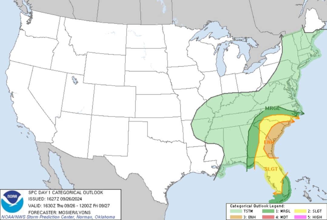
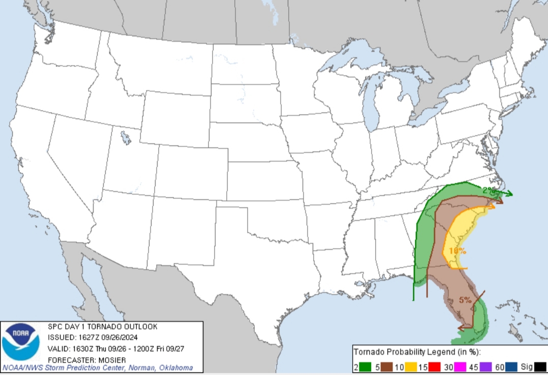
SPC now has a 10% tornado probability within the Enhanced Risk area along the SC and GA coastal areas.
Posted on 9/26/24 at 12:05 pm to MasterAbe1
quote:
Are we expecting a Cat 3 on the next weather update?
Looking at the eye and convection over the last hour, I don’t see how it won’t be a 3 at 2et Advisory
Posted on 9/26/24 at 12:06 pm to Roll Tide Ravens
Me!! GUILTY!!!!

Posted on 9/26/24 at 12:06 pm to Purple Spoon
quote:
They will probably realize at the last minute they fricked up and either get out
With the tropical storm force winds extending out so far, maybe it’ll get nasty enough early enough for them to change their minds and leave before the big show gets there.
Posted on 9/26/24 at 12:06 pm to slackster
Steinhatchee needs to stop hogging all of the hurricanes and share with the rest of the state.

Posted on 9/26/24 at 12:07 pm to Purple Spoon
quote:
somebody will do something risky to bail them out of their own stupidity.
Won't be law enforcement.
For those that stay in those situations, they will tell them to get a permanent marker and write their SS# on their arm/leg so it will help them identify the body.
Posted on 9/26/24 at 12:08 pm to NorthEndZone
Hurricane models are still Cat 4 / High End cat 3 for near landfall
HWRF - 939 mb and 108 kts (125 mph)
HMON - 939 mb and 122 kts (140 mph)
HAFS-A - 946 mb and 108 kts (125 mph)
HAFS-B - 944 mb and 116 kts (135 mph)
Average - 942 mb and 130 mph
HWRF - 939 mb and 108 kts (125 mph)
HMON - 939 mb and 122 kts (140 mph)
HAFS-A - 946 mb and 108 kts (125 mph)
HAFS-B - 944 mb and 116 kts (135 mph)
Average - 942 mb and 130 mph
Posted on 9/26/24 at 12:09 pm to IT_Dawg
I put this together during a severe weather thread a while back. I'll post it again later, or Rummy or Rds can add it to the OP.
Ways to get severe weather warnings practically anywhere in the US:
1. A NOAA weather radio
-This is the best option for any type of weather warning no matter where you are in the country. They have a battery backup and will work even when the power is out or cell towers are down. You can also get portable radios that are similar to two-way radios that you can carry anywhere.
2. Your chosen local weather person on your favorite local news channel
-Any of them worth a damn will be live when there is an active tornado warning, some are live for severe thunderstorms that merit coverage.
3. Radio simulcast of your local news/weather affiliate coverage
-For any major weather events many channels are carried live on a partner radio station.
4. Livestream coverage from the above on Facebook, YouTube, websites, etc.
-Most good weather coverage channels will at least stream their coverage to Facebook or their own website or weather app.
5. News affiliated weather apps
-These will give you both direct warning and coverage of ongoing weather events. You can adjust settings to follow your location and get all pertinent warnings for the area you are in.
6. Following the Xwitter account of the National Weather Service office that is responsible for the area you live in, work in, or are visiting
-You can turn on notifications that will give you every single warning that is issued for your area. It will be sent to you automatically. If you are anywhere in the United States or its territories there is a NWS office that covers the area.
7. Weather Apps
-Some (not all) weather apps for your phone will send out warnings that are catered to the area you are in at the time. If you have cell service, it works.
8. The EAS system on your cell phone
-If you do not turn it off it will work to alert you for tornado warnings and destructive severe thunderstorm warnings.

 Page 153 of 310

Popular
Back to top