- My Forums
- Tiger Rant
- LSU Recruiting
- SEC Rant
- Saints Talk
- Pelicans Talk
- More Sports Board
- Fantasy Sports
- Golf Board
- Soccer Board
- O-T Lounge
- Tech Board
- Home/Garden Board
- Outdoor Board
- Health/Fitness Board
- Movie/TV Board
- Book Board
- Music Board
- Political Talk
- Money Talk
- Fark Board
- Gaming Board
- Travel Board
- Food/Drink Board
- Ticket Exchange
- TD Help Board
Customize My Forums- View All Forums
- Show Left Links
- Topic Sort Options
- Trending Topics
- Recent Topics
- Active Topics
Started By
Message


 0
0

Posted on 2/10/21 at 4:36 pm to Duke
Ok. My wife and daughter are supposed to be up in Fort worth at a gymnastics meet and driving home late Sunday afternoon. Not feeling great about them being on the roads
Posted on 2/10/21 at 4:37 pm to Tiger Ryno
Levi Cowan
@TropicalTidbits
A classic reason why the plains aren't just interesting during the tornado season. Arctic air masses plunge southward east of the Rockies, as the mountains prevent geostrophy from stopping their progress. When moisture glides up and over the arctic surge, nasty things happen.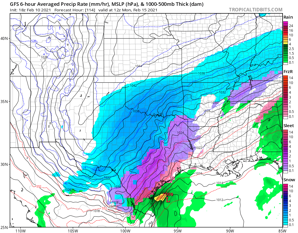

@TropicalTidbits
A classic reason why the plains aren't just interesting during the tornado season. Arctic air masses plunge southward east of the Rockies, as the mountains prevent geostrophy from stopping their progress. When moisture glides up and over the arctic surge, nasty things happen.

Posted on 2/10/21 at 4:46 pm to Duke
My family and I are leaving Baton Rouge area Friday night and headed to Universal in Orlando for a week. Do you think I should empty my electric water heater even though all my pipes outside are covered?

Posted on 2/10/21 at 4:48 pm to sportsaddit68
quote:
My family and I are leaving Baton Rouge area Friday night and headed to Universal in Orlando for a week. Do you think I should empty my electric water heater even though all my pipes outside are covered?
It won't be -27, you'll be fine. May want to head to Punta Cana instead, it might be 35 in Orlando
Posted on 2/10/21 at 4:51 pm to 91TIGER
quote:
May want to head to Punta Cana instead, it might be 35 in Orlando
I'm game for Punta Cana... Unfortunately those resorts don't have Hogwarts. The kids want to do Harry Potter World.
Posted on 2/10/21 at 4:51 pm to lsuman25
Does driving from Fredericksburg, TX back to Laffy on Tuesday seem feasible/safe? Got people going there for the weekend and want to know.
Posted on 2/10/21 at 4:52 pm to sportsaddit68
quote:
Do you think I should empty my electric water heater even though all my pipes outside are covered?
Yeah, do it.
It's like this, if it is a problem, you don't want to come home to a pipe bursting. Do it and you have a minor pain the arse when you get back and have to wait on showers.
Posted on 2/10/21 at 4:54 pm to TDsngumbo
NWS says models are coming into closer agreement in a slight chance of precip overrunning slightly below freezing temperatures with lows in the mid 20s
Should have said models are coming into agreement on a ice storm and frigid temperatures
Still denying, but it's growing on them, just give them time
Should have said models are coming into agreement on a ice storm and frigid temperatures
Still denying, but it's growing on them, just give them time
quote:
126
FXUS64 KLIX 102211
AFDLIX
Area Forecast Discussion
National Weather Service New Orleans LA
411 PM CST Wed Feb 10 2021
.SHORT TERM...Advection fog and low stratus will be the primary
forecast concern tonight into tomorrow morning. Southerly flow
will continue to pump warm and humid air into the region.
Dewpoints will remain very high in the lower 60s which is close to
the prevailing water temperatures just offshore. As the warm and
humid airmass advecting in from the central Gulf moves over these
cooler waters, the airmass will cool to the dewpoint and produce a
bank of dense fog. This fog bank will spread further inland
through the night, and fully expect to see widespread dense fog in
place by daybreak tomorrow. Given this, a dense fog advisory will
take effect at 6 PM and remain in effect through 9 AM tomorrow.
A broad region of positive vorticity advection and upper level
forcing will also remain in place across the area, and a limited
amount of mid-level instability will also exist. These conditions
will support a continued risk of isolated thunderstorm activity
through tomorrow morning.
By tomorrow afternoon, a more well defined upper level vorticity
max and higher omega values will overspread the Gulf South. Mid-
level lapse rates will support elevated convective activity and
a mix of rain and scattered thunderstorms should develop and
persist through tomorrow night. Fortunately, a marine layer in the
low levels will keep surface based convection from forming.
Temperatures will remain well above average through tomorrow
evening.
A front associated with this vort max will push through the area
tomorrow night and then stall over the northern Gulf on Friday. In
the low levels, winds will shift to the north and a shallow pool
of cooler air will advect into the area. Temperatures will fall
below normal with a large temperature gradient in place across the
CWA. Highs will range from the upper 40s in Southwest MS to the
lower 60s along the immediate Louisiana coast, and lows will will
range from the upper 30s to the lower 50s Friday night. Strong
southwest flow will remain in place head of the front, and this
southwest flow will be forced over the cooler and more stable
airmass behind the front throughout Friday and Friday night. This
isentropic forcing will keep skies overcast and rain chances high
with likely to categorical POP in the forecast. Some mid-level
instability will also be in place, and this will allow for
continued convective activity across the southern half of the CWA,
generally south of I-10, through Friday night.
.LONG TERM...The forecast from Saturday through Wednesday has come
into a bit better focus today. All of the global models are
finally ingesting good data on the system moving in from the
west, and this has allowed for much higher continuity between all
of the global models. Thus, forecast confidence has begun to
increase on the overall pattern for the weekend and early next
week.
Initially, another strong southern stream shortwave trough will
slide through the Gulf South over the weekend. A stalled frontal
boundary over the northern Gulf will serve as the focus for a low
pressure system to form over the western Gulf and than transit
through the coastal waters Saturday night into Sunday. Continued
isentropic forcing over the shallow cold pool in the low levels
will keep skies overcast through the period. However, the
strongest upper level forcing will mostly remain over the Gulf of
Mexico. Rain chances should be highest on Saturday as broad
positive vorticity advection and more support jet dynamics allow
for light rain shower activity through the day. Higher instability
values will remain offshore, and this where thunder chances will
be highest Saturday into Saturday. By Sunday, the area of higher
lift will shift to the east and a bit of a mid-level dry slot and
weak upper level subsidence may even begin to work into the area.
This will reduce rain chances to slight chance or less across
most of the forecast area by Sunday morning. The large temperature
gradient will continue with highs ranging from the upper 40s in
Southwest Mississippi to the upper 50s along the coast. Lows will
range from the lower 30s in Southwest Mississippi to the lower 40s
along the coast.
A much stronger shortwave trough will sweep through the forecast
area early next week. This system will bring increased
precipitation chances to the area Monday into Monday night. Most
of the precipitation will fall as rain as temperatures remain
well above freezing Monday into Monday evening. The biggest
question will be timing of the cold air advection into the region
as the precipitation moves out. At this time, have opted to
include a wintry mix of precipitation on the tail end of the
system Monday night. There is less certainty on the exact timing
of the cold air and precipitation, so changes to the forecast are
likely to occur over the coming days. Significant cold air
advection will push lows into the 20s and lower 30s by Tuesday
morning.
The active pattern is likely to continue through Wednesday with
another short wave trough bringing another round of rain to the
area on Wednesday. Fortunately, the heart of the cold pool should
quickly shift to the east with highs warming from the 40s on
Tuesday into the 50s by Wednesday. Lows will remain cool Tuesday
night, but temperatures may bottom out early in the night and then
warm by daybreak as easterly flow brings higher dewpoints into the
region.
This post was edited on 2/10/21 at 4:55 pm
Posted on 2/10/21 at 4:55 pm to Duke
Am playing weather app roulette and seems each chamber is loaded. 4 days of winter precipitation (off/on) and real nasty cold temperatures...5/6 days below freezing
Posted on 2/10/21 at 4:55 pm to 91TIGER
quote:
Punta Cana
Do we get BINGO for winter storm threads?
Posted on 2/10/21 at 5:07 pm to Tiger Ryno
quote:
Colder than the experts think.
:captainamericaiunderstoodthatreference.gif:
Posted on 2/10/21 at 5:09 pm to sportsaddit68
quote:Disney is like totally safe for the kids while you and the wife go on to Punta Cana. No worries, like the pipes, your kids will be fine.
I'm game for Punta Cana... Unfortunately those resorts don't have Hogwarts. The kids want to do Harry Potter World.
Posted on 2/10/21 at 5:10 pm to sportsaddit68
quote:
My family and I are leaving Baton Rouge area Friday night and headed to Universal in Orlando for a week.
I don't care what you people say, BINGO! Bitches.
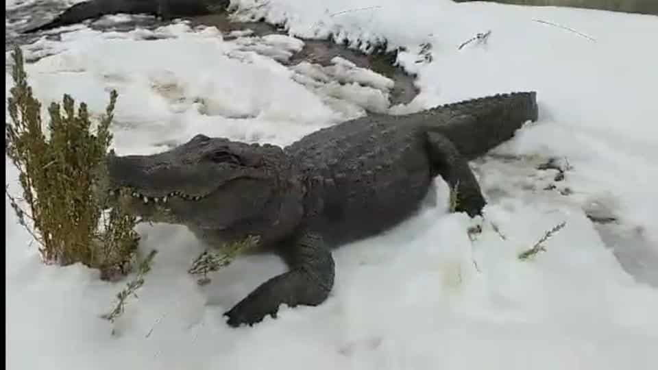
Posted on 2/10/21 at 5:12 pm to jaytothen
A friend just sent me this pic.

Posted on 2/10/21 at 5:17 pm to lsugolfredman
Austin about to get shellacked.
RummelTiger where you at? GL in Gtown
RummelTiger where you at? GL in Gtown
This post was edited on 2/10/21 at 5:25 pm
Posted on 2/10/21 at 5:28 pm to lsugolfredman
you telling me the GFS has shreveport below freezing from Saturday morning through NEXT Friday evening. with 2 different days in the singles

I never should've start messing with these models
I never should've start messing with these models

Posted on 2/10/21 at 5:40 pm to SportTiger1
This event coming to fruition after being in this thread for a week is like seeing your kid grow up and leave for college.
Posted on 2/10/21 at 5:41 pm to DVinBR
Sounds like it will be a nothingburger reading that

Posted on 2/10/21 at 5:44 pm to crazyLSUstudent
quote:
Austin about to get shellacked.
I don't know of any area of Texas that's prepared for what may happen. The ice is one thing, the frigid temps with numbing wind chill numbers will wreak havoc on electricity, pipes, autos, people and livestock. Saw a local WX forecast for OKC calling for blizzard like conditions with 3 ft drifts.

 Page 67 of 284

Popular
Back to top