- My Forums
- Tiger Rant
- LSU Recruiting
- SEC Rant
- Saints Talk
- Pelicans Talk
- More Sports Board
- Fantasy Sports
- Golf Board
- Soccer Board
- O-T Lounge
- Tech Board
- Home/Garden Board
- Outdoor Board
- Health/Fitness Board
- Movie/TV Board
- Book Board
- Music Board
- Political Talk
- Money Talk
- Fark Board
- Gaming Board
- Travel Board
- Food/Drink Board
- Ticket Exchange
- TD Help Board
Customize My Forums- View All Forums
- Show Left Links
- Topic Sort Options
- Trending Topics
- Recent Topics
- Active Topics
Started By
Message
re: Hurricane/Tropical Storm Idalia Discussion Thread
Posted on 8/27/23 at 11:02 pm to ned nederlander
Posted on 8/27/23 at 11:02 pm to ned nederlander
Can they salvage the gas or diesel from the Citgo mixtures?
 0
0

Posted on 8/27/23 at 11:06 pm to NorthEndZone
Just a wobble and a RI from being the worst-case scenario for Tampa. They’ve dodged one for a long time!
Posted on 8/27/23 at 11:08 pm to RockChalkTiger
Saw some cones that it shifted west today? The op hasn’t updated since this morning

Posted on 8/27/23 at 11:08 pm to Nitrogen
Tampa folks still feel like they have an invincibility shield. Let’s see if anyone’s learned from Ian. Tomorrow they have to prepare.
Posted on 8/27/23 at 11:08 pm to RockChalkTiger
What do y’all think the impacts will be to coastal South Carolina? Like the Kiawah area? Supposed to be up there Wednesday to Sunday.
Posted on 8/27/23 at 11:12 pm to RockChalkTiger
quote:
Just a wobble and a RI from being the worst-case scenario for Tampa. They’ve dodged one for a long time!
If it hits a major metro area as a cat 3 or higher, I don’t think there will be any insurance companies writing any more coastal wind policies if they survive those losses.
And if it turns in to a surge event, hopefully everyone has flood insurance.
This post was edited on 8/27/23 at 11:16 pm
Posted on 8/27/23 at 11:12 pm to pjk481
quote:
Kiawah area
Shitty Wednesday. Lovely after!
This post was edited on 8/27/23 at 11:21 pm
Posted on 8/27/23 at 11:14 pm to Tarps99
quote:
insurance companies
I have USAA and my premium has tripled in ten years in northern Alabama. If it smacks Tampa, they may go under, with all the active-duty and retired military there. Michael & Tyndall hit them a pretty good lick!
Posted on 8/27/23 at 11:20 pm to RockChalkTiger
quote:
it should be stressed that additional strengthening to major hurricane strength is becoming increasingly likely before Idalia reaches the Gulf coast of Florida.

Posted on 8/27/23 at 11:23 pm to SmackDaniels
quote:
Saw some cones that it shifted west today? The op hasn’t updated since this morning
The OP updates automatically with each updated NHC track. That one updated at 10pm.
This post was edited on 8/27/23 at 11:24 pm
Posted on 8/27/23 at 11:24 pm to Tarps99
quote:
insurance companies
Louisiana and Florida can become Eskimo brothers.
Maybe Eskimo sisters, because both states have been fricked hard and put up wet when it comes to home owners insurance.
This post was edited on 8/27/23 at 11:29 pm

Posted on 8/27/23 at 11:26 pm to SmackDaniels
quote:
The op hasn’t updated since this morning
lulz…
Posted on 8/27/23 at 11:33 pm to RummelTiger
Probably going to stay up for a bit of the 00z runs.

Posted on 8/27/23 at 11:36 pm to Duke
Will Tampa Bay's good fortune continue?
Posted on 8/28/23 at 12:08 am to Jwho77
quote:
Tampa Bay's good fortune
Nothing lasts forever.
For those keeping score at home:
2016-Baton Rouge floods—tropical depression
2017-Harvey
2018-Michael
2019-Imelda
2020-Laura
2021-Ida
2022-Ian
2023-?
Somewhere on the Gulf Coast.
Every. fricking. Year.
Posted on 8/28/23 at 12:34 am to Jim Rockford
Been a lot of severe storms associated around the heat dome breaking down the past week. I even got rain yesterday that hailed on me for 30 minutes.
That's actually the bad thing about the massive heat dome breaking down is it's giving energy to make the storms stronger around it.
That's actually the bad thing about the massive heat dome breaking down is it's giving energy to make the storms stronger around it.
This post was edited on 8/28/23 at 12:36 am
Posted on 8/28/23 at 1:17 am to deuce985
If I read the latest GFS run right looks like Tampa might be spared a direct hit right now.
957 MB at landfall - Cat 3.
It'll be further further up the coast. Closer to Big Bend.
957 MB at landfall - Cat 3.
It'll be further further up the coast. Closer to Big Bend.
This post was edited on 8/28/23 at 1:19 am
Posted on 8/28/23 at 3:21 am to jfan244888
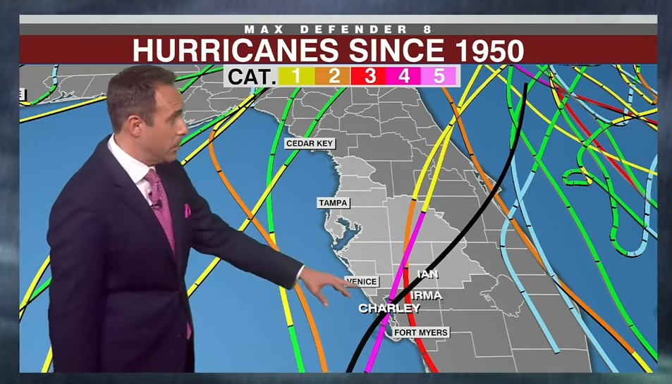
Right now the path is showing the eye 60-70 miles west of Tampa as a cat 2. They have said for years that this would put 14' of water in downtown Tampa. It is still showing just above Cedar Key for landfall, as a cat 2.

This post was edited on 8/28/23 at 3:24 am
Posted on 8/28/23 at 3:38 am to Hangit
All things considered, geography, storm trajectory, etc. Tampa might play hell with it just skirting by.
Posted on 8/28/23 at 4:03 am to Capt ST
Looking like a cat 3 projection now

 Page 65 of 139

Popular
Back to top