- My Forums
- Tiger Rant
- LSU Recruiting
- SEC Rant
- Saints Talk
- Pelicans Talk
- More Sports Board
- Fantasy Sports
- Golf Board
- Soccer Board
- O-T Lounge
- Tech Board
- Home/Garden Board
- Outdoor Board
- Health/Fitness Board
- Movie/TV Board
- Book Board
- Music Board
- Political Talk
- Money Talk
- Fark Board
- Gaming Board
- Travel Board
- Food/Drink Board
- Ticket Exchange
- TD Help Board
Customize My Forums- View All Forums
- Show Left Links
- Topic Sort Options
- Trending Topics
- Recent Topics
- Active Topics
Started By
Message
re: Hurricane/Tropical Storm Idalia Discussion Thread
Posted on 8/28/23 at 4:07 am to Tvilletiger
Posted on 8/28/23 at 4:07 am to Tvilletiger
FORECAST POSITIONS AND MAX WINDS
INIT 28/0900Z 20.1N 85.2W 55 KT 65 MPH
12H 28/1800Z 21.1N 85.1W 65 KT 75 MPH
24H 29/0600Z 22.6N 85.1W 70 KT 80 MPH
36H 29/1800Z 24.8N 84.8W 85 KT 100 MPH
48H 30/0600Z 27.7N 84.0W 100 KT 115 MPH
60H 30/1800Z 30.7N 82.1W 65 KT 75 MPH...INLAND
72H 31/0600Z 32.8N 79.0W 55 KT 65 MPH...OVER WATER
96H 01/0600Z 34.5N 72.0W 50 KT 60 MPH
120H 02/0600Z 34.5N 67.0W 50 KT 60 MPH
$$
Forecaster Blake
 2
2

Posted on 8/28/23 at 4:09 am to lsuman25
*yawns*
Infants and their needs at 3 am.
*yawn*
NHC explicitly calling for a major now.
Infants and their needs at 3 am.
*yawn*
NHC explicitly calling for a major now.
Posted on 8/28/23 at 4:11 am to Duke
quote:
NHC explicitly calling for a major now.
115, with 140 gusts.

Posted on 8/28/23 at 4:12 am to Tvilletiger
Yessir thanks to florida taking the blunt of the storm and giving us some rain.
Posted on 8/28/23 at 4:19 am to lsuman25
Setting up to be a worst case scenario for Tampa/StPete
Cat 4 coming in just north of them will give that area peak storm surge with onshore winds. I’d be evacuating if I lived there. I’m in Fort Myers and was here last year for Ian. Lost power for 5 days but areas closer to the coast were out for 2+ weeks. Any surge over 10-12 feet will wipe out all 1st floor beach front property. It’s better to leave before than ride it out.
Cat 4 coming in just north of them will give that area peak storm surge with onshore winds. I’d be evacuating if I lived there. I’m in Fort Myers and was here last year for Ian. Lost power for 5 days but areas closer to the coast were out for 2+ weeks. Any surge over 10-12 feet will wipe out all 1st floor beach front property. It’s better to leave before than ride it out.

Posted on 8/28/23 at 4:21 am to McGruff21
Hopefully everyone is charging up their Teslas now.

Posted on 8/28/23 at 4:24 am to adam2000
quote:Put down the pots, Florida.
Yessir thanks to florida taking the blunt of the storm and giving us some rain.

Posted on 8/28/23 at 4:37 am to soccerfüt
Hurricane season is the worst. Tampa is waking up for work work and school Monday morning to a fat M in 48 hours.
Also - schools in the south really need to start after Labor Day and run into June. You’d avoid a lot of end of august storm closures
Also - schools in the south really need to start after Labor Day and run into June. You’d avoid a lot of end of august storm closures

Posted on 8/28/23 at 4:48 am to McGruff21
I live on the water in Tampa

This post was edited on 8/28/23 at 4:52 am
Posted on 8/28/23 at 4:54 am to Hangit
Most models showing a high-end 2 at Cedar Key. But they might be underestimating the RI, b/c we’ve never had these SSTs in the historical data. This will be like Ida, watching the dropsondes all night Tuesday and waiting for it to do what everyone expects it to. But the onshore flow is going to fill Tampa Bay and then push it right into downtown as it passes. If I was anywhere below 15’ in Tampa/St. Pete, I’d be leaving. MacDill AFB will have to be evacuated. 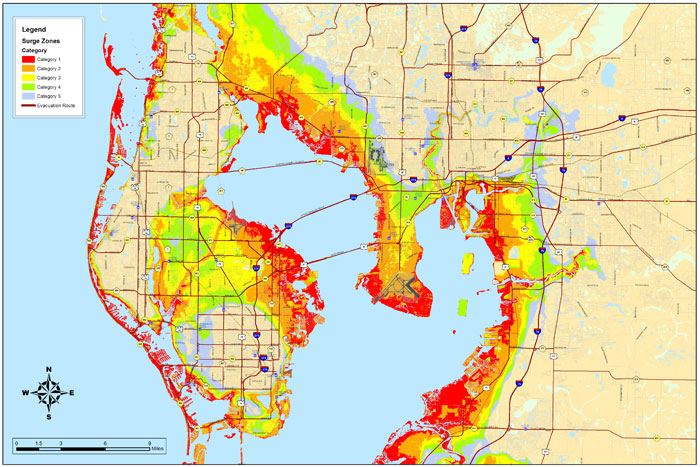
This post was edited on 8/28/23 at 4:56 am
Posted on 8/28/23 at 5:05 am to RockChalkTiger
Local news is calling for 5-7' of surge. They have not updated that to the new, expected cat 3 status. The maps are showing it as a 2 when it goes by Tampa.
This post was edited on 8/28/23 at 5:06 am

Posted on 8/28/23 at 5:10 am to ned nederlander
quote:
Also - schools in the south really need to start after Labor Day and run into June. You’d avoid a lot of end of august storm closures
I have been saying this for years too. To be safe, start school in October and end right before the 4th of July holiday.
Posted on 8/28/23 at 5:13 am to TheOcean
quote:
I live on the water in Tampa
I don't remember which storm, but I remember finding a gas station, with gas, for you, when most were out and the intestate was backed up 150 miles, with folks running out, while sitting in traffic.
Good times...
Posted on 8/28/23 at 5:21 am to Hangit
quote:
Local news is calling for 5-7' of surge.
That's what the NHC is saying, but that's on the current track. Ask the folks in Ft. Myers what happens when it shifts to the right at the last minute. I wouldn't be willing to risk my life on it staying on the black line.

Posted on 8/28/23 at 5:33 am to rds dc
More bursts of convection overnight.

Posted on 8/28/23 at 5:34 am to RockChalkTiger
Hopefully, some of those coastal properties are elevated.
It looked pretty bad in Fort Meyers with an open canal system allowing water to come in from the gulf, areas were dredged for the canals and homes were built on the spoil just an few feet above the gulf water level.
I suspect Tampa has a similar setup.
Ian also brought terrible inland flooding just with rain.
Posted on 8/28/23 at 6:14 am to Tarps99
What shitty updates to wake up to. 48 hours is not a lot of time at all. fricking Yucatan storms.
Posted on 8/28/23 at 6:21 am to Classy Doge
It. Never. Fails. I see that dreaded letter "M" over Ida Lia's path when it's over the open Gulf before landfall. It's gonna be a rough ride for whomever gets hit
Posted on 8/28/23 at 6:23 am to Bobby OG Johnson
Of course it'll be a major hurricane. The Gulf is a jacuzzi this year

 Page 66 of 139

Popular
Back to top