- My Forums
- Tiger Rant
- LSU Recruiting
- SEC Rant
- Saints Talk
- Pelicans Talk
- More Sports Board
- Fantasy Sports
- Golf Board
- Soccer Board
- O-T Lounge
- Tech Board
- Home/Garden Board
- Outdoor Board
- Health/Fitness Board
- Movie/TV Board
- Book Board
- Music Board
- Political Talk
- Money Talk
- Fark Board
- Gaming Board
- Travel Board
- Food/Drink Board
- Ticket Exchange
- TD Help Board
Customize My Forums- View All Forums
- Show Left Links
- Topic Sort Options
- Trending Topics
- Recent Topics
- Active Topics
Started By
Message
re: SoCal Atmospheric River
Posted on 2/2/24 at 2:45 am to trussthetruzz

Posted on 2/2/24 at 2:45 am to trussthetruzz
I prefer the term “pineapple express” over atmospheric river. 
It’s not stopped raining for hours so far up here in SD but I like it. Reminds me of New Orleans.
It’s not stopped raining for hours so far up here in SD but I like it. Reminds me of New Orleans.
 0
0

Posted on 2/2/24 at 5:40 am to BigPerm30
I’d prefer they start there and not ruin the rest of the country

Posted on 2/2/24 at 5:56 am to trussthetruzz
Free Swimming Lessons in Compton
Posted on 2/2/24 at 6:16 am to trussthetruzz
quote:
7 inches of rain over 3 days is a nothingburger in the south but in California it is a huge deal. Yall cant deal with the rain,
wet conditions aren't the problem. Southern California is almost entirely valleys and deserts.... those in the mountainous areas will get mudslides and those in the low areas will get flooding.
Posted on 2/2/24 at 6:25 am to trussthetruzz
My colleague said all the houses around her in Baldwin Hills have been dropping off the cliff. Bad times ahead for lady homie.
Posted on 2/2/24 at 6:53 am to trussthetruzz
The global warming talk will be off the charts.
Posted on 2/2/24 at 11:21 am to Cajun Tifoso
quote:
Tell his perfect his work party dodging skills, or he will be filing sandbags forever.
Officer in the Marine Corps is a bad thing? Go frick yourself.
Posted on 2/2/24 at 11:36 am to trussthetruzz
the canyon terrain can generate some scary flash flood action
Posted on 2/2/24 at 11:54 am to trussthetruzz
Flash floods in the desert will probably close I10.
Very expensive houses will slide down hills.
Idiots will drive 50mph through 3 feet of standing water.
Insurance rates will SKYROCKET.
Very expensive houses will slide down hills.
Idiots will drive 50mph through 3 feet of standing water.
Insurance rates will SKYROCKET.
Posted on 2/2/24 at 12:30 pm to Buckeye Backer
quote:
Sooooooo…no more drought?
They bitch when it doesn't rain, they bitch when it rains. Perfect progressives, them, always the victim.

Posted on 2/2/24 at 12:32 pm to guzziguy
quote:
Flash floods in the desert will probably close I10.
Very expensive houses will slide down hills.
Idiots will drive 50mph through 3 feet of standing water.
Insurance rates will SKYROCKET.


Posted on 2/2/24 at 3:02 pm to trussthetruzz
The Left coast really needs a way to store some of that water before the next drought.
Posted on 2/2/24 at 3:11 pm to trussthetruzz
quote:
Reading about this sorta makes me chuckle. 7 inches of rain over 3 days is a nothingburger in the south but in California it is a huge deal. Yall cant deal with the rain, similar to how southerners can’t deal with snow and northerners can’t deal with heat.
Yep. Their sandy soils can’t absorb water, and moisture erodes their hillsides causing mudslides.
Posted on 2/2/24 at 3:30 pm to Chucktown_Badger
quote:
They bitch when it doesn't rain, they bitch when it rains.
You just described the OT.
Posted on 2/2/24 at 9:16 pm to LegendInMyMind
The strongest storm to hit California this winter will arrive tomorrow night as a potent atmospheric river and a potential bomb cyclone target the state.
Widespread heavy rain, mountain snow, damaging winds, flooding, and isolated severe thunderstorms will be possible as the storm moves through the state.
SoCal faces the highest threat of severe flooding, with 3-7 inches of rain expected across the coast/valleys and 6-12 inches in the mountains, with isolated amounts of up to 15 inches possible. There is the potential for life-threatening, widespread flooding.
Confidence is also increasing that a potential bomb cyclone could develop off the NorCal coast as a low-pressure system rapidly deepens. This could bring a wide swath of damaging winds across much of the Central Coast and NorCal, resulting in widespread power outages.
NorCal will also see heavy rain, with widespread amounts of 2-4 inches and higher amounts in hills/mountains.
The Sierra will finally see a much-needed major snowstorm, with 3-7 feet of snow expected above 6,000 feet. SoCal's mountains will experience heavy snow, with 2-4 feet expected to fall above 7,000 feet.
The greatest impacts from the storm will occur in NorCal from Saturday night to early Monday morning and in SoCal from Sunday evening to early Tuesday morning.
Stay tuned.

Posted on 2/2/24 at 9:22 pm to trussthetruzz
quote:
7 inches of rain over 3 days is a nothingburger in the south but in California it is a huge deal. Yall cant deal with the rain, similar to how southerners can’t deal with snow and northerners can’t deal with heat.
Spoken like a true flatlander. Those of us who have lived in mountainous and foothill areas understand how water gets concentrated in the valleys because you know gravity and shite.
Posted on 2/2/24 at 11:30 pm to Obtuse1
They just had a M5.5 earthquake damn close to Oklahoma City.
This post was edited on 2/2/24 at 11:31 pm
Posted on 2/3/24 at 1:57 pm to LegendInMyMind
The WPC has introduced an area of High Risk on the Excessive Rainfall Outlook.

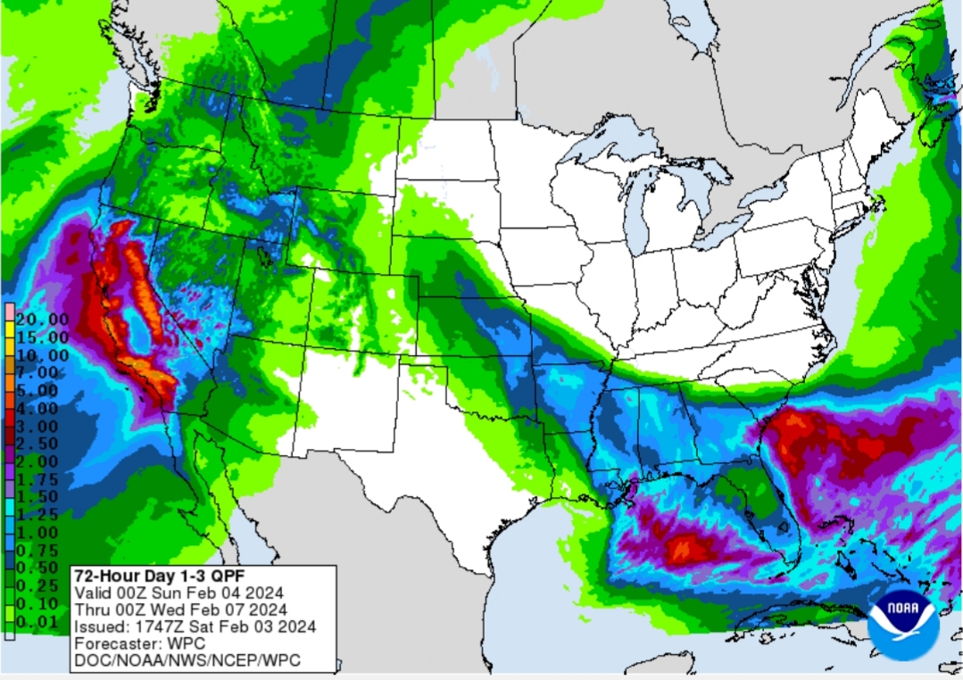
quote:
Excessive Rainfall Discussion NWS Weather Prediction Center College Park MD 154 PM EST Sat Feb 03 2024 Day 2 Valid 12Z Sun Feb 04 2024 - 12Z Mon Feb 05 2024
...THERE IS A HIGH RISK OF EXCESSIVE RAINFALL FOR PORTIONS OF SOUTHERN CALIFORNIA...
...Central to Southern California... The latest models are in good agreement on the evolution of a strengthening cyclone off the central California coast early Sunday as this low pushes northward towards the northern California coast. The strong IVT values that begin to impact the central California coast late day 1, ~1000 kg/m/s, will persist into central California coast range, pushing inland into the northern portions of the San Joaquin Valley and Sacramento Valley and southward into the Transverse Range. Strong inflow and available instability across the area will allow for 1" an hour rain totals, which would be especially problematic where there are burn scars. The probabilities of 8"+ in 24 hours are high enough to introduce a High Risk for portions of the southern CA Transverse ranges. General 3 to 5" areal average amounts likely in both the Transverse and Central California Coast Ranges, with maximum totals just over 10" possible in areas of most persistent training and upslope flow. Modest expansions were made to the Slight and Moderate Risk areas.
For portions of eastern CA near the NV border, including Inyo County/Death Valley, inflow from the Gulf of CA is expected to be more or less unimpeded with 850 hPa winds 40+ kts out of the southeast, setting up a moderate to heavy rain event in the desert. Probabilities of 3"+ in 24 hours is high, particularly in nearby topography where some of the precipitation would be in the form of snow at elevation. The signal was strong/broad enough to lead to some expansion of the Marginal Risk area in that area.

Posted on 2/3/24 at 2:20 pm to LegendInMyMind
Is Riverside/Fontana on the coast yet?

Posted on 2/3/24 at 2:21 pm to Rebel
Depends on whether the big one has hit and formed Arizona Bay yet.

 Page 4 of 10

Popular
Back to top