- My Forums
- Tiger Rant
- LSU Recruiting
- SEC Rant
- Saints Talk
- Pelicans Talk
- More Sports Board
- Fantasy Sports
- Golf Board
- Soccer Board
- O-T Lounge
- Tech Board
- Home/Garden Board
- Outdoor Board
- Health/Fitness Board
- Movie/TV Board
- Book Board
- Music Board
- Political Talk
- Money Talk
- Fark Board
- Gaming Board
- Travel Board
- Food/Drink Board
- Ticket Exchange
- TD Help Board
Customize My Forums- View All Forums
- Show Left Links
- Topic Sort Options
- Trending Topics
- Recent Topics
- Active Topics
Started By
Message
re: Morganza Spillway may or may not open for a 3rd time -- lack of clear info from ACoE
Posted on 3/11/19 at 8:13 pm to JRV
Posted on 3/11/19 at 8:13 pm to JRV
You can approximate it pretty close by river level. About 45' in BR is roughly the flowrate trigger.
It's based on the flow at Red River Landing but I don't remember what that level actually is offhand.
It's based on the flow at Red River Landing but I don't remember what that level actually is offhand.
 1
1

Posted on 3/11/19 at 8:15 pm to Duke
J Grimes said a second crest later in the month could push past 45.
Posted on 3/11/19 at 8:17 pm to JRV
Bonnet Carre opens at 1.25 million. Morganza trigger is 1.5 million cuft/sec.
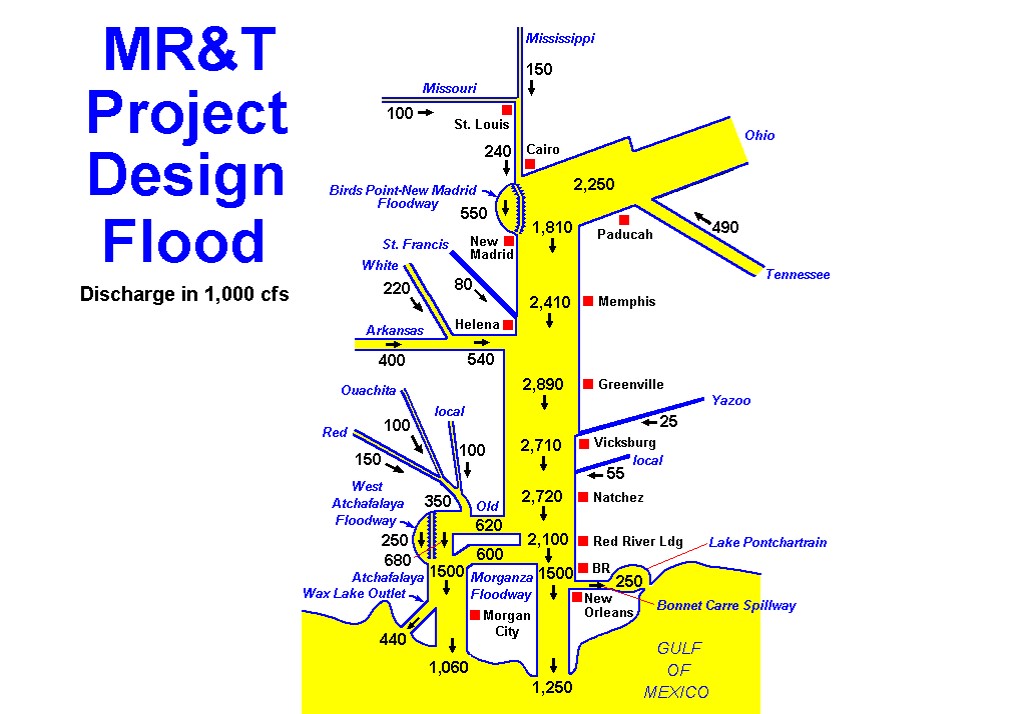
I've seen diagrams that lay out the entire MS River Project and shows trigger flows and estimated current flows, but I can't remember if it was a USACE website.
I've seen diagrams that lay out the entire MS River Project and shows trigger flows and estimated current flows, but I can't remember if it was a USACE website.
Posted on 3/11/19 at 8:25 pm to doubleb
quote:
J Grimes said a second crest later in the month could push past 45.
It's a reasonable position.
Most of the current level is flooding off the Ohio. The snow melt isn't a big player yet. The Iowa snowpack will get rained on by the big storm this week, which leads to a quick melt of a lot of what's on the ground. That's only a piece of the overall snowpack though.
Posted on 3/11/19 at 8:35 pm to Duke
He mentioned an experimental forecasting tool the govt. was using as the basis for his statement. It goes further out than the two week tool based on two days of rainfall.
Posted on 3/11/19 at 8:43 pm to doubleb
Hes referencing a tool that uses a 14-16 day (can't remember exact # of days) rainfall forecasts. A lot of uncertainty cooked in at that range but better than ignoring potential rainfall for the long range planning.
Posted on 3/11/19 at 8:46 pm to Duke
Another hypothetical: prolonged spring high water coupled with a rare early season tropical system...
Posted on 3/11/19 at 8:48 pm to Jim Rockford
quote:
Another hypothetical: prolonged spring high water coupled with a rare early season tropical system...
Thanks for the nightmare.
Posted on 3/11/19 at 8:49 pm to White Roach
Posted on 3/11/19 at 8:51 pm to FutureMikeVIII
Thanks! That's what I was talking about about.
Edit: Actually, after looking closer, your diagram lays out all of the design flows. I've seen another that shows the lower MS valley with design flows and current flows.
Edit: Actually, after looking closer, your diagram lays out all of the design flows. I've seen another that shows the lower MS valley with design flows and current flows.
This post was edited on 3/11/19 at 8:56 pm
Posted on 3/11/19 at 8:53 pm to Jim Rockford
quote:
Another hypothetical: prolonged spring high water coupled with a rare early season tropical system...
Depends on where it drops the rain.
A really early TS is going to be sheared to shite and not able to grab a ton of water. Worst case you're enhancing rainfall upstream.
Posted on 3/11/19 at 9:07 pm to White Roach
quote:
Actually, after looking closer, your diagram lays out all of the design flows. I've seen another that shows the lower MS valley with design flows and current flows.
I’ve never seen that, sounds awesome. The flow at Vicksburg today was ~1,900,000 cfs. In BR, 1,360,000 cfs.
Posted on 3/11/19 at 9:34 pm to Jim Rockford
quote:
Another hypothetical: prolonged spring high water coupled with a rare early season tropical system...
Thanks for the movie idea.
Posted on 3/11/19 at 10:17 pm to Jim Rockford
quote:
Another hypothetical: prolonged spring high water coupled with a rare early season tropical system...
We got about 15" of rain in N. MS over 4 days a couple of weeks ago without a tropical system
Posted on 3/11/19 at 10:27 pm to PipelineBaw
It’s also pretty cool that, on humid mornings, there is dense fog over the spillway area due to the much colder river water coming through.

Posted on 3/11/19 at 10:30 pm to weadjust
That cold river water from the Bonnet Carre having quite an effect on the lake. Drove the causeway yesterday afternoon at around 2:00 and outside temp in my truck was showing 80 before I got on the bridge and dropped as low as 64 by around mile 4-5. Never seen so much fog that late on a warm sunny day
Posted on 3/11/19 at 10:33 pm to TDsngumbo
quote:
Much of what falls in those areas flows into the Mississippi.
Well no shite. The Mississippi drains 2/3 of the United States.
Posted on 3/12/19 at 9:58 am to samson73103
Looks like river forecast holding at tomorrow crest of 44’ but what is interesting is it appears that after dropping it then starts to level off at 42’ in the 26th. Yesterday’s forecast showed it dropping below major flood stage range.
Posted on 3/12/19 at 12:26 pm to tigeraddict
The forecast that uses the 2 day rainfall estimates will always show the river level dropping after 2 days. The other model uses a 16 day rainfall projection, but that will come with errors as well. Neither projection is very reliable outside of a week.

Posted on 3/12/19 at 12:39 pm to tigeraddict
quote:
Looks like river forecast holding at tomorrow crest of 44’ but what is interesting is it appears that after dropping it then starts to level off at 42’ in the 26th. Yesterday’s forecast showed it dropping below major flood stage range
If it is still 41+ when the snowmelt starts, we could be in some real fricking trouble

 Page 36 of 107

Popular
Back to top