- My Forums
- Tiger Rant
- LSU Recruiting
- SEC Rant
- Saints Talk
- Pelicans Talk
- More Sports Board
- Fantasy Sports
- Golf Board
- Soccer Board
- O-T Lounge
- Tech Board
- Home/Garden Board
- Outdoor Board
- Health/Fitness Board
- Movie/TV Board
- Book Board
- Music Board
- Political Talk
- Money Talk
- Fark Board
- Gaming Board
- Travel Board
- Food/Drink Board
- Ticket Exchange
- TD Help Board
Customize My Forums- View All Forums
- Show Left Links
- Topic Sort Options
- Trending Topics
- Recent Topics
- Active Topics
Started By
Message
re: Morganza Spillway may or may not open for a 3rd time -- lack of clear info from ACoE
Posted on 3/9/19 at 5:25 pm to BeepNode
Posted on 3/9/19 at 5:25 pm to BeepNode
What was a foot higher in 2011? On March 9, 2011 the Mississippi River at BR was 26.83 ft.
There is still a lot of spring left. So we’ve got a primed river, a shite load of snow left to melt, and a wet weather pattern.
There will be more peaks this spring that the levees will have to pass. Hopefully we don’t see a flood that beats 2011, but with our current setup, it’s very possible.
There is still a lot of spring left. So we’ve got a primed river, a shite load of snow left to melt, and a wet weather pattern.
There will be more peaks this spring that the levees will have to pass. Hopefully we don’t see a flood that beats 2011, but with our current setup, it’s very possible.
 1
1

Posted on 3/9/19 at 5:36 pm to FutureMikeVIII
Yep. And 2011 was easy to mitigate because the ground was dry. I just wanted to put some of the nervous energy about this particular crest at ease.
Posted on 3/9/19 at 5:40 pm to TigerstuckinMS
quote:
I don't think that's the Bonnet Carre Spillway structure
Its not Morganza
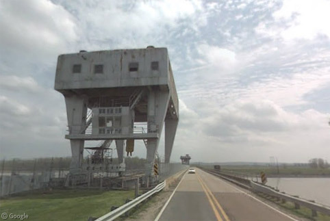
Posted on 3/9/19 at 6:50 pm to NYNolaguy1
That is the Morganza Spillway in your post.
Posted on 3/9/19 at 6:56 pm to Jim Rockford
quote:
This isn't the main crest. That'll be in April or May
So you're saying it will be higher in April/May?
I bet it won't. Might get up to its usual flood stage but none of this exceptionally high shite.

Posted on 3/9/19 at 7:12 pm to Bigfishchoupique
quote:
That is the Morganza Spillway in your post.
The picture in that post is not from the forebay structure. Not sure where it is, but it’s not the forebay.
Posted on 3/9/19 at 7:50 pm to Fratigerguy
You are correct. I am certain now that it is the little over bank structure between the Low Sill Control Structure ( original ORCS ) and the Sidney Murray power plant.
Posted on 3/9/19 at 7:56 pm to Chuker
quote:
So you're saying it will be higher in April/May?
Could be. It's all a timing game. There is a lot of snow to melt in the upper Midwest. It's going to stay cold up there for a couple of more weeks. Once it heats up, a fast melt is going to send a big slug down the river.
Manageable most likely as long as we can break from this wet pattern across Tenn/Ohio/Kentucky by the time the melt really gets going.
Posted on 3/9/19 at 8:14 pm to Duke
quote:
pattern across Tenn/Ohio/Kentucky
so about 15% of the total Ms river drainage plain.

Posted on 3/9/19 at 8:17 pm to Chuker
Someone else is gonna have to keep this thread updated for me. Maybe the admins can. I broke my arm and had to have surgery today and can barely type now. Gonna have to bow out for a while and focus on healing.
Thanks guys.
Thanks guys.
Posted on 3/9/19 at 8:21 pm to TDsngumbo
Sorry, baw.
Posted on 3/9/19 at 8:23 pm to TDsngumbo
quote:Sry to hear. That shite is annoying AF.
TDsngumbo
Hope it wasn't your fap arm.
Posted on 3/9/19 at 8:26 pm to Chuker
quote:
so about 15% of the total Ms river drainage plain.
If it keeps on rainin'....
It's the combo of rain continuing like this over the Ohio valley and the coming snowmelt from the upper Midwest that could well get the river higher than now. We'll see how the river drops into the end of March before getting too worried about that scenario.
Posted on 3/9/19 at 8:50 pm to Duke
Got another big storm system coming mid week and a chance of rain on Monday.
Looks the week after next will be dry though. It’s going to be worrisome with the river this high this early and a lot of wet season to go.
Looks the week after next will be dry though. It’s going to be worrisome with the river this high this early and a lot of wet season to go.
Posted on 3/9/19 at 8:53 pm to Chuker
quote:
so about 15% of the total Ms river drainage plain.
Too bad it accounts for more than 50% the flow to the lower Mississippi. What’s your point?
Posted on 3/9/19 at 11:03 pm to Bigfishchoupique
Yeah I wasn’t sure what it was but it looked a little off for Morganza. Funny thing is, that if you google morganza spillway structure, that picture comes up.
Posted on 3/10/19 at 3:25 am to Fratigerguy
The gantry structures are identical on the Forebay and the Overbank. I’ve driven over them hundreds of times.
Posted on 3/10/19 at 8:13 am to Bigfishchoupique

If you look at the long range forecast for New Madrid, MO, they are looking at breaking 2011 records (when the corps blew up the floodway). Its a ways out, but something to keep an eye on.
Posted on 3/10/19 at 9:04 am to TDsngumbo
quote:
Gonna have to bow out for a while and focus on healing.
Sorry to hear, TD, could you at least post your avatar now and then?
--evil grin---
Posted on 3/10/19 at 11:34 am to foj1981

 Page 34 of 107

Popular
Back to top