- My Forums
- Tiger Rant
- LSU Recruiting
- SEC Rant
- Saints Talk
- Pelicans Talk
- More Sports Board
- Fantasy Sports
- Golf Board
- Soccer Board
- O-T Lounge
- Tech Board
- Home/Garden Board
- Outdoor Board
- Health/Fitness Board
- Movie/TV Board
- Book Board
- Music Board
- Political Talk
- Money Talk
- Fark Board
- Gaming Board
- Travel Board
- Food/Drink Board
- Ticket Exchange
- TD Help Board
Customize My Forums- View All Forums
- Show Left Links
- Topic Sort Options
- Trending Topics
- Recent Topics
- Active Topics
Started By
Message
re: Laura - President Trump visits Lake Charles, Louisiana for Hurricane Response Update
Posted on 8/26/20 at 3:15 pm to SlowFlowPro
Posted on 8/26/20 at 3:15 pm to SlowFlowPro
It’s Steve Mitchell
 1
1


Posted on 8/26/20 at 3:15 pm to Indefatigable
Is Brett Adair the best stream running right now?
Any other good links to stream?
Any other good links to stream?
Posted on 8/26/20 at 3:15 pm to slackster
quote:
I still couldn't convince my inlaws in Crowley and Rayne to come stay with us.
They should be fine as long as they're not on the far south end of Acadia Parish. If they're up near the I-10 part of Crowley and Rayne, they're ok, though likely to lose power from falling limbs.

Posted on 8/26/20 at 3:15 pm to GeauxTigers80
quote:
I’ve always wondered what Peej’s nerdy mug looked like!
he's basically a human chihuahua with an attention complex
Posted on 8/26/20 at 3:16 pm to back9Tiger
quote:
What do the C-130's do in this situation?
Well, that’s pretty self explanatory, but let’s talk about how we got here:
- Texas voted for a Republican Governor
- Louisiana voted for a Democrat Governor
/conversation
Posted on 8/26/20 at 3:16 pm to Bobby OG Johnson
quote:
Philippe Papin
@pppapin
Brief vertical wind shear (VWS) loop last 12h before #Hurricane #Laura's landfall. Guidance is consistent VWS increases quite a bit in the last 6h before impact.
Not enough time for significant weakening Frowning face, but I do not expect RI to continue to the coast like in Michael (2018).
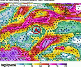
Notice the storms over S. Louisiana (red circle) are going nearly straight up, indicating very low shear. The storms over SE TX (blue circle) have the tops streaking off towards the east, indicating high shear. When does that start impacting the storm? Literally, hours can make a difference here.


Posted on 8/26/20 at 3:16 pm to JasonL79
quote:
Where are you finding those Cameron pics at? I work very close to that pic.
Twitter.

Posted on 8/26/20 at 3:16 pm to nugget
i may be thinking of the wrong area of town
since high school my SLC geography brain has gone downhill
since high school my SLC geography brain has gone downhill
Posted on 8/26/20 at 3:16 pm to rds dc
945.4 MB and dropping in the eye
Posted on 8/26/20 at 3:16 pm to GEAUXmedic
Posted on 8/26/20 at 3:17 pm to Bobby OG Johnson
So I’m currently deployed, but my family is at Ft. Polk. I’m completely ignorant when it comes to hurricanes. I’m keeping up with the latest posts from Vernon Parish and Ft. Polk authorities, but I know y’all are pretty smart about this kind of stuff. Should I tell my wife to take our daughters to her Mom’s house in Arkansas or will they be fine?

Posted on 8/26/20 at 3:17 pm to Klark Kent
Brett Adair

Posted on 8/26/20 at 3:17 pm to GeauxTigers80
that's not Peej... that's the weather guy from LC evacuating to BR
this is Peej posted up in his weather station

this is Peej posted up in his weather station

Posted on 8/26/20 at 3:17 pm to BradC
quote:
945.4 MB and dropping in the eye
Faackkk

Posted on 8/26/20 at 3:18 pm to rds dc
quote:
Notice the storms over S. Louisiana (red circle) are going nearly straight up, indicating very low shear. The storms over SE TX (blue circle) have the tops streaking off towards the east, indicating high shear. When does that start impacting the storm? Literally, hours can make a difference here.
Wait... What? We ask you questions

Posted on 8/26/20 at 3:18 pm to Sao
quote:
Stout, where are these guys at in LC??
LINK
Is a link on the live video thread
LDL casino and Golden Nugget beach area
Posted on 8/26/20 at 3:18 pm to SlowFlowPro
I’m assuming he’s talking about that new house. I thought Dr. Archer lived in Kingspoint for some reason
Posted on 8/26/20 at 3:19 pm to ArmyHogs
If it were my wife and kids, they'd be long gone.
Posted on 8/26/20 at 3:19 pm to rds dc
quote:
Notice the storms over S. Louisiana (red circle) are going nearly straight up, indicating very low shear. The storms over SE TX (blue circle) have the tops streaking off towards the east, indicating high shear.
Great explanation and graphic, now I understand shear

Posted on 8/26/20 at 3:19 pm to ArmyHogs
Fort Polk is going to get rocked but the only risk of injury would be from falling trees. If there's no trees around they're fine.

 Page 517 of 815

Popular
Back to top