- My Forums
- Tiger Rant
- LSU Recruiting
- SEC Rant
- Saints Talk
- Pelicans Talk
- More Sports Board
- Fantasy Sports
- Golf Board
- Soccer Board
- O-T Lounge
- Tech Board
- Home/Garden Board
- Outdoor Board
- Health/Fitness Board
- Movie/TV Board
- Book Board
- Music Board
- Political Talk
- Money Talk
- Fark Board
- Gaming Board
- Travel Board
- Food/Drink Board
- Ticket Exchange
- TD Help Board
Customize My Forums- View All Forums
- Show Left Links
- Topic Sort Options
- Trending Topics
- Recent Topics
- Active Topics
Started By
Message
re: Hurricane Season - Name Wasters Everywhere and then Some Calm to Start July
Posted on 6/23/22 at 6:01 pm to Oates Mustache

Posted on 6/23/22 at 6:01 pm to Oates Mustache
Latest GFS looks like damn September rather than June. shite my arse.
 2
2

Posted on 6/23/22 at 6:46 pm to Oates Mustache
ZCZC MIATWOAT ALL
TTAA00 KNHC DDHHMM
Tropical Weather Outlook
NWS National Hurricane Center Miami FL
800 PM EDT Thu Jun 23 2022
For the North Atlantic...Caribbean Sea and the Gulf of Mexico:
1. Tropical Atlantic:
A tropical wave located over the eastern tropical Atlantic continues
to produce disorganized showers and thunderstorms. This activity has
become a bit more concentrated this evening, and environmental
conditions appear conducive for additional development over the next
few days. A tropical depression could form by early next week as
this system moves westward at around 15 mph over the tropical
Atlantic.
* Formation chance through 48 hours...low...20 percent.
* Formation chance through 5 days...medium...40 percent.
Forecaster Papin

Posted on 6/23/22 at 6:54 pm to lsuman25


Posted on 6/23/22 at 7:03 pm to rds dc

Posted on 6/23/22 at 7:28 pm to Bobby OG Johnson
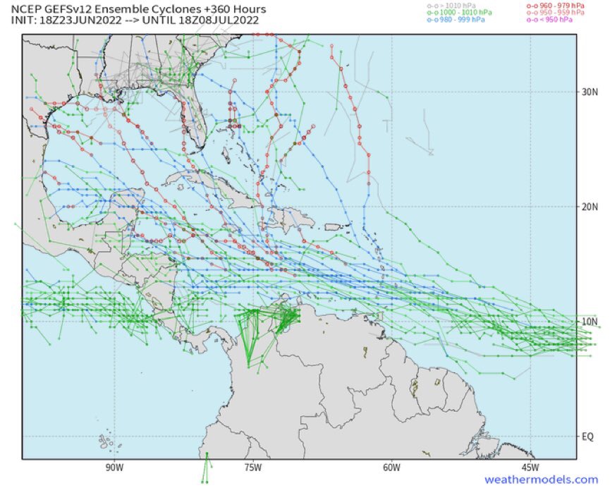
Go look at the GFS ensembles. You guys gonna puke your guts up. 

Posted on 6/23/22 at 7:39 pm to Oates Mustache
quote:
Baw, we don't want no tropical system blowing the rest of your hair off.
Posted on 6/23/22 at 7:40 pm to Oates Mustache
Officially 94L

Break out the shark pics, and titty milk!
Break out the shark pics, and titty milk!
This post was edited on 6/23/22 at 7:42 pm
Posted on 6/23/22 at 8:18 pm to Bobby OG Johnson
Odd to see an early September setup in June

Posted on 6/23/22 at 8:22 pm to deltaland
"Nothing brewing"
2 hrs later
"20%"
2 hrs later"
"40%"

2 hrs later
"20%"
2 hrs later"
"40%"
Posted on 6/23/22 at 8:24 pm to Oates Mustache
quote:
Go look at the GFS ensembles. You guys gonna puke your guts up.

Posted on 6/23/22 at 8:27 pm to pwejr88
quote:quote:
Go look at the GFS ensembles. You guys gonna puke your guts up.
I ain't looking at ensembles for a storm still 2 weeks out
Posted on 6/23/22 at 8:32 pm to rt3
GEFS is pretty well dialed in through day 7. After that the spread is pretty wide with everywhere from Central America to Florida in play.
Posted on 6/23/22 at 8:34 pm to LegendInMyMind

Posted on 6/23/22 at 8:42 pm to pwejr88
Right up the old poop chute, into the GoM. Buckle up, baws, it's getting real, real quick. Oh, and rds, from "marginal" to "oh shite" in a day.
This post was edited on 6/23/22 at 8:43 pm
Posted on 6/23/22 at 9:16 pm to Oates Mustache
quote:
from "marginal" to "oh shite" in a day
quote:
I would fade higher with development chances vs. lower.
However, it is still embedded within the ITCZ and we've seen models be too aggressive with these low running waves in the recent past. On the flip side, the upper air pattern is highly anomalous for June and the system has a lot of moisture with it. Early intensity models are picking up on the low shear, high moisture, high octane path...

Posted on 6/23/22 at 9:17 pm to Oates Mustache
quote:
Go look at the GFS ensembles. You guys gonna puke your guts up.
quote:
Oates Mustache

*Nick needs to watermark his memes
Posted on 6/23/22 at 9:18 pm to Bobby OG Johnson
Posted on 6/23/22 at 9:23 pm to Oates Mustache
So, it could be a factor anywhere from Bermuda to Venezuela? That’s a big chunk of Earth.
Posted on 6/23/22 at 9:24 pm to Oates Mustache
Sometimes the memes just hit at the right time

Posted on 6/23/22 at 9:33 pm to Bobby OG Johnson
What aboot all of that African "Air-dirt" That they said was going to quash everything for June, and possibly into July? Is that still a real thing?
This post was edited on 6/24/22 at 2:12 am

 Page 10 of 16

Popular
Back to top