- My Forums
- Tiger Rant
- LSU Recruiting
- SEC Rant
- Saints Talk
- Pelicans Talk
- More Sports Board
- Fantasy Sports
- Golf Board
- Soccer Board
- O-T Lounge
- Tech Board
- Home/Garden Board
- Outdoor Board
- Health/Fitness Board
- Movie/TV Board
- Book Board
- Music Board
- Political Talk
- Money Talk
- Fark Board
- Gaming Board
- Travel Board
- Food/Drink Board
- Ticket Exchange
- TD Help Board
Customize My Forums- View All Forums
- Show Left Links
- Topic Sort Options
- Trending Topics
- Recent Topics
- Active Topics
Started By
Message
re: Hurricane/Tropical Storm Idalia Discussion Thread
Posted on 8/27/23 at 1:09 pm to Figgy

Posted on 8/27/23 at 1:09 pm to Figgy
quote:FIFY
My wife is getting laid on Davis Island right now and is supposed to catch a flight out of Tampa to Dallas at 2pm on Tuesday. I’m guessing that’s probably going to get delayed. Can someone give me some insight here? Thanks.
tl/dr: She’s cheating on you.
Insight given.
 0
0


Posted on 8/27/23 at 1:15 pm to Figgy
quote:
Can someone give me some insight here? Thanks.
Got a few slow days at work coming up so will try to assist with travel waivers for flights as they pop up. Check the travel board and I'll start a thread likely today or tomorrow

Posted on 8/27/23 at 1:16 pm to Figgy
quote:to the bingo card
and is supposed to catch a flight out of Tampa to Dallas at 2pm on Tuesday. I’m guessing that’s probably going to get delayed. Can someone give me some insight here? Thanks.
Posted on 8/27/23 at 1:19 pm to rds dc
The final chapter / coup de grace will still come similar to Katrina, except a tad bit west. Its simply a matter of time. Hopefully it doesn't happen in our lifetime, but it's coming.
Posted on 8/27/23 at 1:30 pm to Figgy
quote:
My wife is on Davis Island right now and is supposed to catch a flight out of Tampa to Dallas at 2pm on Tuesday. I’m guessing that’s probably going to get delayed. Can someone give me some insight here? Thanks.
She will be at the mercy of whatever the airport decides. It looks to be borderline during that time in the Tampa area.
I use these just to show the arrival time of rougher weather.
HRRR 7AM wind:
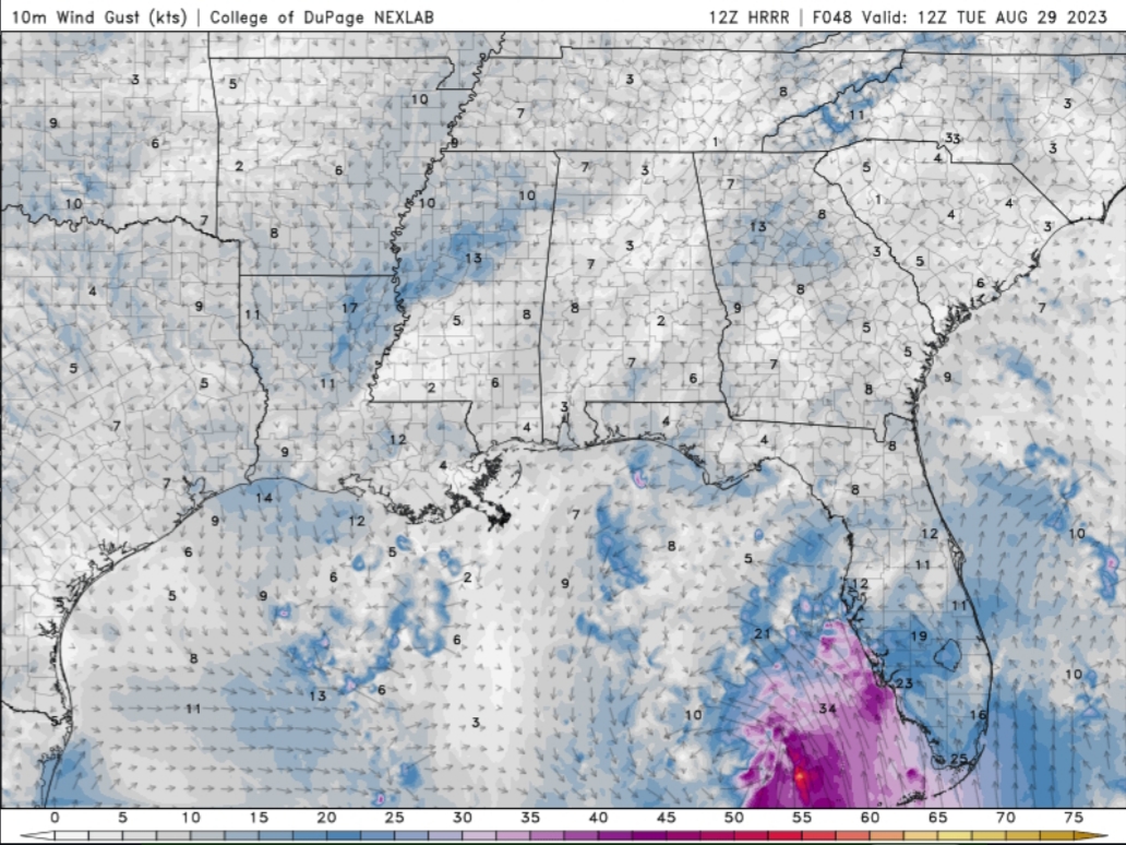
NAM 1PM wind:
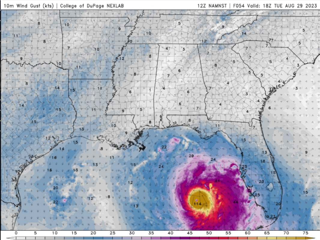
HRRR 7AM Reflectivity:
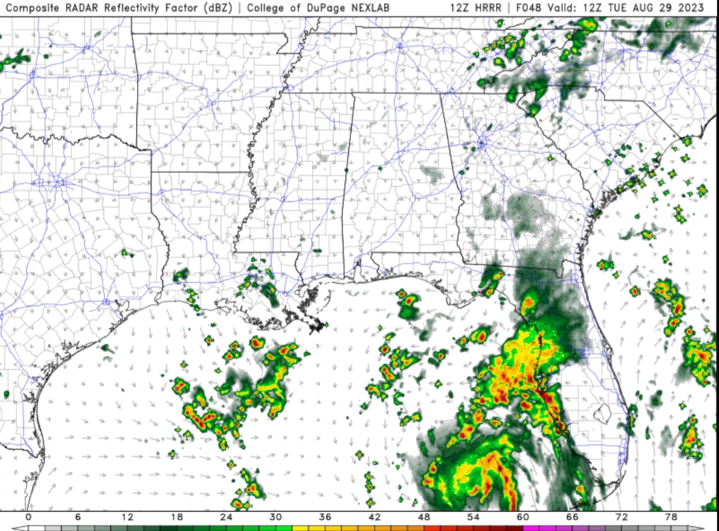
NAM 1PM Reflectivity:
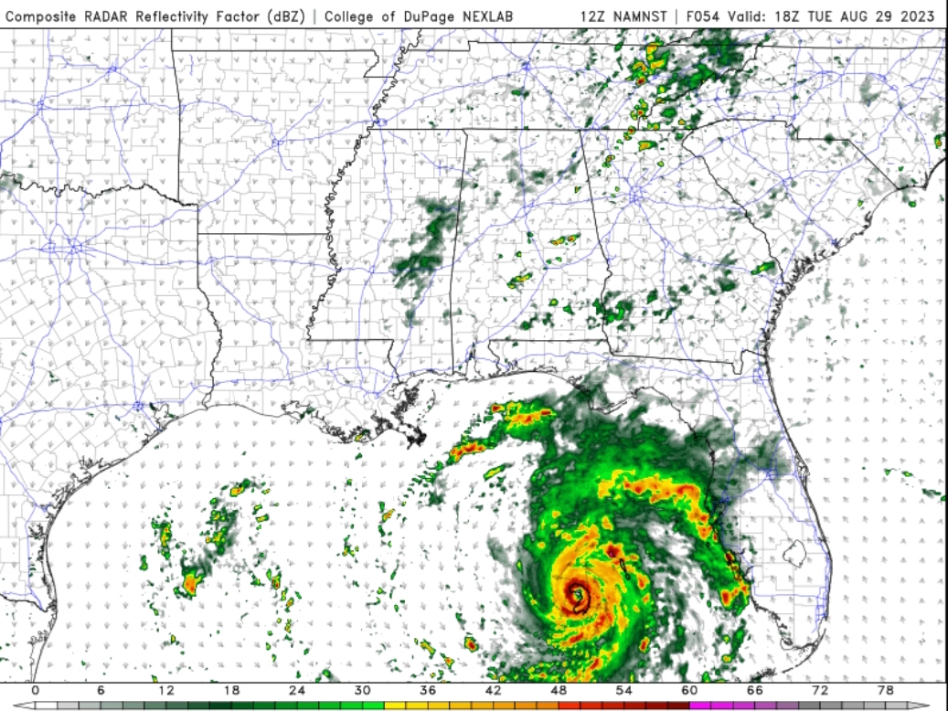
That's as far as as the HRRR is right now. Not hurricane models, but more detailed as far as ballpark conditions than you'll get at this point from hurricane models. And it depends on track, of course, a slight shift east can change things for her timeframe.
Posted on 8/27/23 at 1:49 pm to ChestRockwell
quote:
The final chapter / coup de grace will still come similar to Katrina, except a tad bit west. Its simply a matter of time. Hopefully it doesn't happen in our lifetime, but it's coming.
Ida was pretty close.
She split the uprights between Lafourche and Terrebonne. The saving grace for Ida was that it was not as large of a system as Katrina. Ida was a little more compact and the path helped the bayou communities passing that direction because the winds allowed the water to drain out as the storm approached. Also, so much more levee work has been done, it would take a pretty large surge to flood the Bayou area and the Westbank.
Also, you would be amazed that the river actually acts like a cone forcing more water into the Lake Ponchatrain basin instead of the Barataria or Terrebonne Basin.
A storm forming in the Bay of Campeche or southwestern gulf moving northeast worries me more since we would be in southerly winds for a longer time until center crosses 90 west.
This post was edited on 8/27/23 at 2:05 pm
Posted on 8/27/23 at 2:05 pm to rds dc
Referring to the NWS own definition of one of the requirements for a tropical system to be classified as a tropical storm, look at the colorized satellite loop in the OP and tell me where the "well-defined center of circulation" is in that mess.
There AIN'T one...
WELL-DEFINED...
WELL-DEFI...
WELL-D...
There AIN'T one...
WELL-DEFINED...
WELL-DEFI...
WELL-D...
Posted on 8/27/23 at 2:08 pm to LSURussian
You sure about that? You seem awfully sure about that.
Posted on 8/27/23 at 2:12 pm to LSURussian
The center is well defined, it just lacks a dense core.
Posted on 8/27/23 at 2:41 pm to LSURussian
quote:
Referring to the NWS own definition of one of the requirements for a tropical system to be classified as a tropical storm, look at the colorized satellite loop in the OP and tell me where the "well-defined center of circulation" is in that mess.
We had a plane fly into it, it found surface winds in all directions. Thats a well defined circulation.
Posted on 8/27/23 at 2:47 pm to rds dc
Idalia? Idalia. IDAlia...
It almost sounds like a real name when you repeat it.
It almost sounds like a real name when you repeat it.
Posted on 8/27/23 at 3:29 pm to Tarps99
I have zero confidence in my former "leaders" as to what was improved or what is in the works. Louisiana received a shite load of cash to make improvements from the feds after Katrina. Where exactly did that money go? 17th street canal pumping station , and buying out Sid Mars and shrimp boats? Disagree all you want, but I'm telling you, Louisiana will vote knuckleheads in office that will eventually have to deal with another catastrophic storm. God forbid a hurricane doesn't hit when Teedy is on office. Terrebonne and Lafourche have always flooded.
Posted on 8/27/23 at 3:32 pm to ChestRockwell
quote:
ChestRockwell
Ok
Posted on 8/27/23 at 3:38 pm to LegendInMyMind
quote:I don't see one. Do you?
You sure about that? You seem awfully sure about that.

Posted on 8/27/23 at 3:42 pm to LSURussian
quote:
I don't see one. Do you?
Yes

Posted on 8/27/23 at 3:44 pm to LSUJuice
Nope.
Posted on 8/27/23 at 3:49 pm to LSURussian
Not to sound rude, but do you have anything to add here or is there something else happening with your point that I’m missing?
Posted on 8/27/23 at 3:49 pm to LSURussian
quote:
I don't see one. Do you?
I saw one this morning and it was naked.
Clouds are were over that area an hour ago.
The plane should confirm.
Posted on 8/27/23 at 3:54 pm to LSUJuice
That plane track looks like an old Gibson.

Posted on 8/27/23 at 3:55 pm to LSURussian
quote:
LSURussian
Would you believe me when I tell you its 100% no doubt about it spinning. Ive seen the recon data.
Pressure is under 1000, it aint even a marginal case.

 Page 58 of 139

Popular
Back to top