- My Forums
- Tiger Rant
- LSU Recruiting
- SEC Rant
- Saints Talk
- Pelicans Talk
- More Sports Board
- Fantasy Sports
- Golf Board
- Soccer Board
- O-T Lounge
- Tech Board
- Home/Garden Board
- Outdoor Board
- Health/Fitness Board
- Movie/TV Board
- Book Board
- Music Board
- Political Talk
- Money Talk
- Fark Board
- Gaming Board
- Travel Board
- Food/Drink Board
- Ticket Exchange
- TD Help Board
Customize My Forums- View All Forums
- Show Left Links
- Topic Sort Options
- Trending Topics
- Recent Topics
- Active Topics
Started By
Message
re: Helene - Recovery Begins...Devastating Flash Flooding in Western NC and Eastern TN
Posted on 9/22/24 at 10:15 pm to slackster
Posted on 9/22/24 at 10:15 pm to slackster
quote:
IIRC Michael was spun up in a similar way and they absolutely nailed that forecast from the get go.
Yep. I remember thinking "ah we're fine they never get it right the first forecast"....and then a Cat5 Michael went over our house just as they predicted.
This post was edited on 9/22/24 at 10:24 pm
 1
1

Posted on 9/22/24 at 10:21 pm to tiger91
quote:
What does transient convective feature mean??
Those thunderstorms probably won't last much longer.
Posted on 9/22/24 at 10:25 pm to rds dc
This storm will probably hit Biloxi. These tracks early on have been off my a good bit.
Posted on 9/22/24 at 10:30 pm to rds dc
Looking at the 18z GFS and Euro, there aren't huge differences once this gets in the Gulf. It appears that one of the primary things keeping the Euro in check is that development is slower over the next 48-60 hrs. This might be because the Euro isn't as quick to kill off 10-E, which allows for the outflow from 10-E to disrupt 97L.

Posted on 9/22/24 at 10:32 pm to Roll Tide Ravens
Those anomaly models always make me wonder what they’re seeing. HMNI really has a bone to pick w Disney

Posted on 9/22/24 at 10:37 pm to BZ504
Booooooooo! Boooooooo on you!!!!!
Posted on 9/22/24 at 10:38 pm to rds dc
quote:
Also, the rate at which it is moving eastward is an indication that it probably is a transient convective feature.


Posted on 9/22/24 at 10:44 pm to Meauxjeaux
That one is headed to the OBX/Va. Beach

Posted on 9/22/24 at 10:57 pm to Bobby OG Johnson
Looks to have a lot of undisturbed time to build over the next week.
Posted on 9/22/24 at 11:03 pm to Rhino5
00z GFS doubling down with a landfall near the big bend, southwest of Perry at 942mb
Posted on 9/22/24 at 11:27 pm to SWLA92
It drops the bottom out of the pressure as the storm shoots the gap/dances around Cuba and the Yucatan. It goes from 981mb to 956mb as it threads that needle. Not that it can't happen, but it would take perfect placement to drop 25mb in that area.
Posted on 9/22/24 at 11:33 pm to LegendInMyMind
Yeah talk about bad luck but we’ve seen it happens before. 20 miles one way could make the difference of a cat 1 or a cat 4 unfortunately
Posted on 9/22/24 at 11:48 pm to shell01
quote:
Yep. I remember thinking "ah we're fine they never get it right the first forecast"....and then a Cat5 Michael went over our house just as they predicted.
The problem they had with Michael was the intensity. 5 days out they had it as a moderate Cat1 at most.
Posted on 9/22/24 at 11:55 pm to Roll Tide Ravens
I don't know much about anything but that path looks really bad for Florida because it doesn't seem to have much slowing it down for development and it misses every land interaction possible.
Posted on 9/23/24 at 12:18 am to OvertheDwayneBowe
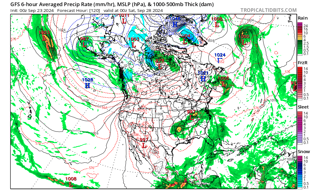
what is this up by alaska?
GFS has a doomcane wiping alaska off the map.
This post was edited on 9/23/24 at 12:21 am
Posted on 9/23/24 at 12:48 am to rds dc
The 00Z Hurricane models are going nuts.
HAFS-B has a 913 MB 139 knot hurricane obliterating Apalachicola.
HAFS-A has a Michael II scenario of 926 MB and 124 knots at Cape San Blas.
HMON has a nearly worst case for Tampa St. Pete with 909 MB and 124 knots near Hernando Beach with a massive surge into Tampa Bay.
HWRF is still running but looks similar.
Hopefully the models are overdoing things, but those are possibilities.
Posted on 9/23/24 at 12:50 am to NorthEndZone
HWRF down to 938 right after it enters the Gulf
Posted on 9/23/24 at 12:52 am to lsuman25
1. Northwestern Caribbean Sea and Gulf of Mexico (AL97):
Showers and thunderstorms are beginning to show signs of
organization with a broad area of low pressure located over the
northwestern Caribbean Sea. Environmental conditions appear
favorable for further development of this system, and a tropical
depression or storm is likely to form over the next couple of days
as the system moves northward across the northwestern Caribbean Sea
and into the southeastern Gulf of Mexico where additional
development is possible.
Regardless of development, this system is expected to produce heavy
rains over portions of Central America during the next several days.
Interests in the northwestern Caribbean, the Yucatan Peninsula of
Mexico, and western Cuba should closely monitor the progress of this
system. Later this week, the system is forecast to move generally
northward across the eastern Gulf of Mexico, and interests along the
northern and northeastern Gulf Coast should also closely monitor
the progress of this system.
* Formation chance through 48 hours...high...70 percent.
* Formation chance through 7 days...high...90 percent.
Posted on 9/23/24 at 2:30 am to friendlyobservation
They have arctic hurricanes up there all the time. That’s not even a bad one.
Posted on 9/23/24 at 3:40 am to NorthEndZone
quote:
The 00Z Hurricane models are going nuts.
They’re making the GFS look conservative and they’re all looking at Thursday landfalls now.
The shite is going to absolutely hit the fan tomorrow. I don’t envy the disaster planning teams in FL right now.
This post was edited on 9/23/24 at 3:44 am

 Page 44 of 310

Popular
Back to top