- My Forums
- Tiger Rant
- LSU Recruiting
- SEC Rant
- Saints Talk
- Pelicans Talk
- More Sports Board
- Fantasy Sports
- Golf Board
- Soccer Board
- O-T Lounge
- Tech Board
- Home/Garden Board
- Outdoor Board
- Health/Fitness Board
- Movie/TV Board
- Book Board
- Music Board
- Political Talk
- Money Talk
- Fark Board
- Gaming Board
- Travel Board
- Food/Drink Board
- Ticket Exchange
- TD Help Board
Customize My Forums- View All Forums
- Show Left Links
- Topic Sort Options
- Trending Topics
- Recent Topics
- Active Topics
Started By
Message
re: Helene - Recovery Begins...Devastating Flash Flooding in Western NC and Eastern TN
Posted on 9/22/24 at 8:52 pm to SlowFlowPro

Posted on 9/22/24 at 8:52 pm to SlowFlowPro
quote:
I think he literally smoked shite and went years without bathing
That guy posts on the Outdoor Board?
 1
1

Posted on 9/22/24 at 8:54 pm to SlowFlowPro
You guys can blame me. Next weekend was the first vacation I've had in a couple years and was bringing the kids to Destin. frick me.

Posted on 9/22/24 at 8:57 pm to RummelTiger
quote:
TBH it was kinda both.
Posted on 9/22/24 at 8:58 pm to SlowFlowPro
quote:
I think he literally smoked shite and went years without bathing
He was really old and in decent health, considering. The villagers all got together and convinced him to bathe. He died three days later.
True story.
This post was edited on 9/22/24 at 8:58 pm
Posted on 9/22/24 at 8:58 pm to toosleaux
quote:
You guys can blame me. Next weekend was the first vacation I've had in a couple years and was bringing the kids to Destin. frick me.
Damn.

Posted on 9/22/24 at 9:00 pm to RummelTiger
Isn’t that Gaston at his kids first college football game?
Need to see the waist size of his jeans to confirm.
Need to see the waist size of his jeans to confirm.

Posted on 9/22/24 at 9:08 pm to Festus
SIAP
Sort of an unusual path for when it moves inland.
Loading Twitter/X Embed...
If tweet fails to load, click here. Sort of an unusual path for when it moves inland.
This post was edited on 9/22/24 at 9:10 pm
Posted on 9/22/24 at 9:17 pm to rds dc
this could be the third hurricane in a year for the big bend region of florida
frick, man
frick, man

Posted on 9/22/24 at 9:19 pm to DVinBR
quote:
this could be the third hurricane in a year for the big bend region of florida
frick, man
Well if you have to pick somewhere along the gulf coast for it to go thats about the best place
Lowest population density anywhere outside of between Brownsville and Corpus

Posted on 9/22/24 at 9:22 pm to Cosmo
quote:
SUNDAY NIGHT NOTES ON INVEST 97L: A hurricane is expected to form over the Gulf of Mexico within the next 72 hours. The name will be Helene (pronounced heh-LEEN).
It remains important to point out that the system has not formed yet. Until we have a well defined low level center, and data from hunter hurricane aircraft (which will be baked into computer models), model output will remain suspect.
It is pretty much impossible to initialize a system that hasn't formed.
Having said that, there is decent agreement with the various ensemble members tonight.
*Highest landfall probabilities are centered around Indian Pass/Cape San Blas/Apalachicola, but the range of possibilities extends from Pensacola over to Cedar Key on the Florida Gulf Coast.
*For now it looks like the Alabama Gulf Coast will be on the drier, west side of the circulation with an offshore flow.
*Intensity guidance suggests Helene could reach category 2 or 3 strength by the time it reaches the coast, most likely Thursday afternoon or Thursday evening. Those along the Florida Gulf Coast from Pensacola to Cedar Key need to be ready for a hurricane (especially from Panama City Beach east through the Big Bend region). A hurricane watch will be issued most likely by Tuesday night or early Wednesday; this is when the area of highest impact will be defined (and over a much smaller area).
*It is still too early for an impact forecast for any specific point along the Gulf Coast, or for any place in Alabama.
*Remember, the main impact in terms of wind, storm surge, and freshwater flooding will be along and to the east of the point of landfall. "East is the beast".
*Guidance from WPC suggests the heaviest rain from Helene will be over Florida, Georgia, and Southeast Alabama. However, with the system expected to jog to the northwest once inland, much of Alabama could see 2-4 inches of rain Wednesday through Friday.
*For now the weather looks decent for the college football games in Alabama Saturday, with just a few lingering, scattered showers around.
Understand any of this could change; be watching for updates. When you are dealing with tropical systems, working with old information is working with bad information.
I will have a detailed video briefing early tomorrow morning here on Facebook, and on my YouTube channel: LINK


Loading Twitter/X Embed...
If tweet fails to load, click here.Posted on 9/22/24 at 9:34 pm to Bobby OG Johnson
Good post.
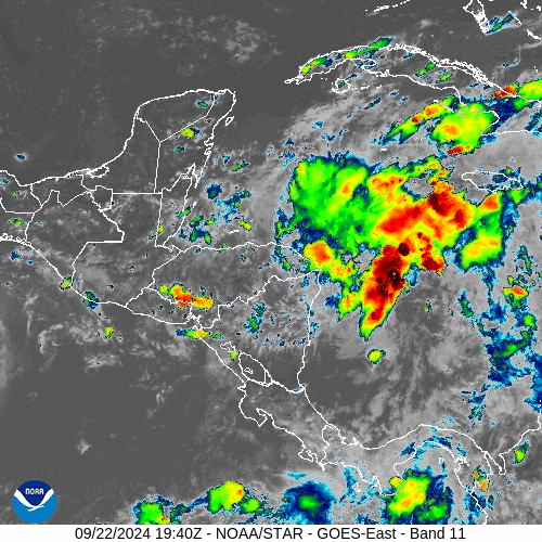
Posted on 9/22/24 at 9:40 pm to slackster
Looking healthy here. May have a TS by morning

Posted on 9/22/24 at 9:42 pm to Roll Tide Ravens
Tight model for not being a storm yet nor really knowing where it may go
Posted on 9/22/24 at 9:44 pm to deltaland
quote:
Looking healthy here. May have a TS by morning
I could be wrong, but I don’t think the center of that convection is the assumed center or the low level circulation. It may pull it underneath itself though.
Posted on 9/22/24 at 9:46 pm to slackster
quote:
I could be wrong, but I don’t think the center of that convection is the assumed center or the low level circulation. It may pull it underneath itself though.
If the center is near that convection then models are initializing way too far SW
Posted on 9/22/24 at 9:55 pm to Cosmo
Cold front gonna kill this thing.
Posted on 9/22/24 at 10:04 pm to Cosmo
So if it’s initializing way too far south west, how does that affect the track? Farther east?
Posted on 9/22/24 at 10:07 pm to deltaland
quote:
Looking healthy here. May have a TS by morning
Can't say for sure without recon, but that convection is well east of where the CIMSS analysis shows the best low level vort. Also, the rate at which it is moving eastward is an indication that it probably is a transient convective feature.
Posted on 9/22/24 at 10:13 pm to rds dc
What does transient convective feature mean??

 Page 43 of 310

Popular
Back to top