- My Forums
- Tiger Rant
- LSU Recruiting
- SEC Rant
- Saints Talk
- Pelicans Talk
- More Sports Board
- Fantasy Sports
- Golf Board
- Soccer Board
- O-T Lounge
- Tech Board
- Home/Garden Board
- Outdoor Board
- Health/Fitness Board
- Movie/TV Board
- Book Board
- Music Board
- Political Talk
- Money Talk
- Fark Board
- Gaming Board
- Travel Board
- Food/Drink Board
- Ticket Exchange
- TD Help Board
Customize My Forums- View All Forums
- Show Left Links
- Topic Sort Options
- Trending Topics
- Recent Topics
- Active Topics
Started By
Message
re: Storm Watch- Gulf- Tropical Depression- Northward Miss. Valley
Posted on 6/2/20 at 12:58 pm to BallsEleven

Posted on 6/2/20 at 12:58 pm to BallsEleven


 0
0

Posted on 6/2/20 at 12:59 pm to tgrbaitn08
Great cone.
ETA: I screenshoted it so we can compare to later cones.
ETA: I screenshoted it so we can compare to later cones.
This post was edited on 6/2/20 at 1:04 pm

Posted on 6/2/20 at 1:05 pm to Geauxnoose
ICON is bullish on strength, track seems about right in line with the TVCN.
My yearly explanation:
The TVCN is what the NHC typically follows, or is very close to.
A lagged average of the last two runs of the members within the TCON plus the ECMWF model is known as the TVCN consensus.
The TCON consensus is the GUNA consensus plus the Hurricane WRF model.
The GUNA model is a consensus of the interpolated versions of the HMON, UKMET with quality control applied to the cyclone tracker, United States Navy NAVGEM, and GFS models.
So the TVCN involves the ECMWF, HWRF, HMON, UKMET, NAVGEM, and GFS.
This post was edited on 6/2/20 at 1:06 pm

Posted on 6/2/20 at 1:12 pm to GEAUXmedic
The Euro is running right now and it'll be interesting to see where and how strong of a landfall it gives it. We can discuss and downplay models all day but the Euro has always performed very well and should never be discounted.
Posted on 6/2/20 at 1:12 pm to GEAUXmedic
The UKM must be run by Falcons fans.
Posted on 6/2/20 at 1:13 pm to TDsngumbo
The water in the northern gulf is a lot cooler this time of the year compared to August and September. Even July. So that could hold it down in strength some.
Posted on 6/2/20 at 1:14 pm to GEAUXmedic
Living in LA I'm glad to see the early models squaring us up. Seems like wherever they initially think it will land always winds up not even being close to actual landfall.
Posted on 6/2/20 at 1:16 pm to The Boat
quote:
The water in the northern gulf is a lot cooler this time of the year compared to August and September. Even July. So that could hold it down in strength some.
True, we're likely not going to be looking down the barrel of a category 3 or higher hurricane here BUT the gulf is still much warmer than normal for this time of year (or at least it has been the last couple months - I admittedly haven't checked that stat in the last few weeks). A category 1 or even low-end 2 is not out of the question if the shear backs off a bit and that's still much stronger than most June storms.
Posted on 6/2/20 at 1:16 pm to slinger1317
quote:
early models squaring us up
well if there's anything we learned in the last few months, its that models are very dependable.
Posted on 6/2/20 at 1:16 pm to slinger1317
Not to neck beard actually you but they pretty much nailed Gustav, Isaac, and Barry days and days out. If Louisiana gets one they’ve been pretty good days out with our last few storms.
Posted on 6/2/20 at 1:17 pm to rt3
Definitely time to sticky now.
Posted on 6/2/20 at 1:19 pm to Fat Fingers
So far the 12z Euro has the center roughly 80-100 miles east on Thursday night from it's previous run at the same time. I'm wondering if it's going to put landfall somewhere between Lake Charles and Lafayette now, assuming everything else falls into place? This run should be interesting to watch.
Edited:
Yep, much further east. Landfall is in Vermilion Bay as a strong cat 1.


Edited:
Yep, much further east. Landfall is in Vermilion Bay as a strong cat 1.
This post was edited on 6/2/20 at 1:31 pm
Posted on 6/2/20 at 1:20 pm to Fat Fingers
quote:
Definitely time to sticky now.
Ewwwwwwwwwwwwwwwwww

Posted on 6/2/20 at 1:25 pm to rt3
Is there any way this does bot end yo hitting New Orleans?
This is 2020 so it is inevitable. Especially considering we are running backup generators 24/7 on pumps because they cannot fix the primary generators.
This is 2020 so it is inevitable. Especially considering we are running backup generators 24/7 on pumps because they cannot fix the primary generators.
Posted on 6/2/20 at 1:25 pm to rt3
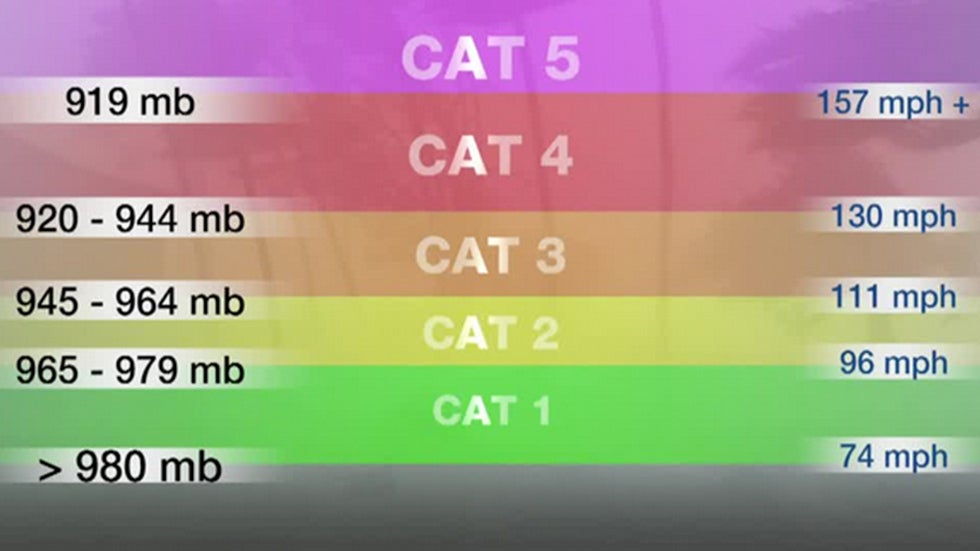
986 mb on High Resolution Euro.
ETA: 979 mb landfall at Morgan City Monday morning
ETA: 979 mb landfall at Morgan City Monday morning
This post was edited on 6/2/20 at 1:30 pm
Posted on 6/2/20 at 1:34 pm to lsugolfredman
How about that mid-west/Canadian blaster going through?

Posted on 6/2/20 at 1:34 pm to lsugolfredman
quote:
ETA: 979 mb landfall at Morgan City Monday morning
May be time to test generators this week if the Euro holds that for the next couple days.
The Destroya is gonna love all the attention.
This post was edited on 6/2/20 at 1:36 pm
Posted on 6/2/20 at 1:35 pm to TheWiz
quote:
How about that mid-west/Canadian blaster going through?
I believe that is part of the reason for the sharp increase in speed northward.
Posted on 6/2/20 at 1:37 pm to lsugolfredman
That's after a crawl along the coast. UKMet pulled a similar move, but with what would be Dolly and starting well east of the rest of them. Gets to about the LA coast, turns west slowly and eventually lifts up Morgan Cityish.
Oddly end up very similar despite it being two different systems, but similar pressure and movement.
We got two troughs, one up in New England and a big one out west. Ridge builds in between them. The two models end up slamming the north movement down as the ridge builds in, slide west slowly under it, and then catches an opening as the western trough progresses east.

Posted on 6/2/20 at 1:39 pm to BallsEleven
quote:
I'd be surprised if it reaches CAT 1 strength
The way they are all trending a CAT 1 would not be a surprise. A CAT 3 would be a surprise but a 1 or even 2 not so much.

 Page 16 of 107

Popular
Back to top