- My Forums
- Tiger Rant
- LSU Recruiting
- SEC Rant
- Saints Talk
- Pelicans Talk
- More Sports Board
- Fantasy Sports
- Golf Board
- Soccer Board
- O-T Lounge
- Tech Board
- Home/Garden Board
- Outdoor Board
- Health/Fitness Board
- Movie/TV Board
- Book Board
- Music Board
- Political Talk
- Money Talk
- Fark Board
- Gaming Board
- Travel Board
- Food/Drink Board
- Ticket Exchange
- TD Help Board
Customize My Forums- View All Forums
- Show Left Links
- Topic Sort Options
- Trending Topics
- Recent Topics
- Active Topics
Started By
Message
re: Storm Watch- Gulf- Tropical Depression- Northward Miss. Valley
Posted on 6/2/20 at 10:54 am to LSUfanNkaty
Posted on 6/2/20 at 10:54 am to LSUfanNkaty
quote:
I put gyre cheese on my sammich last night
I went with cheddar on mine
b/c I'm American
 1
1

Posted on 6/2/20 at 10:55 am to Zephyrius
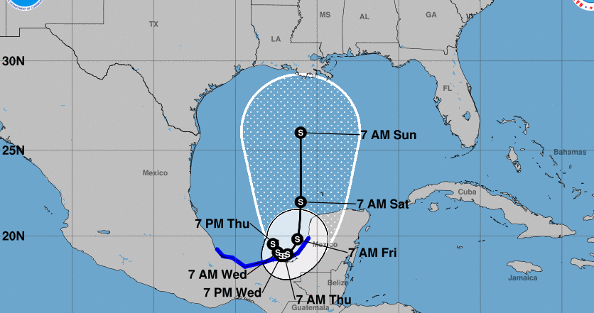
They must expect the storm to race to the Northern gulf coast. Thats an incredible distance in 24hrs

Posted on 6/2/20 at 11:01 am to Mudminnow
quote:
Only 3 named storms forming in June in the satellite era (since 1966) have undergone rapid intensification (RI): Alma (1966), Alison (1995) and Chris (2012). Rapid intensification is typically defined to be >=30 mph strengthening in 24 hrs.
Posted on 6/2/20 at 11:04 am to rds dc
quote:
The BOC is known for quick spin ups and conditions are somewhat favorable in the far southern portion of the BOC. The models are bringing the storm back SW into Mexico over the next few days and that area can quickly disrupt systems. However, if the storm stays out over the BOC before making the turn north than things could really change - see the 12z ICON. It gets really tricky as the outflow from a stronger system might be able to disrupt the upper level trough but a weaker system probably gets sheared by the upper levels as it moves north.
Models have backed off the SW movement somewhat and are now favoring more of a southward drift. Not much will happen over the next couple of days as the storm drifts southward with land interaction playing a big role in what happens later in the week.
EPS and GEFS in pretty good agreement of a slow southward drift in the short range.


Once the storm starts lifting north there will be two troughs to watch with each influencing track. The first one will be exiting the NE as the systems starts going north and that will pull it N/NE and then a second stronger trough will move into the NW and start pulling the system NW or even W. We are still far enough out in time that the timing of those troughs and their overall influence on track is still somewhat uncertain.

Posted on 6/2/20 at 11:05 am to paperwasp
quote:
Only 3 named storms forming in June in the satellite era (since 1966) have undergone rapid intensification (RI): Alma (1966), Alison (1995) and Chris (2012). Rapid intensification is typically defined to be >=30 mph strengthening in 24 hrs.
so you're telling me the very 1st storm of the satellite era underwent RI
pretty good averages there
Posted on 6/2/20 at 11:11 am to rt3
quote:
I went with cheddar on mine b/c I'm American
Cheddar is a British cheese.
Posted on 6/2/20 at 11:37 am to glassman
quote:
Cheddar is a British cheese.
God Save the Queen mfer... and bend the knee you peasant
Posted on 6/2/20 at 11:38 am to rt3
quote:
you peasant
Posted on 6/2/20 at 11:39 am to glassman
Posted on 6/2/20 at 11:40 am to rt3
officially Cristobal
quote:
119
WTNT63 KNHC 021626 CCB
TCUAT3
Tropical Storm Cristobal Tropical Cyclone Update
NWS National Hurricane Center Miami FL AL032020
1115 AM CDT Jun 02 2020
Corrected storm ID in header
...DEPRESSION STRENGTHENS TO A TROPICAL STORM...
Observations from an Air Force Reserve Unit Hurricane Hunter
aircraft indicate that Tropical Depression Three has strengthened
into Tropical Storm Cristobal. The maximum winds are estimated to
be 40 mph (65 km/h) with higher gusts.
SUMMARY OF 1115 AM CDT...1615 UTC...INFORMATION
----------------------------------------------
LOCATION...19.3N 92.7W
ABOUT 150 MI...245 KM WSW OF CAMPECHE MEXICO
ABOUT 135 MI...215 KM NE OF COATZACOALCOS MEXICO
MAXIMUM SUSTAINED WINDS...40 MPH...65 KM/H
PRESENT MOVEMENT...SW OR 230 DEGREES AT 3 MPH...6 KM/H
MINIMUM CENTRAL PRESSURE...1004 MB...29.65 INCHES
$$
Forecaster Pasch
Posted on 6/2/20 at 11:45 am to rt3
Can we just fcking fast forward to 2021 please?
Posted on 6/2/20 at 11:55 am to tgrbaitn08
Oh. Cool.
Posted on 6/2/20 at 11:59 am to PhiTiger1764
Besides it being 2020, there’s nothing really showing it’ll turn into a hurricane before landfall, right? Seems like it’ll just dump a lot of water
Posted on 6/2/20 at 12:01 pm to Large Farva
And every model I’ve seen has it getting out of dodge really quickly once it does make landfall
Posted on 6/2/20 at 12:05 pm to Large Farva
quote:
Besides it being 2020, there’s nothing really showing it’ll turn into a hurricane before landfall, right? Seems like it’ll just dump a lot of water
intensity forecasts are still hit and miss... esp. still this far out
the main thing to watch right now is will it make landfall in Mexico/Central America... and if so how badly do those mountains rip it up before it gets back in the Gulf
obviously it not making landfall would allow it to grow faster and get closer to hurricane strength

Posted on 6/2/20 at 12:43 pm to Large Farva
The official forecast is to reach 65mph in the central gulf so hurricane strength cannot be ruled out.
Posted on 6/2/20 at 12:48 pm to TDsngumbo
OP needs to update title to TS. Also, we need to request a sticky on this thread.
Posted on 6/2/20 at 12:53 pm to Zephyrius
This bares some watching. ICON model showing CAT2 in Abbeville. The model runs tomorrow morning should be more accurate, as it will include the Hurricane Hunter data and the measurement of the surrounding environment.

Posted on 6/2/20 at 12:57 pm to Geauxnoose
I'd be surprised if it reaches CAT 1 strength.
Euro is running now.
Euro is running now.

 Page 15 of 107

Popular
Back to top