- My Forums
- Tiger Rant
- LSU Recruiting
- SEC Rant
- Saints Talk
- Pelicans Talk
- More Sports Board
- Fantasy Sports
- Golf Board
- Soccer Board
- O-T Lounge
- Tech Board
- Home/Garden Board
- Outdoor Board
- Health/Fitness Board
- Movie/TV Board
- Book Board
- Music Board
- Political Talk
- Money Talk
- Fark Board
- Gaming Board
- Travel Board
- Food/Drink Board
- Ticket Exchange
- TD Help Board
Customize My Forums- View All Forums
- Show Left Links
- Topic Sort Options
- Trending Topics
- Recent Topics
- Active Topics
Started By
Message
re: Storm Update:- Ida Moves Away - The Cleanup Begins...
Posted on 8/28/21 at 3:53 pm to Choot em Tiger

Posted on 8/28/21 at 3:53 pm to Choot em Tiger
quote:
If this happened in Covington there would be no Covington.
yep. There wasn’t 160 mph winds in Lake Charles or Cameron/Creole for Laura and those places got plowed with widespread catastrophic damage.
This post was edited on 8/28/21 at 3:54 pm
 0
0


Posted on 8/28/21 at 3:53 pm to slackster
That's the 1pm update
Posted on 8/28/21 at 3:53 pm to IS_IT_GAMEDAY
quote:
Im ready for this update. This will seal our fate im afraid.
Still got a long way to go, but I don't think this update makes anyone in SELA comfortable. It's not going to be a favorable track for ya'll, but it could swing back west later. Who knows.
Posted on 8/28/21 at 3:53 pm to AmosMosesAndTwins
quote:
There are people looking to this thread for information.
Technically his point was centered around lack of information from the government.
Posted on 8/28/21 at 3:53 pm to slackster
4:00 PM CDT Sat Aug 28
Location: 26.2°N 87.0°W
Moving: NW at 16 mph
Min pressure: 976 mb
Max sustained: 105 mph

Ida has moved a little to the right of the previous track, but the
long-term motion motion is still northwestward or 320/14 kt. The
track forecast philosophy remains unchanged. Ida is expected to
continue on a northwestward heading through late Sunday as it is
steered around the southwestern portion of a deep-layer ridge near
the southeastern United Stated coast. After landfall, Ida's forward
motion is forecast to slow when it turns northward around the
western extent of the aforementioned ridge. By Tuesday, the cyclone
should reach the southern extent of the mid-latitude westerlies,
causing it to turn north-northeastward across the Lower Mississippi
and Tennessee Valleys. The track guidance has nudged slightly
eastward during the first 12-24 hours, primarily due to the more
northeastward initial position, and this has required a slight
rightward adjustment in the new official forecast at those times.
The remainder of the NHC forecast is largely unchanged from before,
and lies near various consensus models and the GFS ensemble mean.
Location: 26.2°N 87.0°W
Moving: NW at 16 mph
Min pressure: 976 mb
Max sustained: 105 mph
Ida has moved a little to the right of the previous track, but the
long-term motion motion is still northwestward or 320/14 kt. The
track forecast philosophy remains unchanged. Ida is expected to
continue on a northwestward heading through late Sunday as it is
steered around the southwestern portion of a deep-layer ridge near
the southeastern United Stated coast. After landfall, Ida's forward
motion is forecast to slow when it turns northward around the
western extent of the aforementioned ridge. By Tuesday, the cyclone
should reach the southern extent of the mid-latitude westerlies,
causing it to turn north-northeastward across the Lower Mississippi
and Tennessee Valleys. The track guidance has nudged slightly
eastward during the first 12-24 hours, primarily due to the more
northeastward initial position, and this has required a slight
rightward adjustment in the new official forecast at those times.
The remainder of the NHC forecast is largely unchanged from before,
and lies near various consensus models and the GFS ensemble mean.
This post was edited on 8/28/21 at 3:54 pm
Posted on 8/28/21 at 3:54 pm to geauxtigers87
quote:
That's the 1pm update
It’s not. It will fix itself in a second. The 4pm is out.
Posted on 8/28/21 at 3:54 pm to mightynine
If the H had a red headed count hair it moved that much
Posted on 8/28/21 at 3:54 pm to slackster
Not as east as I was anticiapting. And it will hit here mostly in the daylight. That’s good news.

Posted on 8/28/21 at 3:54 pm to The Boat
quote:
A mandatory evacuation of New Orleans was called 19 hours before Katrina made landfall.
Yeah…Teedy dropped the ball bad on this. JBE should have overridden her dumb arse, but that would be compounding dumbassery.
Posted on 8/28/21 at 3:54 pm to mightynine
:frick:
Posted on 8/28/21 at 3:54 pm to slackster
Slackster is correct - slight shift east to Terrebonne bay but closer to Fourchon
Posted on 8/28/21 at 3:54 pm to slackster
Yikes
Posted on 8/28/21 at 3:54 pm to LegendInMyMind
NAM Simulated Reflectivity that shows the potential for significant banding after the center has left the area:
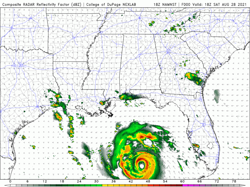
This post was edited on 8/28/21 at 3:57 pm

Posted on 8/28/21 at 3:55 pm to rds dc
Might sound creepy, but, I lost a home to Ike. Been through Rita, Laura, Delta...anything in SWLA in the past 30+ years. If you really need a place to go, I got ya. You will be on a couch or an inflatable mattress, but I got ya. If you are someone who needs to leave and has absolutely nowhere to go, let me know. GTFO there.
Posted on 8/28/21 at 3:55 pm to Swagga
NHC staying with 130mph at landfall.

Posted on 8/28/21 at 3:55 pm to Cajunhawk81
quote:little wobble west is fine with me
No more wobbles
Posted on 8/28/21 at 3:55 pm to slackster
quote:
Then the plan is fricking ridiculous.
They had 60 hours before the storm was to hit.
How does it take 48 hours? Just get state troopers to stop incoming traffic on I-55 and I-10 and let all 4 lanes go out of the city. You could do it in an hour. Announce that the causeway will remain both lanes for anyone needing to get into the city for another 12 hours, let I-10 on the north shore run both ways for this time. 55 is one way till Mississippi. After 12 hours shut down I-10 and make it all one way heading east toward ms from the causeway bridge and one way west to 55 or Baton Rouge from the causeway bridge
This encourages a northern evacuation as well if you open 55 first
This post was edited on 8/28/21 at 4:03 pm
Posted on 8/28/21 at 3:55 pm to slackster
Only 2 hours?!? Way more than that with those crowds

Posted on 8/28/21 at 3:56 pm to slackster


 Page 445 of 1029

Popular
Back to top