




- My Forums
- Tiger Rant
- LSU Recruiting
- SEC Rant
- Saints Talk
- Pelicans Talk
- More Sports Board
- Fantasy Sports
- Golf Board
- Soccer Board
- O-T Lounge
- Tech Board
- Home/Garden Board
- Outdoor Board
- Health/Fitness Board
- Movie/TV Board
- Book Board
- Music Board
- Political Talk
- Money Talk
- Fark Board
- Gaming Board
- Travel Board
- Food/Drink Board
- Ticket Exchange
- TD Help Board
Customize My Forums- View All Forums
- Show Left Links
- Topic Sort Options
- Trending Topics
- Recent Topics
- Active Topics
Started By
Message


 2
2


Posted on 8/26/20 at 11:28 am to bee Rye
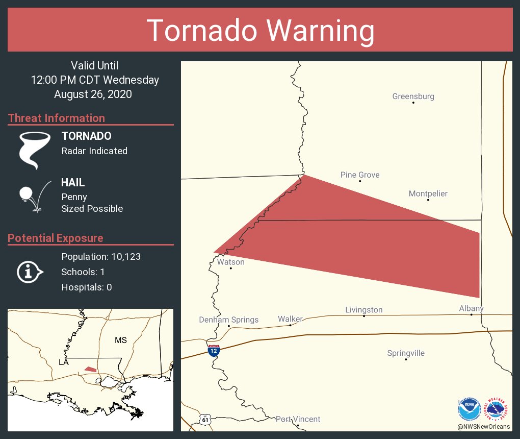
Tornado Warning issued for Northern Livingston Parish
quote:
The National Weather Service in New Orleans has issued a * Tornado Warning for... Southwestern St. Helena Parish in southeastern Louisiana... Northern Livingston Parish in southeastern Louisiana... Eastern East Baton Rouge Parish in southeastern Louisiana... * Until noon CDT. * At 1123 AM CDT, a severe thunderstorm capable of producing a tornado was located near Albany, or 9 miles northwest of Hammond, moving northwest at 30 mph. HAZARD...Tornado. SOURCE...Radar indicated rotation. IMPACT...Flying debris will be dangerous to those caught without shelter. Mobile homes will be damaged or destroyed. Damage to roofs, windows, and vehicles will occur. Tree damage is likely. * This tornadic thunderstorm will remain over mainly rural areas of southwestern St. Helena, northern Livingston and eastern East Baton Rouge Parishes.
This post was edited on 8/26/20 at 11:29 am


Posted on 8/26/20 at 11:28 am to 50_Tiger
quote:
A Shell facility recorded a 160 mph wind gust a bit ago.
So they essentially just got hit with the equivalent of a high EF3 tornado. Goodness.
Posted on 8/26/20 at 11:28 am to Stevo
The state west of I-49 may lose power
Posted on 8/26/20 at 11:29 am to blake243
quote:
The state west of I-49 WILL lose power
Posted on 8/26/20 at 11:29 am to tgrbaitn08
quote:
Cajun Navy
I wish they’d never have named these people. There’s for sure some good people who volunteer their time and resources.
Then there are others who seek to profiteer....some felons I won’t mention by name.

Posted on 8/26/20 at 11:30 am to Stevo
quote:
Opelousas could easily lose power.
do we know if these hotels have backup generators?
Posted on 8/26/20 at 11:31 am to blake243
Emergency crews piling up at the Cajun Dome
Posted on 8/26/20 at 11:31 am to bnb9433
Posted on 8/26/20 at 11:31 am to bee Rye
Have some Airbnbs's in downtown NOLA if any of you guys cant find a place
LSU5508@gmail.com
LSU5508@gmail.com

Posted on 8/26/20 at 11:32 am to El Tigre Grande
quote:
Duke
How wide would you estimate the destructive force winds are?
Not Duke, but the best bet can be found in the NHC 10AM Discussion under "Key Messages".
quote:
2. Hurricane-force winds are expected tonight in portions of the hurricane warning area from San Luis Pass, Texas, to west of Morgan City, Louisiana, with catastrophic wind damage expected where Laura's eyewall makes landfall. Hurricane-force winds and widespread damaging wind gusts will spread well inland across portions of eastern Texas and western Louisiana early Thursday.
NHC Discussion
This post was edited on 8/26/20 at 11:33 am
Posted on 8/26/20 at 11:32 am to ForeverLSU02
quote:
Tornado Warning issued for Northern Livingston Parish
RIP PeeJ
Posted on 8/26/20 at 11:32 am to DLauw
quote:
Have some Airbnbs's in downtown NOLA if any of you guys cant find a place
LSU5508@gmail.com

Posted on 8/26/20 at 11:32 am to El Tigre Grande
quote:
How wide would you estimate the destructive force winds are?

This is the width of the wind field as of now. The major hurricane conditions exist at and close to the center. A good approximation is probably looking at the surge forecast. Area of the highest storm surge is going to be about where the destructive winds extend to.

Posted on 8/26/20 at 11:34 am to Tigerfan1274
quote:
Okay, someone help me out. Rita’s surge was 15’-16’. Ike’s was 20’. Why is this projection so much higher than those with a similar surge projected?
Aren’t Laura’s winds Predicted to be stronger than the other storms?

Posted on 8/26/20 at 11:35 am to OsTiger78
Yeh. New Iberia should be fine. The hotels I’m thinking of are by Lowe’s and chili’s off the abbeville hwy. they probably have vacancies

Posted on 8/26/20 at 11:35 am to threeputtforbogie
quote:
Does anyone have insight into what the plants in LC are doing for the storm?
Yes, I'm in the industry. over 425 plants have shuttered in the path. That is 200 plus chem plants, 200 plus petro plants and the rest misc and power.
That is an absolutely staggering number.
Posted on 8/26/20 at 11:35 am to Tigerfan1274
quote:
Okay, someone help me out. Rita’s surge was 15’-16’. Ike’s was 20’. Why is this projection so much higher than those with a similar surge projected?
Didn't they change how they model/report this a few years ago? Maybe they changed it from above sea level to above ground level?
Maybe someone smarter can chime in.
Posted on 8/26/20 at 11:35 am to LegendInMyMind
quote:
to west of Morgan City
patterson and Berwick can't get no love?
hopefully some of the trees on 6 at Snatch come down
Posted on 8/26/20 at 11:36 am to doubleb
quote:
Aren’t Laura’s winds Predicted to be stronger than the other storms?
Quite a bit. I was speaking just about surge.

 Page 468 of 815

Popular
Back to top
 Follow TigerDroppings for LSU Football News