- My Forums
- Tiger Rant
- LSU Recruiting
- SEC Rant
- Saints Talk
- Pelicans Talk
- More Sports Board
- Fantasy Sports
- Golf Board
- Soccer Board
- O-T Lounge
- Tech Board
- Home/Garden Board
- Outdoor Board
- Health/Fitness Board
- Movie/TV Board
- Book Board
- Music Board
- Political Talk
- Money Talk
- Fark Board
- Gaming Board
- Travel Board
- Food/Drink Board
- Ticket Exchange
- TD Help Board
Customize My Forums- View All Forums
- Show Left Links
- Topic Sort Options
- Trending Topics
- Recent Topics
- Active Topics
Started By
Message
re: Helene - Recovery Begins...Devastating Flash Flooding in Western NC and Eastern TN
Posted on 9/27/24 at 10:20 am to Tiger Ryno

Posted on 9/27/24 at 10:20 am to Tiger Ryno
Didnt realize you were over that way bro, all the best.
 1
1

Posted on 9/27/24 at 10:22 am to redneck
quote:
That and the fact that every other house stayed upright leads me to believe that there was an engineering or construction frick up when it was built. Sucks for the dudes cousin.
Often times you see the rooms added below the homes for storage, etc and all it does is prevent the surge from flowing freely below the structure. Not saying that is what happened here, but many times that is the culprit.
Posted on 9/27/24 at 10:24 am to DomincDecoco
Im not. Im in Texas. But rummy was on my mind
Posted on 9/27/24 at 10:25 am to Tiger Ryno
I thought he wise in Nola. 

Posted on 9/27/24 at 10:27 am to tiger91
Really surprised the blue house TWC had a camera on at Horseshoe Beach made it through
Posted on 9/27/24 at 10:27 am to Roll Tide Ravens
Maggie Valley fixing to turn into Maggie Lake.
Posted on 9/27/24 at 10:28 am to HogX
shite, that's not good
Posted on 9/27/24 at 10:28 am to East Coast Band
TWC said there may be another storm in the gulf next weekend. Frick!

Posted on 9/27/24 at 10:35 am to BZ504
worst is past us in Charlotte but western NC is totally fricked right now
Posted on 9/27/24 at 10:40 am to NorthEndZone
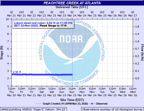
Peachtree Creek in Atlanta challenged record but looks to be coming down now.
Posted on 9/27/24 at 10:40 am to halleburton
quote:
Valdosta ia currently showing 35mph winds while being IN the eye wall, with a max forecast of 45. I absolutely love these threads and use them for planning, and take nothing from the knowledgeable Mets on here, but the actual data isn’t jiving with the forecast/projections, and it hasn’t for several years now.
I mean it’s pretty obvious from the satellite presentation this was a major hurricane.

Posted on 9/27/24 at 10:46 am to BZ504
quote:
TWC said there may be another storm in the gulf next weekend. Frick!

Posted on 9/27/24 at 10:47 am to deltaland
Valdosta has no power and plenty of trees down. Just drove through there

Posted on 9/27/24 at 10:49 am to Roll Tide Ravens
quote:
Mt. Mitchell in North Carolina (highest point east of the Mississippi River) clocked a wind gust of 108 mph.
I believe it. We went to the top of Grandfather Mountain a couple of years ago in February and I swear the wind gusts up there that day had to have been 50+ mph. It was like an arctic storm up there.
Posted on 9/27/24 at 10:50 am to NorthEndZone
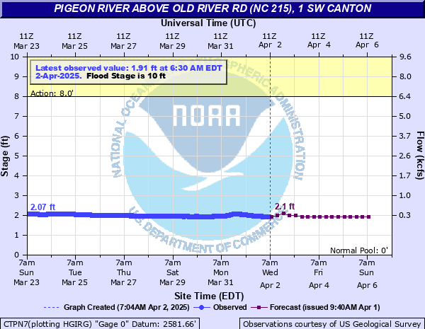
Canton, NC west of Asheville smashed record and even exceeded the forecast.
In Biltmore near Asheville another record broken
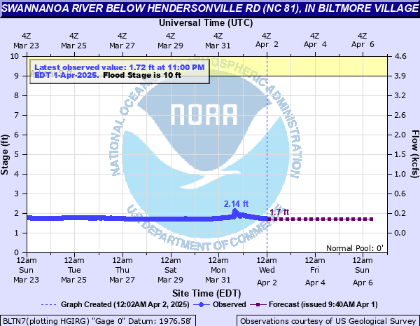
In Biltmore near Asheville another record broken
This post was edited on 9/27/24 at 10:54 am
Posted on 9/27/24 at 10:51 am to NorthEndZone
Posted on 9/27/24 at 10:52 am to BZ504
quote:
TWC said there may be another storm in the gulf next weekend. Frick!
Pretty much exactly the same track too.

Posted on 9/27/24 at 10:52 am to tigerbutt
quote:
This map is a joke. Storm is no where near the path projected over land. Why don’t haven’t they corrected this?
The remnant center of circulation is moving through northwest Tennessee and into Kentucky as it gets absorbed by the upper level low. So that cone is pretty close when it comes to where the center of circulation is and will go. The worst impacts are just displaced to the north and east of the center.
This post was edited on 9/27/24 at 11:00 am
Posted on 9/27/24 at 10:53 am to Roll Tide Ravens
and its going to park over TN/KY and just dump on it?

Posted on 9/27/24 at 10:56 am to RummelTiger
quote:
Why me?
I'm not a professional in the field.
I'm, at best these days, not even a sideline weather enthusiast...I'm likely up in the stands at this point.
Smarter people on the subject than me have already chimed in to the reasons why, but many have chosen to ignore those responses because it doesn't fit the narrative in their head. My opinion isn't going to change anyone else's, nor should it.
Historically on here you know more than most of these clowns and I also I didn't see any of the ppl that do know on here.

 Page 237 of 310

Popular
Back to top