- My Forums
- Tiger Rant
- LSU Recruiting
- SEC Rant
- Saints Talk
- Pelicans Talk
- More Sports Board
- Fantasy Sports
- Golf Board
- Soccer Board
- O-T Lounge
- Tech Board
- Home/Garden Board
- Outdoor Board
- Health/Fitness Board
- Movie/TV Board
- Book Board
- Music Board
- Political Talk
- Money Talk
- Fark Board
- Gaming Board
- Travel Board
- Food/Drink Board
- Ticket Exchange
- TD Help Board
Customize My Forums- View All Forums
- Show Left Links
- Topic Sort Options
- Trending Topics
- Recent Topics
- Active Topics
Started By
Message

TORNADO!!! Pine Belt Tornado preliminary rating of EF-4 with 1 fatality
Posted on 4/16/20 at 10:31 am
Posted on 4/16/20 at 10:31 am

------------------------------------------------------------------------------------------------------------------


Saturday Update:


Friday Update:
quote:
NWS SPC @NWSSPC
2:35am CDT #SPC Day3 Outlook Enhanced Risk: from eastern texas eastward across the gulf coast states NWS SPC Link

OP on Thursday:
quote:
NWS SPC @NWSSPC
There is an Enhanced Risk level (3/5) for Day 4 Sunday April 19th across portions of the Southeast. Damaging Wind gusts and tornadoes will be the main hazards. For more information and later updates please visit LINK
#TXwx #LAwx #MSwx #GAwx #SCwx

This post was edited on 4/20/20 at 8:14 pm
 15
15

Posted on 4/16/20 at 10:41 am to rt3
quote:
NWS New Orleans @NWSNewOrleans
Warning sign Heads up for this upcoming Sunday, April 19th. The SPC has highlighted the entire area for the risk for severe weather. Exact specifics including timing and coverage remain low confidence, but severe weather does look very possible. Stay tuned for more updates Thunder cloud and rain #lawx #mswx


quote:
NWS Jackson MS @NWSJacksonMS
Severe thunderstorms are likely Sunday afternoon into Sunday evening. The main threat will be for damaging winds up to 60-70mph and large hail up to golf ball size. A tornado also cannot be ruled out.

This post was edited on 4/19/20 at 12:01 pm

Posted on 4/16/20 at 10:42 am to rt3
Weird how the frequency of tornadoes has increased in Dixie Alley over the last decade or so. Tornadoes were synonymous with the Midwest for years now it’s more prevalent in the southern part of the country.

Posted on 4/16/20 at 10:46 am to Paul Allen
quote:
Weird how the frequency of tornadoes has increased in Dixie Alley over the last decade or so. Tornadoes were synonymous with the Midwest for years now it’s more prevalent in the southern part of the country.
It's the season. In another month these will be moving to the midwest.
Posted on 4/16/20 at 10:48 am to rt3
This is a different setup than last Sunday and will probably favor a well defined MCS blasting across the area, this should limit the possibility for strong long tracked tornadoes.
Posted on 4/16/20 at 10:50 am to rds dc
hope its late Sunday. I'm supposed to be golfing Sunday morning.
Posted on 4/16/20 at 10:50 am to Paul Allen
quote:
Weird how the frequency of tornadoes has increased in Dixie Alley over the last decade or so. Tornadoes were synonymous with the Midwest for years now it’s more prevalent in the southern part of the country.
Not really much of an increase. This time of year in the deep south has always seen tornadoes. The increased reliability of forecasting, the improvement of radar, and the advancement of storm survey teams has all made it easier to identify tornadoes. A denser population also provides more opportunity for damaging tornadoes to be reported. What used to just be "wind damage" has now become low-end EF-0 or 1 tornado damage.
You could point to 1974 for evidence, but you can go farther back for regular examples.
Posted on 4/16/20 at 11:21 am to deeprig9
quote:
Weird how the frequency of tornadoes has increased in Dixie Alley over the last decade or so. Tornadoes were synonymous with the Midwest for years now it’s more prevalent in the southern part of the country.
quote:Yep, it's nothing new, it's April.
It's the season. In another month these will be moving to the midwest.
And in my case, April in Mississippi, and that means tornadoes.
If it weren't for tornados it'd be my favorite month of the year because every March someone close to me dies, and in April there are man eating tornadoes, so May wins my award as, "best month of the year."
Like you said, the Midwest will get their fair share as soon as we move into May and June.

Posted on 4/16/20 at 11:22 am to rt3

Posted on 4/16/20 at 11:29 am to rt3
There they go again with the enhanced risk graphic so far in advance. I'd rather see them say "you know what, there's the potential for severe weather in the deep south on Sunday. Stay tuned for more accurate info as we get closer".
Posted on 4/16/20 at 11:48 am to TDsngumbo
quote:
There they go again with the enhanced risk graphic so far in advance. I'd rather see them say "you know what, there's the potential for severe weather in the deep south on Sunday. Stay tuned for more accurate info as we get closer".
here's my solution
flip "moderate" & "enhanced"
make "moderate" the 3/5 & "enhanced" the 4/5
to me... moderate sounds less severe than enhanced
Posted on 4/16/20 at 11:57 am to rt3
Not this crap again
Posted on 4/16/20 at 12:02 pm to rt3
Christ Mississippi can't catch a break

Posted on 4/16/20 at 12:07 pm to rt3

Posted on 4/17/20 at 8:30 am to rds dc
quote:
This is a different setup than last Sunday and will probably favor a well defined MCS blasting across the area, this should limit the possibility for strong long tracked tornadoes.
Keep us updated WRT this assessment, thanks.
Posted on 4/17/20 at 9:13 am to Champagne
I never believe these weathermen. Called for 100% in Metarie last weekend. Barely wet the concrete
Posted on 4/17/20 at 9:17 am to Champagne
quote:
NWS SPC @NWSSPC
2:35am CDT #SPC Day3 Outlook Enhanced Risk: from eastern texas eastward across the gulf coast states NWS SPC Link
Posted on 4/17/20 at 9:26 am to rt3
from this morning's update
ETA: to help out the Johnny Regs like me who don't understand meteorology abbreviations...
MCS = mesoscale convective system... which is basically just a line of storms
quote:
...East TX to GA and SC...
Early day storms are likely to be ongoing over northern MS and AL
related to warm advection. These storms may pose a hail threat
initially. With time, these storms may transition to surface based,
with an evolving threat of damaging winds or tornadoes from AL into
GA coincident with a 300+ m2/s2 ESRH max.
To the west, other storms are likely early to midday over eastern
TX, but storm mode is uncertain. Given the increasing lift,
especially after 18Z across LA and MS, an MCS will be possible. In
addition, supercells, possibly tornadic, may form ahead of any MCS
over LA and MS. The general model trend is for upscale growth, and
this could be a combination of storm modes. At any rate, tornadoes,
damaging wind, and large hail will all be possible.
ETA: to help out the Johnny Regs like me who don't understand meteorology abbreviations...
MCS = mesoscale convective system... which is basically just a line of storms
This post was edited on 4/17/20 at 9:36 am

Posted on 4/17/20 at 11:32 am to rt3
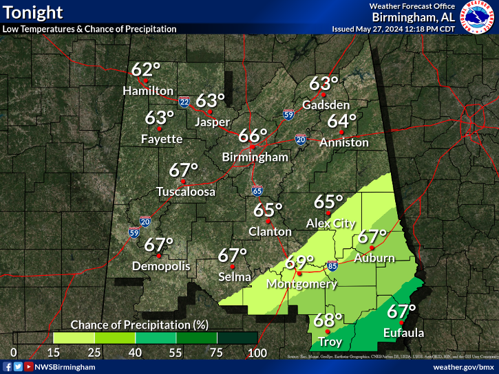
NWS Birmingham:
NWS Mobile:
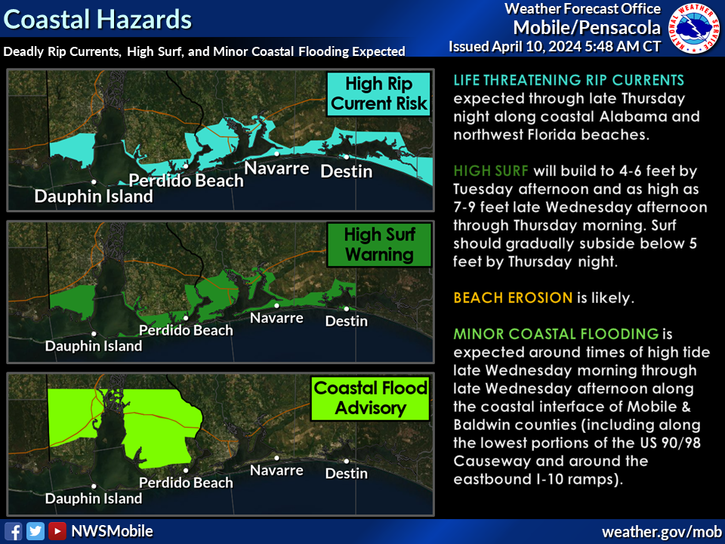
NWS Mobile:
Posted on 4/17/20 at 3:03 pm to Roll Tide Ravens
the Storm Prediction Center starting to look at tonight/into tomorrow morning for some possible heavy weather tonight from Houston towards Alexandria, Lake Charles, Lafayette


 Page 1 of 34

Popular
Back to top