- My Forums
- Tiger Rant
- LSU Recruiting
- SEC Rant
- Saints Talk
- Pelicans Talk
- More Sports Board
- Fantasy Sports
- Golf Board
- Soccer Board
- O-T Lounge
- Tech Board
- Home/Garden Board
- Outdoor Board
- Health/Fitness Board
- Movie/TV Board
- Book Board
- Music Board
- Political Talk
- Money Talk
- Fark Board
- Gaming Board
- Travel Board
- Food/Drink Board
- Ticket Exchange
- TD Help Board
Customize My Forums- View All Forums
- Show Left Links
- Topic Sort Options
- Trending Topics
- Recent Topics
- Active Topics
Started By
Message
re: Tornado! - Bassfield, MS rated EF-4 w/ 63 Mile Track, Peak Winds 170 mph
Posted on 4/11/20 at 9:26 pm to 50_Tiger
Posted on 4/11/20 at 9:26 pm to 50_Tiger
KSAT (San Antonio) Live Coverage of Tornado Warning
ETA: seems like the tornado warning is about to expire and be replaced with a severe thunderstorm warning
ETA: seems like the tornado warning is about to expire and be replaced with a severe thunderstorm warning
This post was edited on 4/11/20 at 9:29 pm
 2
2

Posted on 4/11/20 at 9:28 pm to Bobby OG Johnson
quote:
Del Rio hail
DOOD
Randy Johnson can kill some unfortunate pigeons with those hailstones

Posted on 4/11/20 at 9:31 pm to rt3
It had to go right over the radar site. Which is still up. Which is kinda good news?

Posted on 4/11/20 at 9:33 pm to rt3
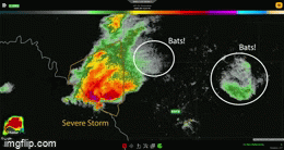
quote:
RadarOmega
@RadarOmega_WX
Check out this severe storm this evening near Del Rio, TX. It looks like storms off to the N and NE of the radar, but nope! It's bats!
You can see this with Correlation Coefficient. Non-meteorological (but biological, aka bats/birds/insects) values are values less than 0.80.
Man frick 2020

Posted on 4/11/20 at 9:33 pm to 50_Tiger
quote:
It had to go right over the radar site. Which is still up. Which is kinda good news?
NWS allowed the tornado warning to expire and replaced it with a severe thunderstorm warning... which is also kinda good news too
Posted on 4/11/20 at 9:34 pm to Bobby OG Johnson
the bats knew the tornado was coming and wanted to GTFO
Posted on 4/11/20 at 9:36 pm to rds dc
NAM shows no development of discrete cells in south louisiana tomorrow?

but shows development of the squall line later on around southeast louisiana?

but shows development of the squall line later on around southeast louisiana?

Posted on 4/11/20 at 9:36 pm to rt3
Here's your tornado coming from Del Rio...


Posted on 4/11/20 at 9:37 pm to rt3
Feeding time! Sun is down.
Posted on 4/11/20 at 9:37 pm to RummelTiger
this KSAT weather girl (link provided above) is quite cute
Posted on 4/11/20 at 9:38 pm to rt3
I would have dipped out too 

Posted on 4/11/20 at 9:40 pm to rt3
Meh
Probably had too many Sunday after church buffets
Probably had too many Sunday after church buffets
Posted on 4/11/20 at 9:41 pm to rt3
KSAT may be worth a watch on regular days
2 of their meteorologists...
Sarah Spivey (blonde) & Kaiti Blake (brunette)

Kaiti Blake is on air right now for this severe weather event... wearing a somewhat similar (but not exactly) dress to what's in the pic above
2 of their meteorologists...
Sarah Spivey (blonde) & Kaiti Blake (brunette)
Kaiti Blake is on air right now for this severe weather event... wearing a somewhat similar (but not exactly) dress to what's in the pic above
Posted on 4/11/20 at 9:43 pm to rt3
Zero chance that SCell doesnt spawn another Tornado.
Posted on 4/11/20 at 10:04 pm to rt3
Yanet will always remain my #1


Posted on 4/11/20 at 10:04 pm to DVinBR
quote:
NAM shows no development of discrete cells in south louisiana tomorrow?
I wouldn't necessarily rely on the NAM for purposes of determining storm mode or storm placement. It isn't a convection allowing model, and is not always the best at hitting convective mode and placement.
Posted on 4/11/20 at 10:20 pm to 50_Tiger
Some of the future radars are showing San Antonio getting hammered at about 2:30 - 4:00 AM CDT. Hopefully just a strong squall line and nothing rotating seriously.
I hope everyone is paying attention.
I hope everyone is paying attention.

Posted on 4/11/20 at 10:32 pm to notiger1997
quote:
You are by far the most annoying poster in these weather threads

Posted on 4/11/20 at 10:39 pm to TDsngumbo
Looks like the rotation got stronger again just NW of Uvalde. If it dips a little more south, it could threaten some of the towns along US 90 all the way into San Antonio metro area.
Posted on 4/11/20 at 10:44 pm to NorthEndZone
This little guy popped out at 10:30 - did not see a Tornado Warning issued though:
 [/img]
[/img]
 Page 9 of 70

Popular
Back to top