- My Forums
- Tiger Rant
- LSU Recruiting
- SEC Rant
- Saints Talk
- Pelicans Talk
- More Sports Board
- Fantasy Sports
- Golf Board
- Soccer Board
- O-T Lounge
- Tech Board
- Home/Garden Board
- Outdoor Board
- Health/Fitness Board
- Movie/TV Board
- Book Board
- Music Board
- Political Talk
- Money Talk
- Fark Board
- Gaming Board
- Travel Board
- Food/Drink Board
- Ticket Exchange
- TD Help Board
Customize My Forums- View All Forums
- Show Left Links
- Topic Sort Options
- Trending Topics
- Recent Topics
- Active Topics
Started By
Message
re: Tornado! - Bassfield, MS rated EF-4 w/ 63 Mile Track, Peak Winds 170 mph
Posted on 4/10/20 at 10:11 pm to BPTiger
Posted on 4/10/20 at 10:11 pm to BPTiger
quote:
I must have heard explosive cyclogenesis on the radio 30 times today. Granted it was the same report being repeated.
It's going to be an impressive midlat cyclone for sure
 1
1


Posted on 4/11/20 at 1:13 am to rds dc
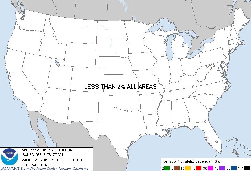 TORNADO PROBS
  WIND PROBS
 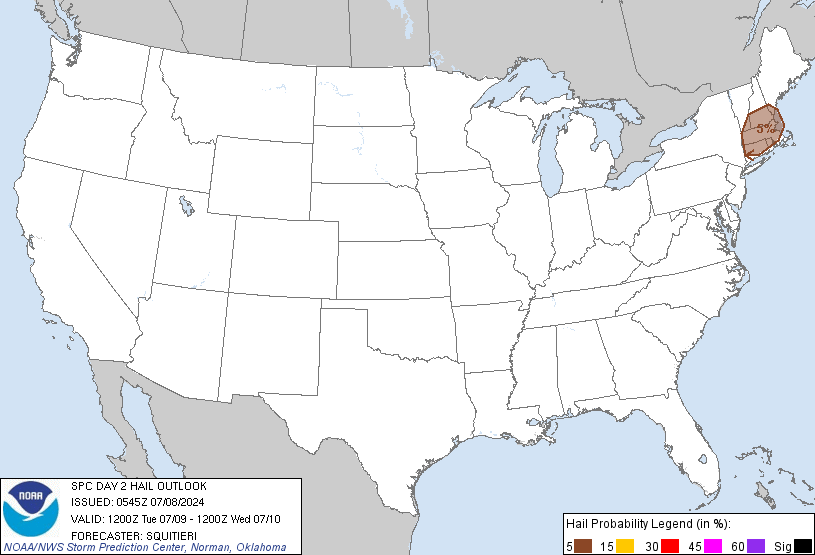 HAIL PROBS
Posted on 4/11/20 at 7:44 am to lsuman25
Looks like the southern stretch of enhanced was trimmed a bit and the moderate looks identical. When does the SPC release another update?
And by the way, still liking those hail probabilities. It’s a shame my garage is so full of crap right now due to spring cleaning. Real shame.
And by the way, still liking those hail probabilities. It’s a shame my garage is so full of crap right now due to spring cleaning. Real shame.
This post was edited on 4/11/20 at 8:08 am
Posted on 4/11/20 at 7:48 am to TDsngumbo
Any better idea as a time line for this in the BR area?
Posted on 4/11/20 at 8:17 am to TDsngumbo
Not trimmed enough I’m still well in the red where I’m at. Thing is I’m waiting to see if the pink spot shows up before long and I’m hoping I’m not in it. I’ve been saying prayers since yesterday, and prayers to all out there stay safe and listen for the warnings.
Posted on 4/11/20 at 9:07 am to 4EvEr Bo REIN
From the SPC:
quote:
East TX northeastward through much of the Southeast and TN Valley... One or more clusters of deep convection will likely be ongoing at 12Z Sunday morning somewhere over east TX and potentially into portions of the lower MS Valley. The intensity and areal extent of any such clusters remain uncertain, but ample shear and instability will favor a threat of hail and damaging wind with any organized convection at the start of the period. Some tornado threat will also be present Sunday morning with any semi-discrete storms that begin to interact with the richer low-level moisture in the vicinity of the warm front. As this convection spreads northeastward, intensification is possible into portions of the ArkLAMiss region, with an increasing tornado threat in late morning/early afternoon with any surface-based storms, given rapidly increasing low-level moisture and shear. North of the warm front, evolution into a QLCS will be possible, with a corresponding risk of damaging wind into portions of the TN Valley.
Meanwhile, further south, moderate to locally strong instability is forecast to develop along/south of the warm frontal position, which will be modulated by the impact of outflow from any early convection described above. Midlevel flow will increase to 70-100 kt as a south-southwesterly low-level jet intensifies into the 40-60 kt range. These wind profiles combined with ample instability (MLCAPE of 1500-3000 J/kg) will support the potential for intense supercells. Any surface-based initiation along and east of a pseudo-dryline moving into western LA by late afternoon could evolve into one or more long-tracked supercells capable of producing strong tornadoes, large hail, and damaging wind gusts. The extent of development within the warm sector remains somewhat uncertain, given the presence of a capping inversion and generally subtle foci for initiation. While the conditional risk of all severe hazards will be quite high if supercells develop, uncertainty remains regarding how convection will evolve from the morning into the afternoon. Any remnant outflow related to early convection will determine the northern extent of the higher-end tornado potential, and some guidance suggests the potential for elevated convection within a midlevel moist plume across the warm sector during the afternoon, which could either dampen the severe potential, or evolve into surface-based convection with a substantial severe threat. Given these factors, there is too much uncertainty to upgrade the ongoing outlook at this time.
Posted on 4/11/20 at 9:13 am to East Coast Band
In other words,
“We were wrong with our initial enhanced outlook in southern Louisiana. As is usually the case, the atmosphere will simply be too stable near the coast and shite won’t pop off until you get to southern Mississippi, Opelousas, and points further north. We apologize for hyping this event so soon in the far southern areas”.
“We were wrong with our initial enhanced outlook in southern Louisiana. As is usually the case, the atmosphere will simply be too stable near the coast and shite won’t pop off until you get to southern Mississippi, Opelousas, and points further north. We apologize for hyping this event so soon in the far southern areas”.
Posted on 4/11/20 at 9:16 am to East Coast Band
quote:
there is too much uncertainty to upgrade the ongoing outlook at this time.
We'll have to pray that this uncertainty evolves into disorganized convection that doesn't support tornadoes. Blustery day is much better than Tornadic day.
Posted on 4/11/20 at 9:38 am to TDsngumbo
Which would be a best case scenario we don’t need any tornadoes with all of this other shite going on.
Posted on 4/11/20 at 9:48 am to Champagne
When was it? Last year? when there was this major tornado outbreak forecast that ended up being much less than expected?
Then, about a month later storms brewed up were worse than what occurred on the "bad" forecast day.
Then, about a month later storms brewed up were worse than what occurred on the "bad" forecast day.

Posted on 4/11/20 at 9:56 am to East Coast Band
quote:
some guidance suggests the potential for elevated convection within a midlevel moist plume across the warm sector during the afternoon, which could either dampen the severe potential, or evolve into surface-based convection with a substantial severe threat.
This is a big question for Sunday. Do we get a bunch of junk convection over the warm sector that is elevated and sub-severe/marginally severe and "contaminates" the warm sector?
Posted on 4/11/20 at 10:09 am to Roll Tide Ravens
quote:
quote:
some guidance suggests the potential for elevated convection within a midlevel moist plume across the warm sector during the afternoon, which could either dampen the severe potential, or evolve into surface-based convection with a substantial severe threat.
This is a big question for Sunday. Do we get a bunch of junk convection over the warm sector that is elevated and sub-severe/marginally severe and "contaminates" the warm sector?
It looks like a lot of the hi-res models like the solution of multiple rounds of elevated storm clusters before the Pacific front over takes things and everything lines out. This is a very dynamic system and there might be enough forcing to keep things messy. However, even at this range things are still highly uncertain for tomorrow. Watch storms across Texas later today to see if they develop into a complex that maintains overnight bringing rain into the warm sector tomorrow morning.
Posted on 4/11/20 at 10:40 am to rds dc
quote:
It looks like a lot of the hi-res models like the solution of multiple rounds of elevated storm clusters before the Pacific front over takes things and everything lines out.
I've seen a few people suggest that they don't think hi-res models/CAMs are handling the setup well, and that junk convection will be more limited that what they are currently suggesting. I don't know what to think.
Posted on 4/11/20 at 10:43 am to East Coast Band
quote:
When was it? Last year? when there was this major tornado outbreak forecast that ended up being much less than expected?
Then, about a month later storms brewed up were worse than what occurred on the "bad" forecast day.
I don't know.
Posted on 4/11/20 at 10:45 am to Roll Tide Ravens
quote:
I've seen a few people suggest that they don't think hi-res models/CAMs are handling the setup well, and that junk convection will be more limited that what they are currently suggesting. I don't know what to think
Don't worry about the CAMs till tomorrow morning. Day 1 we can worry about the mesoscale once we have some actual data to work with.
Posted on 4/11/20 at 10:53 am to Roll Tide Ravens
quote:
I've seen a few people suggest that they don't think hi-res models/CAMs are handling the setup well, and that junk convection will be more limited that what they are currently suggesting. I don't know what to think.
It's hard to say but it is a pretty consistent signal across the CAMs but they are subject to wild swings at this range. There is some support for this solution from the global models when you look at the upper levels. A lot of big days have morning rain and a lot depends on how fast things can clear out. The Gulf is on fire and it wouldn't take long for return flow to pump things up.


Posted on 4/11/20 at 10:59 am to East Coast Band
quote:
When was it? Last year? when there was this major tornado outbreak forecast that ended up being much less than expected?
Then, about a month later storms brewed up were worse than what occurred on the "bad" forecast day.
Shreveport NWS took it on the chin a few times last spring. I met one of the guys in the office a few months ago and gave him the business about it a little bit and he was like yeah.. what ya gonna do.
Posted on 4/11/20 at 11:22 am to The Boat
so roundabouts should this shite start popping off in Texas today?
Posted on 4/11/20 at 11:33 am to rds dc
quote:
Watch storms across Texas later today to see if they develop into a complex that maintains overnight bringing rain into the warm sector tomorrow morning.
Could you please address this point again this evening? I'd like to keep an eye on Fort Polk weather radar to evaluate how this question resolves. Of course, we'd learn a lot more from your insight at that time.
Fort Polk weather radar must be very good because it is the same radar that the Fort Polk Army Airfield uses, so I think that would be a good radar to look at.

 Page 5 of 70

Popular
Back to top