- My Forums
- Tiger Rant
- LSU Recruiting
- SEC Rant
- Saints Talk
- Pelicans Talk
- More Sports Board
- Fantasy Sports
- Golf Board
- Soccer Board
- O-T Lounge
- Tech Board
- Home/Garden Board
- Outdoor Board
- Health/Fitness Board
- Movie/TV Board
- Book Board
- Music Board
- Political Talk
- Money Talk
- Fark Board
- Gaming Board
- Travel Board
- Food/Drink Board
- Ticket Exchange
- TD Help Board
Customize My Forums- View All Forums
- Show Left Links
- Topic Sort Options
- Trending Topics
- Recent Topics
- Active Topics
Started By
Message
re: The Great Flood of 2016: Fill Out Disaster Forms NOW. Link Inside!
Posted on 8/13/16 at 8:12 pm to supernovasky
Posted on 8/13/16 at 8:12 pm to supernovasky
Thanks for that ray of sunshine :(
 0
0

Posted on 8/13/16 at 8:12 pm to supernovasky
that includes bayou fountain, correct?
Posted on 8/13/16 at 8:13 pm to The Pirate King
There are a lot of boats going in and out to a couple of different drop off points. What kind of rig is he in?

Posted on 8/13/16 at 8:14 pm to PhiTiger1764
quote:
includes bayou fountain, correct?
Correct... unfortunately
Posted on 8/13/16 at 8:14 pm to supernovasky
That's what I'm very afraid of. I live in a reasonably unaffected area in st. Amant, that lies very close to black bayou. I have a feeling, we are gonna be swamped.
Posted on 8/13/16 at 8:14 pm to supernovasky
That last 15.5 reading of Amite/Manchac was at 4:30. Does anybody know what the current reading is?
Posted on 8/13/16 at 8:15 pm to supernovasky
I can speak from experience on the backflow after the March floods in Covington. Basically the river can't pump the water out fast enough so the canals hold the water which hold the water up even further upstream. I watched water going backwards from our neighborhood retention pond they the ditches. It's weird bc you think you are in the clear, go to bed, wake up to find your front yard flooded but it hasn't rained in 12hrs. So be safe and smart out there.

Posted on 8/13/16 at 8:15 pm to biohzrd
I'm not sure. I know he was driving at one point. He was shuttling people back and forth to frog's
Posted on 8/13/16 at 8:16 pm to HamCandy
Rain stopped so I took the drone out for a quick survey. This is on the corner of 44 and cornerview. East Ascension football field on the left.
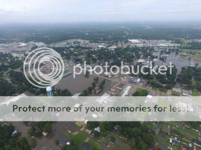

Posted on 8/13/16 at 8:16 pm to TigeRoots
Just moved to Keystone of Galvez in Prairieville. Can someone familiar with this area tell me if I should expect water getting in my house at any point through this shite?
TIA
TIA

Posted on 8/13/16 at 8:16 pm to Tiger2287
Might want to load up emergency provisions and review your evacuation plan in case it becomes necessary to evacuate. Can never be too prepared. Might also want to have a backup plan if the first plan goes to shite.
Posted on 8/13/16 at 8:17 pm to TigeRoots
Looks like the backflow is starting around Old Hammond according to the gauge.

Posted on 8/13/16 at 8:19 pm to The Pirate King
At one point they had about 1200 people at frogs. Hopefully he is ok. I haven't heard of anyone missing in the area as far as rescuers are concerned. Here's what it looked like when I was there.

This post was edited on 8/13/16 at 8:22 pm

Posted on 8/13/16 at 8:20 pm to NorthEndZone
Posted on 8/13/16 at 8:21 pm to PsychTiger
Yeah. Because the bayou is already flooded over the roads, and our drainage in our neighborhood has already flooded the roads, the land it built up a some. But that's a lot of water up north that has to go somewhere.
Posted on 8/13/16 at 8:24 pm to NorthEndZone
What's up with the radar..not that big into weather but it just looks like it's disappearing kind of...what's causing it to do that? From the forecast earlier was looking like 80 percent chance and has moved down to 60 percent chance of rain through the night...appreciate any responses!
Posted on 8/13/16 at 8:24 pm to loogaroo
This will be the first gauge that backwater flooding will be seen. It is already happening here:
LINK
This next gauge will show backwater flooding:
LINK
Also happening.
Then this one:
LINK
POSSIBLY happening. I am keeping a close eye on that one. If it starts to spike, then we know backwater flooding is occurring.
Finally here... if you see this spike, Baton Rouge is in for trouble:
LINK
LINK
This next gauge will show backwater flooding:
LINK
Also happening.
Then this one:
LINK
POSSIBLY happening. I am keeping a close eye on that one. If it starts to spike, then we know backwater flooding is occurring.
Finally here... if you see this spike, Baton Rouge is in for trouble:
LINK
Posted on 8/13/16 at 8:27 pm to supernovasky
Could this back flow potentially impact the Spring Lake area near Bluebonnet or even the LSU area?
Posted on 8/13/16 at 8:28 pm to CENLALSUFAN
quote:
What's up with the radar..not that big into weather but it just looks like it's disappearing kind of...what's causing it to do that? From the forecast earlier was looking like 80 percent chance and has moved down to 60 percent chance of rain through the night...appreciate any responses!
it seems the storm is cycling... look west to Beaumont area... it's raining there and even up in Alexandria it started sprouting up there
I believe the meteorologists said the storms could pop up around BR again overnight... perhaps a little more west
it's expected to happen again tomorrow... I know I'm in the bullseye tomorrow in CenLA
Posted on 8/13/16 at 8:28 pm to member12
Absolutely could hit the LSU area. All of the areas that flash flooded today are candidates for backwater flooding that could be more significant than the flash flooding.

 Page 96 of 472

Popular
Back to top