




- My Forums
- Tiger Rant
- LSU Recruiting
- SEC Rant
- Saints Talk
- Pelicans Talk
- More Sports Board
- Fantasy Sports
- Golf Board
- Soccer Board
- O-T Lounge
- Tech Board
- Home/Garden Board
- Outdoor Board
- Health/Fitness Board
- Movie/TV Board
- Book Board
- Music Board
- Political Talk
- Money Talk
- Fark Board
- Gaming Board
- Travel Board
- Food/Drink Board
- Ticket Exchange
- TD Help Board
Customize My Forums- View All Forums
- Show Left Links
- Topic Sort Options
- Trending Topics
- Recent Topics
- Active Topics
Started By
Message

 1
1



Posted on 7/21/26 at 9:34 am to alphaandomega
quote:
Rain has started in Perdido Key
Some pretty big waves coming ashore now. Nice for a short round of body surfing this AM.

Posted on 7/21/26 at 9:37 am to shiftworker
quote:
If I had never seen the exact path I would’ve guessed it went directly over my house.
And I would’ve been right.
Yea, when I tell people the eye passed over me in the northern suburbs of St. Amant/Port Vincent area, they look at me like I'm retarded. I distinctly remember watching the radar and telling my wife that the eye was about to clip our area on a wobble. We went outside in the garage to watch and sure enough the wind was gusting ferociously then suddenly was only gusting to maybe 30mph for about 15 minutes before it kicked back up from the opposite direction to probably 60-70 mph for the rest of the night until I fell asleep. It was the only time I've ever experienced the eye of a hurricane.

Posted on 7/21/26 at 9:44 am to TDsngumbo
2,1
Posted on 7/21/26 at 9:52 am to TDsngumbo
Same here in Whitehall. In the eye for the first time in my life.
Posted on 7/21/26 at 9:57 am to rds dc

Posted on 7/21/26 at 10:01 am to NorthEndZone
So trying to fly into MSY tomorrow night from Houston.. should I say screw it and rent a car and drive?
Posted on 7/21/26 at 10:05 am to NorthEndZone
quote:
Tropical Storm Bertha Discussion Number 9
NWS National Hurricane Center Miami FL AL022026
1000 AM CDT Tue Jul 21 2026
Bertha has become slightly better organized this morning. While the
low-level center was fully exposed overnight, new deep convection
has developed this morning and the center has become at least
partially tucked underneath the cold overcast. The Air Force
Hurricane Hunters have been investigating the storm, and they
reported peak 850-mb flight-level winds of 62 kt within the
convection to the southeast of the center, along with layer-averaged
dropsonde winds that support raising the initial intensity to 50 kt.
The central pressure has fallen slightly to 995 mb.
Bertha has deviated north of the forecast track during the past
several hours, and the initial motion is north-northwestward (345/3
kt). The near-term track forecast has been adjusted northward to
account for this development. While Bertha is currently in fairly
weak steering currents, a mid-level ridge centered near the Rockies
is expected to move southeastward during the next couple of days.
This should cause Bertha to turn more west-northwestward and then
westward while it moves near or along the northern Gulf Coast
through midweek. While the track models are overall in good
agreement on this scenario, there are differences in how much land
interaction with southeastern Louisiana will occur, and whether a
new center may redevelop off the coast. Little change was made to
the NHC track forecast beyond 24 h, and once again this forecast
assumes Bertha is able to maintain a cohesive circulation as it
passes near or over the northern Gulf Coast.
Bertha remains an asymmetric tropical storm, with most of the
rainfall and the strongest winds occurring to the south and east of
the center. Strong northeasterly vertical wind shear over Bertha is
forecast to persist today and tonight, which should make it
difficult for Bertha to strengthen much more. Convection is expected
to continue pulsing to the south of Bertha's center during this
time, and the NHC forecast overall shows gradual weakening over the
next few days. The extent of this weakening will depend on how much
land interaction occurs during the next couple of days, and it
remains possible that Bertha could degenerate into a trough even
sooner than forecast due to a disrupted structure within hostile
environmental conditions.
Some notable watch/warning changes were made with this advisory
package. The Tropical Storm Warning was extended eastward across
the Florida Panhandle and westward to the Terrebonne/Lafourche
Parish Line in Louisiana. In addition, the Storm Surge Watch has
been replaced with a Coastal Flood Warning issued by the local
forecast office. Minor to moderate coastal flooding is still
expected to occur between the Mississippi/Alabama Border and the
Mouth of the Mississippi River, with peak values up to 4 ft above
ground level.
This post was edited on 7/21/26 at 10:08 am
Posted on 7/21/26 at 10:05 am to CE Tiger
quote:
So trying to fly into MSY tomorrow night from Houston.. should I say screw it and rent a car and drive?
No reason to change your plan to fly.
Posted on 7/21/26 at 10:08 am to Tiger985
Just worried about delays or cancellations



Posted on 7/21/26 at 10:14 am to NorthEndZone
10 AM CDT advisory:
Max sustained winds up to 60 mph, pressure down to 995mb
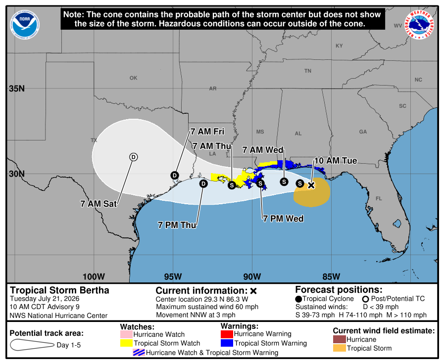
Max sustained winds up to 60 mph, pressure down to 995mb
Posted on 7/21/26 at 10:16 am to TDsngumbo
Ida was the 1st “big one” we stayed for. Zeta and Laura didn’t head our way and we’d evacuated for Katrina and others bc of kids. I won’t stay again.
Posted on 7/21/26 at 10:19 am to udtiger
quote:
Saved BR's arse though. If she stayed on her track before that jog to the east,
I was up that night listening to every report hoping it would jig to the East. Happened right before it got to BR. Yes!!!
Posted on 7/21/26 at 10:24 am to UptownJoeBrown
quote:
hoping it would jig to the East

Posted on 7/21/26 at 10:27 am to NorthEndZone
It's hard to get a perspective on the size of the waves with no reference object, but it's a little rough out there - at the Pensacola offshore NOAA buoy 42039 just east of the center.

Buoy is measuring 13 foot significant wave height. Individual waves can be twice that.

Buoy is measuring 13 foot significant wave height. Individual waves can be twice that.
Posted on 7/21/26 at 10:28 am to NorthEndZone
Oh man, 13' waves in the middle of the ocean

Posted on 7/21/26 at 10:29 am to TDsngumbo
I'm glad that Bertha is such a small threat that we have to reminisce about old Hurricanes just to feel that rush.

Posted on 7/21/26 at 10:30 am to Dixie2023
'm in Madisonville and Ida was the longest frickin' night of my life. I got out of dodge for Katrina. Wish I had done the same for Ida (then again, it was supposed to be more of a Baton Rouge problem).
Bertha is up to 60mph now. The old forecasts said she would top out at 50-55mph. So we shall see what happens.
Bertha is up to 60mph now. The old forecasts said she would top out at 50-55mph. So we shall see what happens.
This post was edited on 7/21/26 at 10:37 am


Posted on 7/21/26 at 10:35 am to boxcarbarney
quote:
I'm glad that Bertha is such a small threat that we have to reminisce about old Hurricanes just to feel that rush.
meanwhile twitter doomcasters are finding any model that can get a hurricane up the houston ship channel
Posted on 7/21/26 at 10:38 am to Dire Wolf

 Page 22 of 38

Popular
Back to top
 Follow TigerDroppings for LSU Football News