




- My Forums
- Tiger Rant
- LSU Recruiting
- SEC Rant
- Saints Talk
- Pelicans Talk
- More Sports Board
- Fantasy Sports
- Golf Board
- Soccer Board
- O-T Lounge
- Tech Board
- Home/Garden Board
- Outdoor Board
- Health/Fitness Board
- Movie/TV Board
- Book Board
- Music Board
- Political Talk
- Money Talk
- Fark Board
- Gaming Board
- Travel Board
- Food/Drink Board
- Ticket Exchange
- TD Help Board
Customize My Forums- View All Forums
- Show Left Links
- Topic Sort Options
- Trending Topics
- Recent Topics
- Active Topics
Started By
Message
re: River to crest near 20' Saturday, average levee height in N.O. is 20' (update in OP)
Posted on 7/10/19 at 4:09 pm to Patron Saint


Posted on 7/10/19 at 4:09 pm to Patron Saint
quote:
but ask the residents of the 9th ward.
Trump has shown reluctance to drop bombs.
 1
1


Posted on 7/10/19 at 4:11 pm to arseinclarse
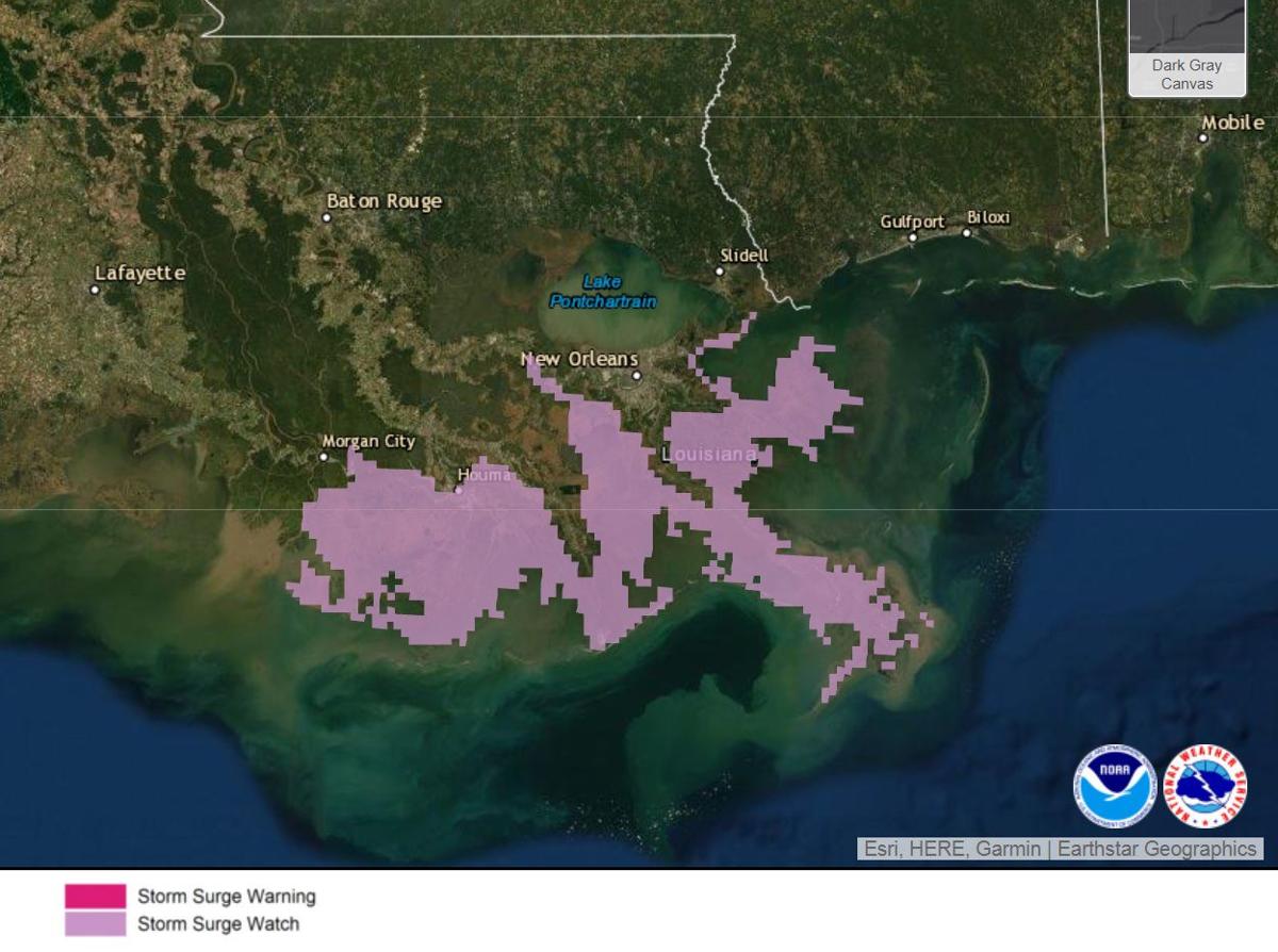
Storm surge watch issued for parts of south Louisiana in advance of the system in the Gulf of Mexico on July 10, 2019
Graphic via NHC
Jeffrey Graschel, a hydrologist with the Lower Mississippi River Forecast Center in Slidell, said the river will rise between 3 and 5 feet above its present elevation. The higher levels are expected near the mouth of the river, in Plaquemines Parish.
But the surge will make itself felt as far away as Baton Rouge, where the water level is expected to rise about 10 inches by Saturday, he said.
This post was edited on 7/10/19 at 4:13 pm
Posted on 7/10/19 at 4:11 pm to Patron Saint
quote:
Well they’re not supposed to, but ask the residents of the 9th ward.
Those weren't the Miss River levees.

Posted on 7/10/19 at 4:11 pm to notiger1997
Bunch of fricking clickbait shite. I hate weathermen during these events. 

Posted on 7/10/19 at 4:12 pm to bee Rye
Well if the river levees were being topped over by a storm surge of water wouldn’t they be susceptible to breaking?

Posted on 7/10/19 at 4:14 pm to DhanTigers212
They’re pretty damn saturated right now considering we’re at almost 6 months straight of high water. If there were spots that started being overtopped, I would think there’s at least some potential for the flow of the water overtopping to possibly compromise the levees
Posted on 7/10/19 at 4:15 pm to DhanTigers212
Yes I would thing over topping would lead to possible scouting and weakening of the sysytem. The MS River has been an angry bitch this year. We talking about a possible river height not seen since the 1920’s

Posted on 7/10/19 at 4:16 pm to TH03
I seeent George Bush and dem other Israelis do it!
Posted on 7/10/19 at 4:17 pm to bayoudude
I am not the one to overreact but I can’t help but think if we have the river overtopping our levees than they are susceptible to break which brings me to the point if I was anywhere near these levees I would be getting the frick out.

Posted on 7/10/19 at 4:20 pm to DhanTigers212
Think the core is confident with the structure of the levees, just not the height


Posted on 7/10/19 at 4:22 pm to Major Dutch Schaefer
It’s incredible to me the news isn’t making this a bigger story.
People were screaming about this when there was debate about opening the morganza and here we are.
People were screaming about this when there was debate about opening the morganza and here we are.
Posted on 7/10/19 at 4:23 pm to Swagga
quote:
People were screaming about this when there was debate about opening the morganza and here we are.
But muh farmlands................

Posted on 7/10/19 at 4:24 pm to DhanTigers212
quote:
Just wondering how high was the water when the levee broke during Katrina?
The river levees didnt break during Katrina.
Posted on 7/10/19 at 4:25 pm to NYNolaguy1
So which levees were alleged to have been blown for hurricane Besty in the lower 9th?
Posted on 7/10/19 at 4:26 pm to crewdepoo
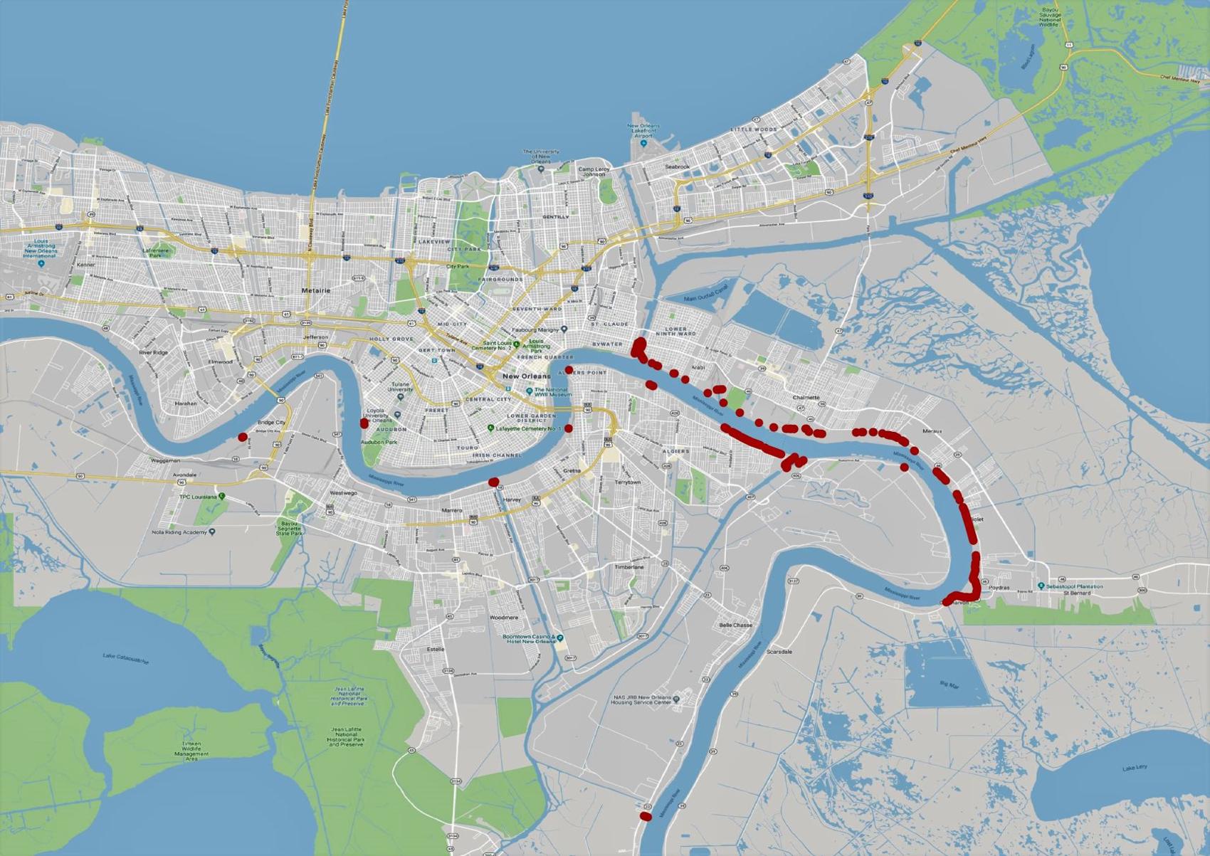
Locations in red are where levees along the Mississippi River are below 20 feet. Some locations are as low as 18 feet. The National Weather Service's Lower Mississippi River Forecast Center says the river will rise to 20 feet at the Carrollton Gauge in New Orleans on Saturday as storm surge accompanying what by then could be Category 1 Hurricane Barry moves upriver atop the 16 feet of floodwater in the river.
Army Corps of Engineers National Levee Database
A map of levee heights in the New Orleans area that's part of the Corps' National Levee Database shows that the top of large segments of river levees along the Lower 9th Ward in New Orleans and St. Bernard Parish on the east bank, and some locations in Algiers on the West Bank, were between 18 and 19.99 feet.
One low spot farther upriver happens to be the campus of the Corps' New Orleans District office, which is built along a 3,000-foot stretch of the river along Leake Avenue in the Riverbend neighborhood. According to the levee database, the campus levees protect to water heights of between 19 and 19.7 feet, making the corps' office one of the lowest points along the east bank river system in New Orleans.
Posted on 7/10/19 at 4:30 pm to CCT
quote:
So which levees were alleged to have been blown for hurricane Besty in the lower 9th?
Alleged?
I have no idea. I know USACE blew the levees in Plaquemines in 1927 for similar river flooding, and that has persisted in spawning consistent conspiracies since then.
I have a hard time believing someone blew levees during Betsy, and that's saying something as my parents were rescued off of their roof during that storm.
Posted on 7/10/19 at 4:30 pm to MrLSU
Is there at all a possibility of the river breaking the levee?


Posted on 7/10/19 at 4:31 pm to MrLSU
quote:makes sense
making the corps' office one of the lowest points along the east bank river system in New Orleans.
Posted on 7/10/19 at 4:32 pm to The Boat
The Corp should have opened the morganza along time ago now it will screw them
Posted on 7/10/19 at 4:32 pm to bee Rye
quote:
no, 20 is the lowest spot, not sure where Mr Blue Check got his "average" idea from
I wouldn't be surprised with some areas being less than 20 from longterm settlement of the soils.

 Page 2 of 7

Popular
Back to top
 Follow TigerDroppings for LSU Football News