- My Forums
- Tiger Rant
- LSU Recruiting
- SEC Rant
- Saints Talk
- Pelicans Talk
- More Sports Board
- Fantasy Sports
- Golf Board
- Soccer Board
- O-T Lounge
- Tech Board
- Home/Garden Board
- Outdoor Board
- Health/Fitness Board
- Movie/TV Board
- Book Board
- Music Board
- Political Talk
- Money Talk
- Fark Board
- Gaming Board
- Travel Board
- Food/Drink Board
- Ticket Exchange
- TD Help Board
Customize My Forums- View All Forums
- Show Left Links
- Topic Sort Options
- Trending Topics
- Recent Topics
- Active Topics
Started By
Message
re: Major Louisiana Flood Event
Posted on 3/11/16 at 12:00 pm to buffbraz
Posted on 3/11/16 at 12:00 pm to buffbraz
The area drains well where I live. But I will ride out and check on my son and daughter. They are all in the white area. My son called and said that he was glad he put a lift kit on his truck because the roads were underwater getting to his home. But it sounds as if all are high and dry.
 1
1

Posted on 3/11/16 at 12:12 pm to rickyh
Slack may have covered this in his river post. 19' is 2' higher than old record.
From NWS NO
From NWS NO
quote:
Life threatening situation developing on the Bogue Falaya River. Frcst now 62.5" at Covington & 19" at Boston Street. More info to come.
Posted on 3/11/16 at 12:16 pm to rds dc
How are we looking on anymore large amounts of rain being dumped in the area? This slow drizzle isn't too bad, I just don't need a down pour

Posted on 3/11/16 at 12:22 pm to Purple Spoon
quote:
Lived in Washington Parish for a long time. I've never seen water like that ever.
Just heard from my cousin and he said the same thing. He said so far everybody's OK but he's never seen so much flooding. That includes Katrina and Camille.

Posted on 3/11/16 at 12:25 pm to MountainTiger
The rain's stopped in Monroe, I'm just worried about the levees holding out while the Ouachita absorbs all of this.
Posted on 3/11/16 at 12:26 pm to bendellee
quote:
Not overtopped yet, but believed imminent. Impact will primarily we on west bank of bayou (Stockwell Place Subdivision). Do not believe homes in DWS to be threatened. Access to the subdivision, on the other hand . . .

LINK
Below is an article from 5:34AM this morning.
quote:
BOSSIER CITY, La. (KTBS) -
Red Chute Bayou continues rising, and Bossier Parish authorities expect water to spill over its levee this morning.
Just before 5 a.m., the water level in Red Chute where it flows through north Bossier City was 24.63 feet. The water level is falling farther south in Bossier Parish, but sheriff's deputies, National Guard members and neighbors are still trying to get about 1,000 people out of the Golden Meadows and Southgate subdivisions after new mandatory evacuation notices.
The areas around Louisiana Downs in north Bossier City also face a mandatory evacuation.
Those came a day after thousands of people in eight north Bossier City subdivisions scrambled to get out or hunker down after an evacuation order. That order affected about 3,500 homes.
The water level in Red Chute is dropping in south Bossier Parish. At 4 a.m., it was at just over 38 feet, down from a crest of almost 39 feet Thursday morning.
Deputies are letting only residents in and out of south Bossier Parish neighborhoods this morning.
LINK
Posted on 3/11/16 at 12:27 pm to rds dc
Flash Flood Emergency issued for Covington and surrounding areas
000
WGUS54 KLIX 111808
FFWLIX
LAC103-120200-
/O.NEW.KLIX.FF.W.0013.160311T1808Z-160312T0200Z/
/00000.0.ER.000000T0000Z.000000T0000Z.000000T0000Z.OO/
BULLETIN - EAS ACTIVATION REQUESTED
FLASH FLOOD WARNING
NATIONAL WEATHER SERVICE NEW ORLEANS LA
1208 PM CST FRI MAR 11 2016
...FLASH FLOOD EMERGENCY FOR WESTERN ST. TAMMANY...
THE NATIONAL WEATHER SERVICE IN NEW ORLEANS HAS ISSUED A
* FLASH FLOOD WARNING FOR...
NORTHWESTERN ST. TAMMANY PARISH IN SOUTHEASTERN LOUISIANA...
* UNTIL 800 PM CST FRIDAY
* AT 1205 PM CST...GAUGE REPORTS ABOVE RECORD STAGE ON BOGUE FALAYA
AT CAMP COVINGTON AND BOSTON STREET. RESIDUAL FLOODING REMAINS
ACROSS THE WARNED AREA.
THIS IS A FLASH FLOOD EMERGENCY FOR RESIDENTS AND POINTS ALONG
SEVERAL RIVERS INCLUDING BOGUE FALAYA AT CAMP COVINGTON AND BOSTON
STREET.
* FLOOD WATERS ARE MOVING DOWN THE BOGUE FALAYA RIVER. THE FLOOD
CREST IS EXPECTED TO REACH 62.5 CAMP COVINGTON FEET THIS AFTEROON.
FLOOD WATERS ARE MOVING DOWN THE BOGUE FALAYA RIVER. THE FLOOD
CREST IS EXPECTED TO REACH 19 FEET AT BOSTON STREET THIS AFTEROON.
* SOME LOCATIONS THAT WILL EXPERIENCE FLOODING INCLUDE...
COVINGTON...ABITA SPRINGS...MADISONVILLE AND FOLSOM.
PRECAUTIONARY/PREPAREDNESS ACTIONS...
MOVE TO HIGHER GROUND NOW. THIS IS AN EXTREMELY DANGEROUS AND LIFE
THREATENING SITUATION. DO NOT ATTEMPT TO TRAVEL UNLESS YOU ARE
FLEEING AN AREA SUBJECT TO FLOODING OR UNDER AN EVACUATION ORDER.
&&
LAT...LON 3066 8997 3030 8999 3032 9001 3032 9004
3035 9006 3037 9010 3039 9020 3037 9024
3060 9024 3061 9025 3065 9024 3071 9026
$$
Posted on 3/11/16 at 12:29 pm to MountainTiger
Did you see the video shot at Cassidy Park? 
Here's the Facebook link... I'm sure it could be found on the WGNO website too.
LINK
Here's the Facebook link... I'm sure it could be found on the WGNO website too.
LINK

Posted on 3/11/16 at 12:30 pm to terd ferguson
Oh my word.

Posted on 3/11/16 at 12:30 pm to terd ferguson
Holy shite, thats an insane amount of water.

Posted on 3/11/16 at 12:32 pm to terd ferguson
dag gum, wonder how high a levee it would take to have contained that?

Posted on 3/11/16 at 12:32 pm to terd ferguson
quote:
Did you see the video shot at Cassidy Park?
I saw that. That's nuts. Also saw a fb vid where they referred to Franklinton as an island on the news.
I heard about the flooding in northern La from a few people, but I had no idea it was this bad back in my hometown until I woke up and looked at FB this morning.
Glad my mom lives on a hill.
This post was edited on 3/11/16 at 12:36 pm

Posted on 3/11/16 at 12:33 pm to terd ferguson
Holy shite!!
Posted on 3/11/16 at 12:37 pm to jdavid1
where's all that water headed?
Posted on 3/11/16 at 12:38 pm to jdavid1
Any word on how the Amite River near Denham is going to make out?
Posted on 3/11/16 at 12:38 pm to rds dc
For those along the Amite River - make preparations soon
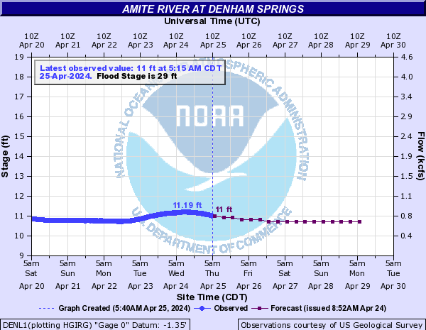
quote:
Historic Crests
(1) 41.50 ft on 04/08/1983
(2) 41.08 ft on 04/23/1977
(3) 39.88 ft on 01/27/1990
(4) 39.27 ft on 03/15/1921
(5) 38.34 ft on 06/09/2001
41.5 The river will reach the record flood of April 1983. Widespread flooding of the area between Range Avenue in Denham Springs west to Airline Highway in Baton Rouge is expected.
39 Widespread major flooding can be expected in subdivisions along Tiger Bend Road, Antioch Road, Eliot Road, and in Woodcrest and Stevendale Estates in Old Jefferson.
35 There will be moderate flooding of areas around Clay Cut Bayou, Jones Creek, and Honey Cut Bayou. In Denham Springs the area west of Florida Avenue will be subject to flooding.
30 Flooding will begin in the westernmost parts of Denham Springs. River Road at the foot of Benton Lane will flood.
quote:
Historic Crests
(1) 18.85 ft on 04/08/1983
(2) 17.50 ft on 06/10/2001
(3) 17.38 ft on 04/23/1977
(4) 16.70 ft on 01/23/1993
(5) 15.94 ft on 04/25/1979
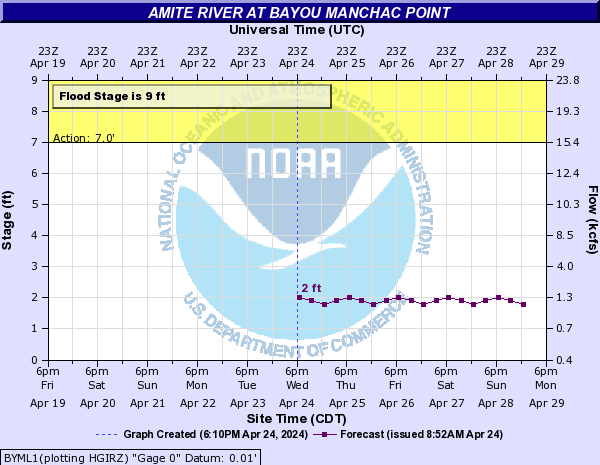
16 Homes along Highland Road and Burbank Drive will be flooded. Both streets will be impassable. Major roads will be impassable. Access to property along the river is cut off. Homes along Kendalwood Road that are not elevated will be flooded. Extensive backwater flooding will occur along Bayou Fountain and Bayou Manchac.
15 Major roads will be impassable. Access to property along the river is cut off. Homes along Kendalwood Road that are not elevated will be flooded. Extensive backwater flooding will occur along Bayou Fountain and Bayou Manchac.
14 Backwater flooding along Bayou Manchac and Bayou Fountain will flood Highland Road and Burbank Drive in places. Many homes will be threatened along the bayous from their Amite River outlets upstream to the LSU campus. Kendalwood Road and adjacent property will be inundated. Amite River Road and Horseshoe Drive will remain impassable.
12 Kendalwood Road and adjacent property will be inundated. Backwater may flood Bayou Fountain and flood some homes on Burbank Drive. Most secondary roads will be moderately flooded. Amite River Road and Horseshoe Drive will be impassable. A few homes on Horseshoe Drive will flood.
10 Amite River Road and Horseshoe Drive will be impassable. A few homes on Horseshoe Drive will flood. Water will be approaching Kendalwood Road and access to property will be threatened.
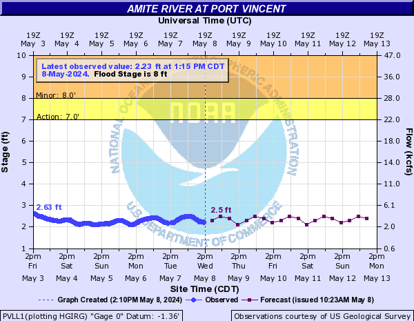
quote:
Historic Crests
(1) 14.65 ft on 04/09/1983
(2) 12.73 ft on 06/11/2001
(3) 11.96 ft on 05/21/1953
(4) 11.83 ft on 01/28/1990
(5) 11.80 ft on 01/23/1993
If you notice any errors in the below information, please contact our Webmaster
10 Increased flow and strong current will affect river traffic. Grays Creek and the main channel of the Amite River will merge. Saint Amant Swamp will be inundated. Streets will flood in Port Vincent. There will be minor flooding of residential areas.
9 Streets will flood in Port Vincent. There will be minor flooding of residential areas.
Posted on 3/11/16 at 12:42 pm to jdavid1
Historic Crests
(1) 32.00 ft on 02/03/1988
(2) 31.25 ft on 02/28/1987
28.5 Louisiana Highway 21 closed, water will be over the roadway surface of the bridge. Flowers Estates will be inundated. A few homes not elevated will flood. Homes along Old Landing and Riverbend Lane will flood. Homes near Highway 1077 and in the Tantella Ranch Road area will flood.
They don't even have a description for anything above 28.5 feet. This will be bad there.
This post was edited on 3/11/16 at 12:45 pm
Posted on 3/11/16 at 12:42 pm to DavidTheGnome
quote:
The rain's stopped in Monroe, I'm just worried about the levees holding out while the Ouachita absorbs all of this.
Yep - now worried about our SLA friends - they getting slammed.
We still have major issues in the Monroe area. We do t need any more rain. Frenchmans Bend has become a flood plain...Treasure Island is rising....state and homeland security trying to secure levee at Forsythe extension.
Tense times......good luck to all
Posted on 3/11/16 at 12:44 pm to slackster
Thanks.
My parents flooded in 83. After 32 years of paying for flood insurance my goofy arse mom cancelled the policy a while back.
She better start praying
My parents flooded in 83. After 32 years of paying for flood insurance my goofy arse mom cancelled the policy a while back.
She better start praying
Posted on 3/11/16 at 12:45 pm to KillTheGophers
15-hour forecast from the HRRR - once again looks like we may get some heavy rain in the early morning hours Saturday:


 Page 61 of 102

Popular
Back to top