- My Forums
- Tiger Rant
- LSU Recruiting
- SEC Rant
- Saints Talk
- Pelicans Talk
- More Sports Board
- Fantasy Sports
- Golf Board
- Soccer Board
- O-T Lounge
- Tech Board
- Home/Garden Board
- Outdoor Board
- Health/Fitness Board
- Movie/TV Board
- Book Board
- Music Board
- Political Talk
- Money Talk
- Fark Board
- Gaming Board
- Travel Board
- Food/Drink Board
- Ticket Exchange
- TD Help Board
Customize My Forums- View All Forums
- Show Left Links
- Topic Sort Options
- Trending Topics
- Recent Topics
- Active Topics
Started By
Message
re: Louisiana Ice Storm Thread *Winter Storm Warning*
Posted on 2/13/21 at 9:56 am to rt3

Posted on 2/13/21 at 9:56 am to rt3
New Info from NWS Weather Balloon sent up.

quote:
Rick Mitchell
@RickMitchellWX
What do I see from this morning's balloon data from FTW? A very cold column of air all the way through the atmosphere. Just a small layer of above 32. Also, lower atmosphere is moist. Both are good for snow production in N TX. #NBCDFWWeather #weathergeek
 1
1

Posted on 2/13/21 at 9:58 am to Lsuhoohoo
quote:
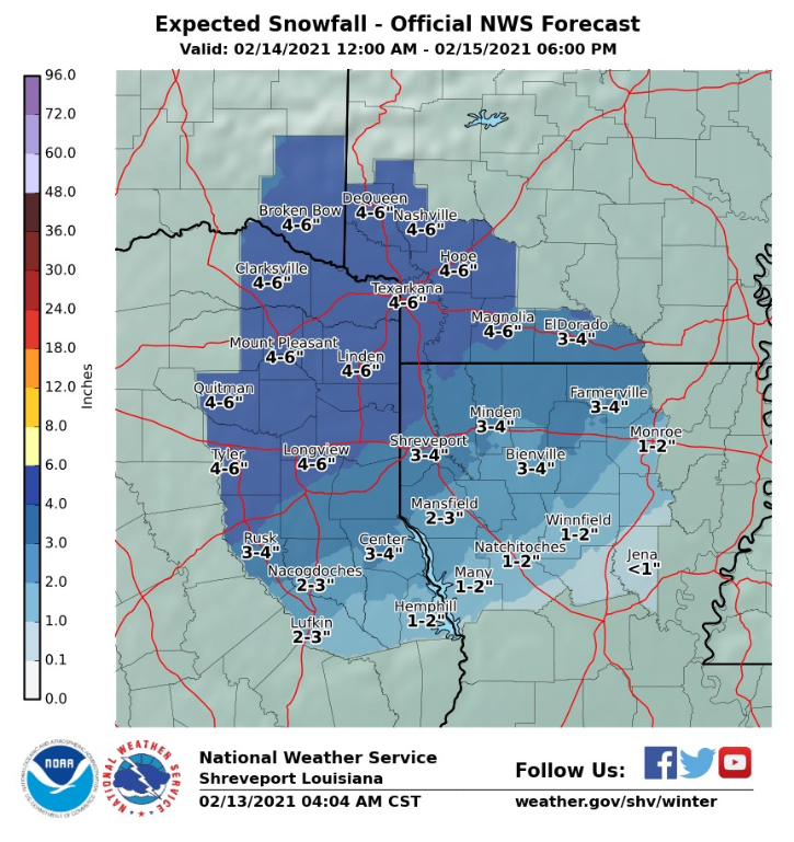
Snowfall amounts areawide will range from 1 to 2 inches across north-central Louisiana
I guess it coincides with their graphic for North central LA. but not for 80% of the population base of their area.
Their own graphic.
Posted on 2/13/21 at 10:05 am to SportTiger1
Well instead of the temperature climbing today is officially below freezing in north Iberville Parish....

Posted on 2/13/21 at 10:11 am to 50_Tiger
quote:
. Also, lower atmosphere is moist.
Posted on 2/13/21 at 10:11 am to X123F45
I’m showing 38/feels like 30 in mid iberville.
Posted on 2/13/21 at 10:13 am to dyslexiateechur
It's 31 here in Opelousas with a "feels like" of 24.
And I believe...it's cold as frick outside!
And I believe...it's cold as frick outside!
Posted on 2/13/21 at 10:16 am to Cowboyfan89
It’s 35 here in LP. But the WAFB app predicted 42 by now and still shows it’ll be up to 43° at 11 on the hourly. Is there a worse weather app out there? And why are their predictions on this so bad just 12 hours out?!?
This post was edited on 2/13/21 at 10:16 am

Posted on 2/13/21 at 10:29 am to ell_13

quote:
FIRST ALERT: WINTER STORM WATCH
A Winter Storm Watch is now in effect along and west of a line extending from New Iberia through Baton Rouge to McComb, MS from 12 a.m. Monday - 6 a.m. Monday. Ice accumulations of 0.25" or more are possible in the watch area. This weekend is the time to finalize any cold weather preparations. Uncertainty still exists on how far southeast icy conditions will reach, but I think our local NWS office has done a nice job of outlining the greatest threat area given the information we have currently.
This post was edited on 2/13/21 at 10:31 am

Posted on 2/13/21 at 10:36 am to LaBR4
I know it's late in this thread, but I started the thread on the travel board for anyone flying over the next couple days. Almost every airline has a waiver up (they added louisiana cities this morning) so happy to help people figure out when's the best time to get in/out before this storm.
Posted on 2/13/21 at 10:36 am to GeauxBlonde
quote:
Something something water and columns and noses that are warm something something...
You nailed it!
Posted on 2/13/21 at 10:39 am to TDsngumbo
LIX had FINALLY acknowledged the euro being too warm in their discussion this morning
but im not buying BR getting out of the 30s today, and if it does it will probably stop at 40
but im not buying BR getting out of the 30s today, and if it does it will probably stop at 40

Posted on 2/13/21 at 10:45 am to DVinBR
Destrehan was projected 50 by now and were still hovering 39/40. Won’t surprise me at all if this “ice storm” makes it down to St. Charles Parish.
Posted on 2/13/21 at 10:49 am to dyslexiateechur
quote:
I’m showing 38/feels like 30 in mid iberville.
32 as of this very moment in the middle of a pasture.

Posted on 2/13/21 at 10:51 am to DVinBR
NWS Houston...
Washington's Birthday
Snow and sleet before noon. Temperature falling to around 18 by 10am. Blustery, with a northwest wind 15 to 20 mph, with gusts as high as 25 mph. Chance of precipitation is 80%.
NWS Houston is one of the most conservative NWS offices in the Country. Unreal to see this in their forecast.
Posted on 2/13/21 at 10:51 am to DVinBR
quote:
but im not buying BR getting out of the 30s today, and if it does it will probably stop at 40
Meteorologists all over the south missed forecast lows for last night. Ours in North AL was forecast at 36. We were under that by 6:30 PM, and bottomed out at 29. They revised today's high to 37. It is 30 now, and I don't think it makes 37.
Posted on 2/13/21 at 10:52 am to X123F45
Sitting at 39 here in Pearl River County we were supposed to break 50 today.
Posted on 2/13/21 at 10:53 am to X123F45
Just called the guard shack and they’re showing 35. So my temp is off.

Posted on 2/13/21 at 10:53 am to DVinBR
Euro was warm for temps here in Houston the last 3 days. Had us near 50 for yesterday (from Thursday's run), but it never got out of the 30s.
Posted on 2/13/21 at 10:57 am to dyslexiateechur
Keep in mind the river is gonna tweak your temps.
I'm 9.5 miles due west of your position.
...assuming poly B
I'm 9.5 miles due west of your position.
...assuming poly B
This post was edited on 2/13/21 at 11:00 am
Posted on 2/13/21 at 10:59 am to LSUJuice
getting close to noon and my back yard is only reading 36-37 in SBR

 Page 123 of 284

Popular
Back to top