- My Forums
- Tiger Rant
- LSU Recruiting
- SEC Rant
- Saints Talk
- Pelicans Talk
- More Sports Board
- Fantasy Sports
- Golf Board
- Soccer Board
- O-T Lounge
- Tech Board
- Home/Garden Board
- Outdoor Board
- Health/Fitness Board
- Movie/TV Board
- Book Board
- Music Board
- Political Talk
- Money Talk
- Fark Board
- Gaming Board
- Travel Board
- Food/Drink Board
- Ticket Exchange
- TD Help Board
Customize My Forums- View All Forums
- Show Left Links
- Topic Sort Options
- Trending Topics
- Recent Topics
- Active Topics
Started By
Message
re: Louisiana Ice Storm Thread *Winter Storm Warning*
Posted on 2/13/21 at 9:04 am to VermilionTiger
Posted on 2/13/21 at 9:04 am to VermilionTiger
quote:
Zero chance this storm has any effect west of Lafayette
You can bank on that
 1
1

Posted on 2/13/21 at 9:05 am to Duke
quote:
The GFS also has 17" for Shreveport and 20"+ in parts of northern
I just can't wrap my head around something like this. Is this for the week or one day?
Posted on 2/13/21 at 9:06 am to tgrbaitn08
That moron is in Dukke V territory with the LeHigh upset over Duke
He’s an amateur at weather at best, and here he is speaking in absolutes based off of what other people are saying
That shite is so cringe
He’s an amateur at weather at best, and here he is speaking in absolutes based off of what other people are saying
That shite is so cringe
Posted on 2/13/21 at 9:08 am to VermilionTiger
26 degrees here this morning way colder than it was supposed to be today

Posted on 2/13/21 at 9:09 am to Duke
quote:
The Euro didn't change much from this afternoon, but for probably less ice for BR. What did stick out was the snowfall for north Louisiana. The Boat gets a foot in Monroe by the end of the week. Shreveport? 17".
I’ve got that Official TD Weather Board Gut Feeling™ about this one. Models show us getting hammered by sleet with the snow line right to the west of Monroe. But I’ve got that feeling we’re going to get slapped by snow.
This post was edited on 2/13/21 at 9:10 am
Posted on 2/13/21 at 9:12 am to 50_Tiger
quote:
ALso for DFW folks, there are many MANY reports of ice on the road already. No need to drive if you dont have to.
I was out locally around 8 am. It wasn't bad around Wylie area. I'd definitely stay off interstates though and get stuff done earlier today if you plan on doing anything that requires a drive.
Posted on 2/13/21 at 9:14 am to TigerLicks
NWS Little Rock with only the most important updates yesterday
quote:
NWS Little Rock @NWSLittleRock
We informed #Tarmactheweathercat of the entire state of Arkansas being under a Winter Storm Watch. We would say that he couldn't care less. However, that may be an understatement. :rolling eyes emoji: #arwx

Posted on 2/13/21 at 9:15 am to Uncle JackD
Delete
This post was edited on 2/13/21 at 9:16 am
Posted on 2/13/21 at 9:17 am to rt3
That nasty arse chair
Posted on 2/13/21 at 9:27 am to SportTiger1
quote:
That nasty arse chair
that chair clearly belongs to that cat
#YourTaxDollarsAtWork
Posted on 2/13/21 at 9:27 am to lachellie
From Shreveport NWS pinpoint location forecast this morning. Haven’t seen a graphic like the FW has yet.


Posted on 2/13/21 at 9:32 am to SportTiger1
quote:
I just can't wrap my head around something like this. Is this for the week or one day?
It's 26 now in the Longview area. Forecast has a low of 2 by Tuesday lol. Ridiculous. Shreveport is likely to follow that same trend.

Posted on 2/13/21 at 9:37 am to LaBR4
quote:
Jay says how do you like me now.
Breaking out the suit vest
Looks worse than Spanns suspenders.
Posted on 2/13/21 at 9:45 am to alphaandomega
From NWS Shreveport forecast discussion this morning
Now I'm no weather forecaster and I know NWS tends to be stubbornly conservative right up to the point they're not. But this seems to counter every other model and forecast.
quote:
Areas most susceptible to freezing rain impacts will be mainly Louisiana and portions of deep east Texas. Ice amounts across these areas could be as thick as a quarter of an inch. Snowfall amounts areawide will range from 1 to 2 inches across north-central Louisiana to up to 6 inches across southeast Oklahoma. Hazardous travel conditions can be expected on Monday and continuing through Tuesday.
Now I'm no weather forecaster and I know NWS tends to be stubbornly conservative right up to the point they're not. But this seems to counter every other model and forecast.
Posted on 2/13/21 at 9:46 am to alphaandomega
quote:
Meteorologist Nick Mikulas
I slept in. I mean, I woke up for an hour around 6:00 to look at everything, but then took another long winter’s nap. I’m going to do a parish by parish breakdown, so the full, wordy update will be around 10:30-11:00. But as of the 6:00 AM model check, it still looks like this is happening. If anything, models are trending even more impressive.
Posted on 2/13/21 at 9:49 am to TDsngumbo
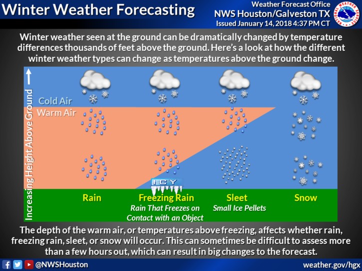
I don’t understand how weather works..... if it’s gonna rain Monday in Baton Rouge and it’s freezing temperatures outside.... why wouldn’t it snow?

Posted on 2/13/21 at 9:50 am to Frenchdip
quote:
if it’s gonna rain Monday in Baton Rouge and it’s freezing temperatures outside.... why wouldn’t it snow?
BIIIIIINNNNNGOOOOOOOO!
Now, it's because there are layers of air with this one. Cold thick air aloft, where snow can form, warm air in the middle, which the snow falls through and melts, then thin cold air at the bottom, where it can refreeze into sleet or chill into freezing rain, but the conditions are not right for it to reform into snow.
This post was edited on 2/13/21 at 9:52 am
Posted on 2/13/21 at 9:52 am to Frenchdip
quote:
I don’t understand how weather works..... if it’s gonna rain Monday in Baton Rouge and it’s freezing temperatures outside.... why wouldn’t it snow?
Short answer, precip falls through different layers of the atmosphere that vary in temperature and the type of precip will change based on what it encounters as it falls.
This post was edited on 2/13/21 at 9:54 am
Posted on 2/13/21 at 9:52 am to rt3
from Lake Charles this morning
quote:
DISCUSSION...
Rather cold and cloudy currently across the forecast area as polar
high pressure system builds down from the Canadian border toward
the Gulf of Mexico. Good news is that no precipitation is
occurring as air temperatures are near freezing in many spots.
This cold polar air mass will hang around the forecast area for
the next several days. Meanwhile, the southern jet stream will
bring warm moist air over this cold layer and remain active with
a number of upper level disturbances.
The next of these disturbances will bring a small chance for rain,
that may be freezing rain for northern portions of the forecast
area tonight. At this time, amounts do not look too significant,
however this will have to be watched closely as a winter weather
advisory may need to be issued by the next shift for tonight as
some slick spots on elevated roadways may develop.
Trends from guidance continue to show a potentially significant
winter weather event for late Sunday night into Monday as a rather
potent upper level trough and jet dynamics should bring plenty of
lift to work with abundant moisture to get widespread
precipitation going.
Forecast soundings still show a very warm layer above the cold
surface, and therefore, freezing rain will be the predominate
weather to start at with, with a gradual cooling of the layer that
sleet and possibly a little snow will mix in before it ends.
Around this part of the country winter weather events are quite a
headache to figure at and always have a degree of uncertainty
right up until it begins. Also. do not usually like to issue any
winter weather watches this early before an event. However, with
the trend toward a rather significant event and being the
weekend, decided best to go ahead and issue a winter storm watch
for a majority of the forecast area starting late Sunday night and
continuing into Monday.
The most concerning is the potential for ice accumulation with
amounts from 0.10 to 0.30 inches a good estimate currently. Winter
storm criteria with accumulations over 0.25 inches will cause
significant travel problems along with power outages. At this
point, the highest probability of that happening is roughly
northeast of a Leesville to Oakdale to Opelousas line.
After the precipitation ends Monday night and Tuesday morning look
to have bitterly cold conditions. Low temperatures were derived
from consensus means, which shows almost the entire forecast area
experiencing hard freeze conditions with lows in the teens.
Meanwhile, winds will not be calm, so speeds around 5 to 10 mph
will produce wind chill values in the single digits and with that
a wind chill advisory will be needed if this verifies.
The next disturbance will come across on Wednesday, give or take a
period. Details are still uncertain with this system, but it looks
like some type of winter precipitation may occur as it begins and
near the end of it.
Posted on 2/13/21 at 9:54 am to Frenchdip
quote:
I don’t understand how weather works..... if it’s gonna rain Monday in Baton Rouge and it’s freezing temperatures outside.... why wouldn’t it snow?
Something something water and columns and noses that are warm something something...

 Page 122 of 284

Popular
Back to top