- My Forums
- Tiger Rant
- LSU Recruiting
- SEC Rant
- Saints Talk
- Pelicans Talk
- More Sports Board
- Fantasy Sports
- Golf Board
- Soccer Board
- O-T Lounge
- Tech Board
- Home/Garden Board
- Outdoor Board
- Health/Fitness Board
- Movie/TV Board
- Book Board
- Music Board
- Political Talk
- Money Talk
- Fark Board
- Gaming Board
- Travel Board
- Food/Drink Board
- Ticket Exchange
- TD Help Board
Customize My Forums- View All Forums
- Show Left Links
- Topic Sort Options
- Trending Topics
- Recent Topics
- Active Topics
Started By
Message
 1
1

Posted on 8/21/20 at 11:49 pm to Duke
guessing we are for now head further west away from Nola
Posted on 8/21/20 at 11:50 pm to Dlab2013
yeah, you're going to predict this like you actually know what's going to happen. okay. I don't care how much education you have nobody is predicting what happens with these 2 systems other than throwing shite on the wall and hoping it sticks.
Posted on 8/21/20 at 11:55 pm to Duke
So, you’re saying Texas could get a ton of rain over a 3-4 day span.

Posted on 8/21/20 at 11:59 pm to deuce985
quote:
yeah, you're going to predict this like you actually know what's going to happen. okay. I don't care how much education you have nobody is predicting what happens with these 2 systems other than throwing shite on the wall and hoping it sticks.
JMO...I won’t take any models serious until Sunday night or Monday morning. That’s when it gets real.
Your more than welcome to bookmark the original post to....
Posted on 8/22/20 at 12:03 am to Mr. Hangover
quote:
What does your forecast map with the noodles on it look like?
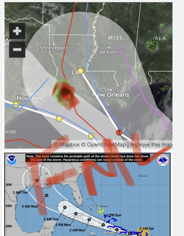
The range of outcomes is still fricking wide. Like Corpus to Mobile wide. A center reform NE where the convection is relative to the current center and you get a more eastern solution. Plus Marco could still frick with the process.
All those caveats noted, I'd say Morgan City to Houston looks the most likely target assuming a GFS like case without a center reform NE or much Marco interaction.
Subject to change, of course. It's easy to be wrong in normal situations but less this mess.
Posted on 8/22/20 at 12:08 am to Dlab2013
quote:
JMO...I won’t take any models serious until Sunday night or Monday morning. That’s when it gets real.
Your more than welcome to bookmark the original post to....
Just to be clear, you won't take any models seriously for another couple days, but you also have decided these will be nothing storms based on...
This post was edited on 8/22/20 at 12:09 am
Posted on 8/22/20 at 12:22 am to Duke
quote:
The range of outcomes is still fricking wide. Like Corpus to Mobile wide. A center reform NE where the convection is relative to the current center and you get a more eastern solution. Plus Marco could still frick with the process.
This is why I'm not banking on any track being accurate right now. Until Laura clears Cuba and redevelops a center, a broad guess at a landfall is all we are going to get. Given that the system still isn't stacked, and is still a mess right now, I'm not putting much stock in tracks at the moment.
Posted on 8/22/20 at 12:23 am to Duke
Which is the bolder prediction?
Neither make a Louisiana landfall?
Or both do?
Neither make a Louisiana landfall?
Or both do?
Posted on 8/22/20 at 12:31 am to WestSideTiger
Neither at this point, imo. But I’m far from an expert.
Posted on 8/22/20 at 1:12 am to Duke
I trust this thread more than any weather site, and have for years. I’m curious if there was a pre Katrina discussion? I remember waking up that Saturday morning like ?? and feel curiously similar... 2020 I guess

Posted on 8/22/20 at 1:44 am to JoeKennedysDrool
quote:
I trust this thread more than any weather site, and have for years
Stormcastforums deserves a shoutout too

Posted on 8/22/20 at 1:46 am to JoeKennedysDrool
Link to TD home page 15 years ago after Katrina hit
We’ve had this brought up on the board over the years about threads during Katrina, but there seems to not be a way to access them. Also, TD had A LOT less traffic back then. I dont even think you can view any threads from before a certain time (after Katrina), but someone please correct me if Im wrong.
Archived view of O-T lounge main page from November 2005
Forewarning, access inside of the threads are blocked if you try to click on them, but you can click on tiger rant, poli, etc and read the thread titles. Kind of interesting.
This post was edited on 8/22/20 at 1:49 am
Posted on 8/22/20 at 2:38 am to Ryan3232
Damn shame you can't read through those old political board threads. Bet those were fun
"WHO ARE THESE F'ING GOP HOUSE MEMBERS"
Some things never change
"WHO ARE THESE F'ING GOP HOUSE MEMBERS"
Some things never change
This post was edited on 8/22/20 at 2:39 am
Posted on 8/22/20 at 2:56 am to Pelican fan99
quote:
Damn shame you can't read through those old political board threads.
Some of them read like a really good jeopardy round.
Confucius says
African Americans
Wooohooooo
MTV Holocaust special
Anyways my 2 uneducated cents. Storm does a Rita path and hits as a 3.

Posted on 8/22/20 at 4:07 am to rds dc


Nudged ever so slightly to the west again. NHC has official forecast of a land falling hurricane with 85mph winds moving at a good pace. If that verifies then BR, being on the east side on this track, would receive 60-70 mph winds with tons of rain.
This post was edited on 8/22/20 at 4:14 am
Posted on 8/22/20 at 4:12 am to TDsngumbo
That thing is gonna end up Houston bound
Posted on 8/22/20 at 4:14 am to The Egg
We’ll see soon.

Posted on 8/22/20 at 4:17 am to TDsngumbo

 Page 75 of 815

Popular
Back to top