




- My Forums
- Tiger Rant
- LSU Recruiting
- SEC Rant
- Saints Talk
- Pelicans Talk
- More Sports Board
- Fantasy Sports
- Golf Board
- Soccer Board
- O-T Lounge
- Tech Board
- Home/Garden Board
- Outdoor Board
- Health/Fitness Board
- Movie/TV Board
- Book Board
- Music Board
- Political Talk
- Money Talk
- Fark Board
- Gaming Board
- Travel Board
- Food/Drink Board
- Ticket Exchange
- TD Help Board
Customize My Forums- View All Forums
- Show Left Links
- Topic Sort Options
- Trending Topics
- Recent Topics
- Active Topics
Started By
Message
re: Laura - President Trump visits Lake Charles, Louisiana for Hurricane Response Update
Posted on 8/25/20 at 12:17 pm to LSUFanHouston

Posted on 8/25/20 at 12:17 pm to LSUFanHouston
quote:
Dora The Explorer for y'all county judge
Destroya for NOLA mayor
To be fair, Destroya is waaaaaay worse for NOLA than the other way around. Dora doesn't run the County, the commissioners do......while blue, they have a vested interest and at least Jack Cagle is on guard (love that man).
 0
0


Posted on 8/25/20 at 12:18 pm to Loungefly85
Why do state offices in St. Tammany, Orleans, Plaquemines and St. Bernard need to be closed?
Posted on 8/25/20 at 12:18 pm to Mr. Hangover
quote:
anyone evacuating east that can provide an update of the traffic
99% chance of a cluster f@ck with the bridge in BR on a normal day, I’d expect it to be extra spicy later this afternoon/evening. Might save you some headache if you get off and take 190 and the old bridge.
This post was edited on 8/25/20 at 12:19 pm

Posted on 8/25/20 at 12:18 pm to DVinBR
quote:
seeing another big convective burst around the center
She is gonna explode sooner than later, there is no doubt about it...
Posted on 8/25/20 at 12:20 pm to DVinBR

im going to need someone to explain how marco is going to come back as a cat 1/2 at the same exact time Laura is pushing through.
not even sure how a model could come to that conclusion.


Posted on 8/25/20 at 12:20 pm to td1
after you deal with the mess on the basin bridge

Posted on 8/25/20 at 12:20 pm to slackster
Put a "stop derailing this thread with silly bullshite" square on there
Posted on 8/25/20 at 12:21 pm to Jake88
The bullseye looks like somewhere closer to Beaumont or the state line right now with potentially a further shift to Houston. I wonder how much more west it will go but the models seem to love just west of the state line.

Posted on 8/25/20 at 12:22 pm to Mr. Hangover
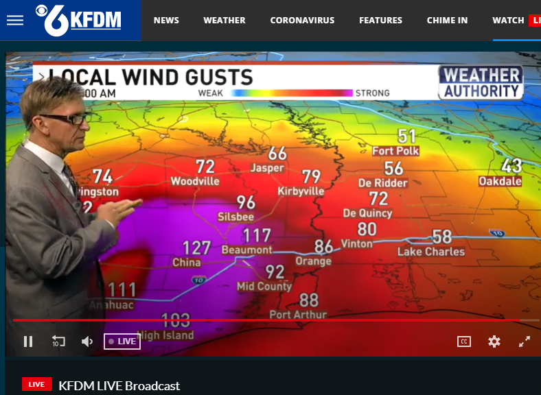
Beaumont local News Wind Map
Posted on 8/25/20 at 12:22 pm to SportTiger1
Does Laura overrun where Marco is supposed to be an the winds from Laura get placed on that chart?

Posted on 8/25/20 at 12:22 pm to Jake88
quote:
Why do state offices in St. Tammany, Orleans, Plaquemines and St. Bernard need to be closed?
To be fair, these places are still going to see wind and rain tomorrow and I'm guessing people will also be heading this way to gtfo of the way. Being this early it's not a terrible move.
Posted on 8/25/20 at 12:22 pm to SportTiger1
Is Marco even on the map any more. We got about 10 mins of rain from him this morning....
Posted on 8/25/20 at 12:23 pm to Tiger Ryno
I'm heading up to Jasper after my 1pm call to help them board up the windows and sandbag the Lion's Club. We must protect our most precious landmarks.
Posted on 8/25/20 at 12:23 pm to rds dc
im worried about those strong rain bands in baton rouge, can bring hurricane force gusts and tornados
Posted on 8/25/20 at 12:23 pm to SportTiger1


Posted on 8/25/20 at 12:24 pm to LaBR4
Would love to k ow how they generated this wind gust graphic. Lake Charles with only 58??? shite I should play golf at Atchafalaya tomorrow based on that shite.
Posted on 8/25/20 at 12:24 pm to Howyouluhdat
quote:
Look for the precipitation shaft to increase along the outer bands of the eye wall

Posted on 8/25/20 at 12:25 pm to CaptainJ47
quote:
Would love to k ow how they generated this wind gust graphic. Lake Charles with only 58???
This was only at a certain time well after landfall
This post was edited on 8/25/20 at 12:27 pm
Posted on 8/25/20 at 12:27 pm to MightyYat
There's risk of tornadoes in that path too as it's probably harder to pinpoint where exactly the worst tornado path is going to be in the hurricane.


Posted on 8/25/20 at 12:28 pm to CaptainJ47
quote:
Would love to k ow how they generated this wind gust graphic. Lake Charles with only 58??? shite I should play golf at Atchafalaya tomorrow based on that shite.
Look at where they have it going. Dude is wishcasting it into Houston hard.

 Page 325 of 815

Popular
Back to top
 Follow TigerDroppings for LSU Football News