- My Forums
- Tiger Rant
- LSU Recruiting
- SEC Rant
- Saints Talk
- Pelicans Talk
- More Sports Board
- Fantasy Sports
- Golf Board
- Soccer Board
- O-T Lounge
- Tech Board
- Home/Garden Board
- Outdoor Board
- Health/Fitness Board
- Movie/TV Board
- Book Board
- Music Board
- Political Talk
- Money Talk
- Fark Board
- Gaming Board
- Travel Board
- Food/Drink Board
- Ticket Exchange
- TD Help Board
Customize My Forums- View All Forums
- Show Left Links
- Topic Sort Options
- Trending Topics
- Recent Topics
- Active Topics
Started By
Message
re: Ian Observation Thread (Storm Track and Radar inside)
Posted on 9/27/22 at 2:19 pm to Bobby OG Johnson
Posted on 9/27/22 at 2:19 pm to Bobby OG Johnson

 2
2

Posted on 9/27/22 at 2:19 pm to Roll Tide Ravens
quote:
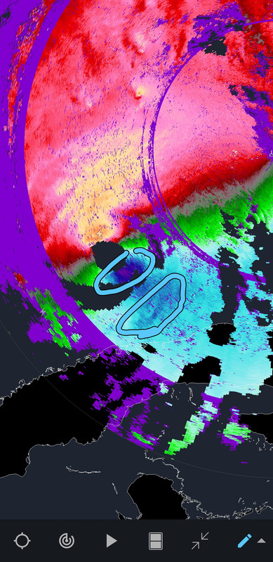
I wonder if we’re about to see an eyewall replacement cycle. Notice the drop in convection on the southern side of the eye.
Velocity can show the beginning of the process better than Reflectivity a lot of the times.
Notice the two different max wind areas on Velocity. It isn't quite as noticeable on the latest scan, but really stood out a bit ago.
Earlier:
This post was edited on 9/27/22 at 2:22 pm

Posted on 9/27/22 at 2:20 pm to LaBR4
I own a lot of property in Sarasota County....I think that area makes it out fine. Most of the older homes are well built
Posted on 9/27/22 at 2:20 pm to PsychTiger
It was splashing that bad with flooding all over that corner and in the streets when we were in Key West in late May and that tropical depression hit.
Posted on 9/27/22 at 2:21 pm to Roll Tide Ravens
quote:
I wonder if we’re about to see an eyewall replacement cycle. Notice the drop in convection on the southern side of the eye.
Possible. 12z HWRF shows kind of a steady state storm before going on another run of intensification tomorrow. An ERC could be one reason for a pause in intensification.
Posted on 9/27/22 at 2:21 pm to OysterPoBoy
quote:
Why is a nautical mile longer than a land mile?
Is it because you have to account for the waves?
A nautical mile takes the curvature of the earth into the calculation.
It is measured at the equator. 360 degrees and 60 minutes in a degree. 1 degree equals one nautical mile.
So the circumference at the equator is 24901 miles or 21600 nautical miles. A knot is nautical miles per hour.
Posted on 9/27/22 at 2:22 pm to Gris Gris
quote:
The tourists are embarrassing and entertaining.
Our unofficial state motto

Posted on 9/27/22 at 2:22 pm to TheOcean
quote:
I own a lot of property in Sarasota County....I think that area makes it out fine. Most of the older homes are well built
Subtle "I'm a slumlord" brag.
Posted on 9/27/22 at 2:24 pm to LegendInMyMind
Those on the SE side of the track keep in mind that an EWRC will temporarily weaken or cap Ian's strengthening, but it will certainly expand the windfield, putting more people at risk of dealing with high winds.
This post was edited on 9/27/22 at 2:25 pm

Posted on 9/27/22 at 2:24 pm to LSUKNUT
New models shifting closer to Port Charlotte

Posted on 9/27/22 at 2:27 pm to Cosmo
Creeping further and further south. Fort Myers is gonna be in the crosshairs if this keeps up

Posted on 9/27/22 at 2:28 pm to Cosmo
quote:
New models shifting closer to Port Charlotte
Can you link?
Posted on 9/27/22 at 2:34 pm to NorthEndZone
Are we going to get the hourly position updated from here on out?

Posted on 9/27/22 at 2:34 pm to LSUFanHouston
quote:
Are we going to get the hourly position updated from here on out?
yep
Posted on 9/27/22 at 2:37 pm to Festus
quote:
Can you link?
Link what?
Posted on 9/27/22 at 2:38 pm to Bobby OG Johnson
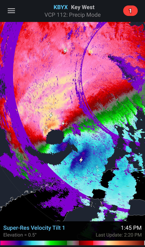
That eye still has a lot of dingleberries around the edge. Clean that sumbitch a little better. 
This post was edited on 9/27/22 at 2:42 pm
Posted on 9/27/22 at 2:39 pm to rds dc
Any chance this thing moves a little faster than the NHC cone says? I really hope it doesn't approach land that slowly, Tampa will be F'd.
Posted on 9/27/22 at 2:40 pm to Oates Mustache
quote:
Link what?
New models shifting closer to Port Charlotte
Posted on 9/27/22 at 2:40 pm to H2O Tiger
Just looking at the radar it definitely looks like it's shifting more and more east. Kinda looking like Cape Coral or Naples to me.
Posted on 9/27/22 at 2:41 pm to Festus
quote:
models


 Page 235 of 465

Popular
Back to top