- My Forums
- Tiger Rant
- LSU Recruiting
- SEC Rant
- Saints Talk
- Pelicans Talk
- More Sports Board
- Fantasy Sports
- Golf Board
- Soccer Board
- O-T Lounge
- Tech Board
- Home/Garden Board
- Outdoor Board
- Health/Fitness Board
- Movie/TV Board
- Book Board
- Music Board
- Political Talk
- Money Talk
- Fark Board
- Gaming Board
- Travel Board
- Food/Drink Board
- Ticket Exchange
- TD Help Board
Customize My Forums- View All Forums
- Show Left Links
- Topic Sort Options
- Trending Topics
- Recent Topics
- Active Topics
Started By
Message

 1
1


Posted on 9/27/22 at 2:00 pm to H2O Tiger
When should things start getting interesting on these webcams?
Posted on 9/27/22 at 2:01 pm to LSUGrrrl
quote:
When should things start getting interesting on these webcams?
It's about 75 miles SSW from the Dry Tortugas, and is moving NNNE (10 degrees) at 10 mph.
This post was edited on 9/27/22 at 2:02 pm
Posted on 9/27/22 at 2:01 pm to H2O Tiger
quote:
Which poster is that out there in his wife beater posing for pictures?
obviously cocomo due to the geography and the sartorial choices
Posted on 9/27/22 at 2:02 pm to LSUGrrrl
quote:
When should things start getting interesting on these webcams?
You gotta give her money first
Oh you mean the hurricane ones? Nvmd
Posted on 9/27/22 at 2:02 pm to VABuckeye
quote:
We haven't left yet but I do have a hotel booked in Miami. The stickler is that we have two 80 lb dogs and it's going to be miserable for us either way. Our street can take up to a 9-10 ft surge before it gets wet. We are forecast for 5-8' which I know is a little close for comfort. My friends across Vanderbilt Beach Rd on the fingers are fricked if it gets to 8'. We will continue to watch the forecast and will make a decision by 7 PM. A northward trend would be good for us but then I feel for those poor people up north. A lot of people are going to get fricked by this storm.
More than likely you are either leaving before the storm or shortly thereafter. Seems a pretty safe bet Naples to St. Pete is going to be out of power for 5-14 days depending on landfall.
And what these storms do at landfall is completely unpredictable. If Ida doesn’t take that hop back east toward New Orleans, the city of New Orleans would have probably come out largely unscathed. On the other hand if Ida had come in east of highway 1 and up into Lafitte, New Orleans would have been absolutely wrecked. And none of that specific path was knowable 6 hours before landfall.

Posted on 9/27/22 at 2:03 pm to LSUGrrrl
quote:
When should things start getting interesting on these webcams?
You mean like this?
Posted on 9/27/22 at 2:03 pm to LSUGrrrl
quote:
When should things start getting interesting on these webcams?
3:50

Posted on 9/27/22 at 2:03 pm to Slagathor
quote:
she's gonna poke someone's eye out with that hiney
mighty fine hiney

Posted on 9/27/22 at 2:04 pm to Roll Tide Ravens
I wonder if we’re about to see an eyewall replacement cycle. Notice the drop in convection on the southern side of the eye.

This post was edited on 9/27/22 at 2:06 pm

Posted on 9/27/22 at 2:06 pm to OldCityGator
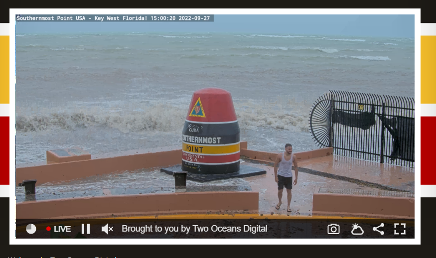
quote:
Key West Southernmost Point Webcam
The tourists are embarrassing and entertaining.

Posted on 9/27/22 at 2:07 pm to OldCityGator
Some idiot was just standing by the tourist marker holding her baby with waves crashing over the wall a few feet away. 
Posted on 9/27/22 at 2:08 pm to Roll Tide Ravens
Pressure still dropping
quote:
000
WTNT64 KNHC 271858
TCUAT4
Hurricane Ian Tropical Cyclone Update
NWS National Hurricane Center Miami FL AL092022
300 PM EDT Tue Sep 27 2022
...3 PM EDT HURRICANE IAN POSITION UPDATE...
Data from an Air Force Reserve Hurricane Hunter aircraft indicate
the minimum pressure has decreased to 952 mb (28.11 in).
SUMMARY OF 300 PM EDT...1900 UTC...INFORMATION
----------------------------------------------
LOCATION...23.7N 83.3W
ABOUT 255 MI...410 KM S OF SARASOTA FLORIDA
ABOUT 75 MI...120 KM SSW OF THE DRY TORTUGAS
MAXIMUM SUSTAINED WINDS...120 MPH...195 KM/H
PRESENT MOVEMENT...N OR 10 DEGREES AT 10 MPH...17 KM/H
MINIMUM CENTRAL PRESSURE...952 MB...28.11 INCHES
$$
Forecaster Reinhart
Posted on 9/27/22 at 2:09 pm to real turf fan
quote:
I can only imagine the man the current gubment will appoint, you won't find a General Honore in charge.
Hunter Biden is on the way.

Posted on 9/27/22 at 2:17 pm to NorthEndZone
This thing is gonna make it to the 930s
Posted on 9/27/22 at 2:17 pm to NorthEndZone


Posted on 9/27/22 at 2:18 pm to real turf fan
quote:
very wet cougars
Sounds kinky
Posted on 9/27/22 at 2:18 pm to NorthEndZone
I’m in The Cape and local forecasters are saying there is another wobble East. Could put The Cape or Ft. Myers right in the crosshairs.
Posted on 9/27/22 at 2:19 pm to PsychTiger
quote:
Some idiot was just standing by the tourist marker holding her baby with waves crashing over the wall a few feet away.
Definitely saw some baws in hawaiian shirts up there earlier

 Page 234 of 465

Popular
Back to top