




 1
1







- My Forums
- Tiger Rant
- LSU Recruiting
- SEC Rant
- Saints Talk
- Pelicans Talk
- More Sports Board
- Fantasy Sports
- Golf Board
- Soccer Board
- O-T Lounge
- Tech Board
- Home/Garden Board
- Outdoor Board
- Health/Fitness Board
- Movie/TV Board
- Book Board
- Music Board
- Political Talk
- Money Talk
- Fark Board
- Gaming Board
- Travel Board
- Food/Drink Board
- Ticket Exchange
- TD Help Board
Customize My Forums- View All Forums
- Show Left Links
- Topic Sort Options
- Trending Topics
- Recent Topics
- Active Topics
Started By
Message
Posted on 10/6/26 at 10:35 am to artompkins
Is it the longer this things takes to develop a center the more west it will shift?
Posted on 10/6/26 at 10:39 am to rds dc

Posted on 10/6/26 at 10:41 am to fightin tigers
quote:
2.2 MMBBLS of refining capacity in that path
And lots of production platforms in the general path. For a storm like this, I doubt they would shut in any production but will have to make some decisions really quickly about sending all employees to land or just non essential.
I would imagine the drill ships will have to disconnect and stop work.
Posted on 10/6/26 at 10:45 am to Dtbtiger
quote:
Id say the closer to the coast for hurricanes, the better. Prairieville seems pretty far from where the need actually would be the most helpful
That was just a picture from a prior trip several years ago. At that point we didnt have what we needed to be truly self sufficient. Since then we have added more supply storage, a refrigerated trailer, a sleeping trailer and water storage in case a location doesnt have running water (running water is still a huge plus if available somewhere).
We also added a second mobile kitchen to double our ability that past spring. But that comes with its own challenges (training a second team of people who can take a week off work with little notice, and raising funds for twice the food purchases. An average single kitchen week long trip runs about $22-$25k.)
But I love doing it and we will respond anywhere there is a need within 8-10 hours from Tuscaloosa.
Posted on 10/6/26 at 10:45 am to lesthemadhatter
quote:
Here is the link to the Google DeepMind weather site. It's cyclone prediction model has it much more east. I believe these models were some of if not the most accurate during last year's hurricane season.
LINK
is there a way to tell when their last model run was?
Posted on 10/6/26 at 10:54 am to alphaandomega
quote:
alphaandomega
Mynegrogif**
Posted on 10/6/26 at 10:58 am to HubbaBubba
quote:
Now showing it as a tropical storm.
So still no hurricanes making landfall in the US the last two years?
Gulf of America putting in work.

Posted on 10/6/26 at 11:03 am to TDsngumbo
quote:
not have homosexual erotic thoughts out loud by OysterPoBoy on my hurricane thread bingo card.
Gonna have to update the card it seems
Posted on 10/6/26 at 11:06 am to deltaland
12Z GFS has the same trend of the 06Z of a messy tropical storm into SE Lousiana.
Posted on 10/6/26 at 11:07 am to waiting4saturday
Not sure. I don't know when they are initializing except maybe at the bottom where you can see the dates and time.
Posted on 10/6/26 at 11:07 am to m57
Yeah, latest GFS doesn't have it into Louisiana until Sunday now
Posted on 10/6/26 at 11:16 am to Lsut81
quote:
Meteorologist Nick Mikulas
17 minutes ago ·
Invest 92L is an interesting one for sure. The track and strength forecast will surely give meteorologists along the Gulf Coast headaches for the next several days. I'll do my best to simplify this and break things down for you in what won't necessarily be a forecast, but a discussion of options on what this thing may do. Here are two of the main scenarios I'm seeing as of now.
Scenario 1.... Strong storm and weaker upper level trough over Texas.
We see this thing ramp up quickly and become a hurricane over the Central Gulf. This would give us a consolidated envelope of moisture around the center, and a system that would respond to deep layer steering currents. A large ridge blocks the eastern escape route across Florida, and the weak trough over Texas helps funnel the storm to the north. As the storm strengthens it would move eastward toward the Central Gulf, then move straight north toward a landfall somewhere between Venice Louisiana and Destin Florida.
Scenario 2.... A weaker storm with a stronger Texas trough.
This is what the GFS and to an extent, the Euro model is showing this morning on the operational runs. The ensembles aren't as on board with this scenario, so I'll say scenario 2 is less likely, though I'm seeing a bit of a trend toward this potential. The interesting thing on this scenario is that a weaker system and stronger trough would pull more moisture toward the northwest, and possibly even pull the track of this system to the northwest as it approaches the coast. In this scenario we could actually see some beneficial rain across the area, but as of now, I think the chance of this is a bit lower.
If I'm putting chances, I'd go 50% on scenario 1, and 30% on scenario 2, with a 20% chance of something different like a much slower moving system, or wind shear just crushing it as it moves northward. Clearly, I'm in the stage where I don't know exact impacts. The good thing I see locally is that in either of the two main possibilities, I don't see us catching a crazy hurricane in our area. A stronger storm would likely go further east, and a weaker storm would likely just bring us the rain we need. DO NOT PLAN ON BENEFICIAL RAIN YET. But I am watching with more interest than I had yesterday. This would likely be a late Friday into Saturday issue wherever things happen. That's not terribly far off. I'll do my best to give more definitive details as we get closer, but as you know, I like to keep things as honest as I can. As soon as I see a significant trend in any direction, I'll be posting about it. See less
Posted on 10/6/26 at 11:22 am to Jim Rockford
Well I do not love that
Posted on 10/6/26 at 11:43 am to Jim Rockford
quote:
Meteorologist Nick Mikulas
Dont know how much I trust this guy….Does his wife have cannons like Fradellas?
Posted on 10/6/26 at 11:45 am to LaBR4
she fine... who is that?
Posted on 10/6/26 at 11:57 am to LegendInMyMind
James Spann X Post
This post was edited on 10/6/26 at 11:59 am
Posted on 10/6/26 at 12:00 pm to soccerfüt

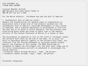
Posted on 10/6/26 at 12:06 pm to lesthemadhatter
Every meteorologist follows a specific model. Spann follows Google Mind, Perillo follows the Euro, others follow GFS or GRAF. It gets really confusing who to trust.

 Page 17 of 18



Popular

Back to top
 Follow TigerDroppings for LSU Football News