




 2
2










- My Forums
- Tiger Rant
- LSU Recruiting
- SEC Rant
- Saints Talk
- Pelicans Talk
- More Sports Board
- Fantasy Sports
- Golf Board
- Soccer Board
- O-T Lounge
- Tech Board
- Home/Garden Board
- Outdoor Board
- Health/Fitness Board
- Movie/TV Board
- Book Board
- Music Board
- Political Talk
- Money Talk
- Fark Board
- Gaming Board
- Travel Board
- Food/Drink Board
- Ticket Exchange
- TD Help Board
Customize My Forums- View All Forums
- Show Left Links
- Topic Sort Options
- Trending Topics
- Recent Topics
- Active Topics
Started By
Message
re: Hurricane Isaias - Pensacola Beach to Navarre Beach Under the Gun
Posted on 10/9/26 at 9:57 am to Funky Tide 8
Posted on 10/9/26 at 9:57 am to Funky Tide 8
quote:
what are the yellow dots and polygons?
Dots are lightning. The polygon is some sort of warning for marine interests.
Posted on 10/9/26 at 9:57 am to LSU=Champions
Forecasting has come a long way I must say.
Posted on 10/9/26 at 9:58 am to NorthEndZone
That's a lot of lightning in the eyewall.
Posted on 10/9/26 at 9:58 am to MasterDigger

Surfs up
OBA
Posted on 10/9/26 at 9:59 am to LegendInMyMind
quote:
The polygon is some sort of warning for marine interests.
If there's any marine vessel out there in that location right now they deserve whatever happens to them.
Posted on 10/9/26 at 10:00 am to TDsngumbo
Winds still at 120 mph on the 10 AM advisory. Pressure 959mb.
Tropical storm warning has been expanded further inland.
Tropical storm warning has been expanded further inland.
Posted on 10/9/26 at 10:00 am to NorthEndZone
From the NHC discussion...not good for power outages farther inland in Alabama. Tree damage will be significant.
quote:
Strong deep-layer shear has definitely increased as forecast, with
various analyses now showing 30-40 kt out of the southwest.
However, the shear vector is nearly aligned with the storm's
motion, which limits its adverse effects, and upper-level
divergence is also increasing over the hurricane. This setup has
likely allowed the hurricane to intensify this morning, and the
hurricane regional models (HAFS-A, HAFS-B, and HWRF), as well as
the statistical-dynamical models (SHIPS and LGEM), all suggest that
Isaias could maintain major hurricane intensity up until its
landfall this evening. Therefore, the NHC official forecast depicts
Isaias with 100-kt winds just offshore the western Florida
Panhandle this evening. Weakening will occur after landfall, but
sustained hurricane-force winds will likely occur near and along
Isaias's track up to 100 miles inland from the coast into southern
Alabama, and gusts to hurricane force could extend even farther
north into central Alabama. Isaias is likely to lose its tropical
characteristics by 36 hours when it is over northern Alabama.
Posted on 10/9/26 at 10:02 am to TDsngumbo
quote:
If there's any marine vessel out there in that location right now they deserve whatever happens to them.
I agree. Kinda like people who buy beachfront property on the Gulf. You can’t possibly be surprised a hurricane may come at you. It’s the reason I decided not to buy a beachfront property. Will rent though.
This post was edited on 10/9/26 at 10:03 am
Posted on 10/9/26 at 10:03 am to Cosmo
quote:
Someone finds out they’re neighbors with another poster in the thread
quote:
Oh yeah, you are less than a mile from me
Yahtzee!
Posted on 10/9/26 at 10:05 am to RockChalkTiger
Pretty notable eastward shift of the cone this close to landfall, especially the western edge of the cone.
Posted on 10/9/26 at 10:05 am to UptownJoeBrown
The intensity shifted a full M closer to land.
Posted on 10/9/26 at 10:05 am to Roll Tide Ravens
quote:
Winds still at 120 mph on the 10 AM advisory. Pressure 959mb.
That is not ideal
Posted on 10/9/26 at 10:06 am to RockChalkTiger
quote:
we’re a few blocks east of J’s Bakery
We lived in Pensacola for five years before moving to Fairhope. I could eat my weight in devil dogs from J’s.
Posted on 10/9/26 at 10:07 am to LegendInMyMind
It’s still going to be a tropical storm almost in Tennessee. That’s amazing
Posted on 10/9/26 at 10:08 am to DomesticatedBoar
Well we lucked out here in NOLA. That looks pretty terrifying. Oof

Posted on 10/9/26 at 10:09 am to MKP2004
quote:
I have a friend who has a beach house on Navarre. He's stressed out of his mind understandably.
I don't understand people like this. I've owned numerous properties in NW Florida over the past 20 years. Some personal residences and most investment. I expect a storm to happen and carry the appropriate insurance to deal with it. I only have one now and its my personal residence for 51% of the year. I drove there Tuesday to pick up the outdoor furniture and drove back to LA. If it gets wiped out, insurance pays for a new and better one.
Posted on 10/9/26 at 10:09 am to lsupride87
I got a feeling that the Tide/Bulldogs game in Tuscaloosa is going to be a shitshow.
Posted on 10/9/26 at 10:09 am to UptownJoeBrown
quote:
I agree. Kinda like people who buy beachfront property on the Gulf. You can’t possibly be surprised a hurricane may come at you. It’s the reason I decided not to buy a beachfront property. Will rent though.
This is exactly why my insurance is so high, along with everyone else who owns on the beach...I got destroyed in Sally and I am grateful that it doesn't look like this will be a repeat for me, but it comes with the territory. You just enjoy the beauty in between the storms.
I do feel sorry for the guys friend though. It is a big lift on the backend to deal with the rebuild coming his way.
Posted on 10/9/26 at 10:09 am to rds dc
Well so much for wind sheer. Now they are talking Cat 4 at landfall.
Posted on 10/9/26 at 10:10 am to fightin tigers
quote:
The posts people had on Monday Google showed into Pascagoula.
It is good, but was it really that much better?
I didn't get a Monday one...I didn't even know it existed

This is from Wednesday 6am.
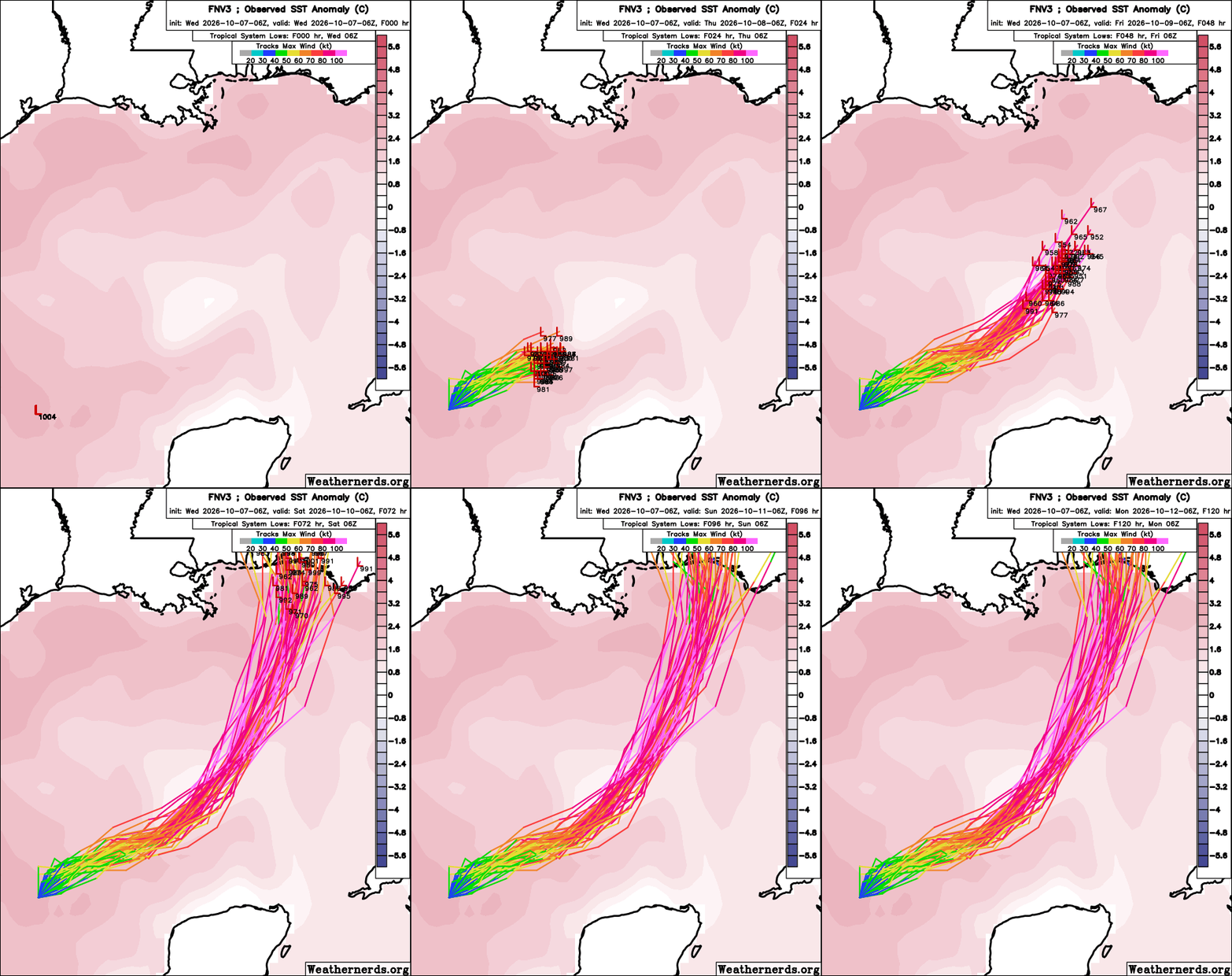
Pretty spot on...taking the center line.

 Page 124 of 128



Popular

Back to top
 Follow TigerDroppings for LSU Football News