- My Forums
- Tiger Rant
- LSU Recruiting
- SEC Rant
- Saints Talk
- Pelicans Talk
- More Sports Board
- Fantasy Sports
- Golf Board
- Soccer Board
- O-T Lounge
- Tech Board
- Home/Garden Board
- Outdoor Board
- Health/Fitness Board
- Movie/TV Board
- Book Board
- Music Board
- Political Talk
- Money Talk
- Fark Board
- Gaming Board
- Travel Board
- Food/Drink Board
- Ticket Exchange
- TD Help Board
Customize My Forums- View All Forums
- Show Left Links
- Topic Sort Options
- Trending Topics
- Recent Topics
- Active Topics
Started By
Message

 1
1

Posted on 9/24/24 at 9:19 pm to James11111
quote:
well that was anti climatic” Pun intended?
Actually no but I’ll pretend I was that clever

Posted on 9/24/24 at 9:21 pm to deltaland
Weather porn from earlier this afternoon


Posted on 9/24/24 at 9:36 pm to deltaland
quote:
My ponds are on Cole Lake Rd outside Isola. I live in Inverness
Tupper Bayou.
Posted on 9/24/24 at 9:44 pm to Bobby OG Johnson

Posted on 9/24/24 at 9:52 pm to RBTiger
Damn she may make hurricane status before morning
Posted on 9/24/24 at 9:55 pm to Bow dude72
Lili and Rita hit during the day iirc.

Posted on 9/24/24 at 9:56 pm to deltaland
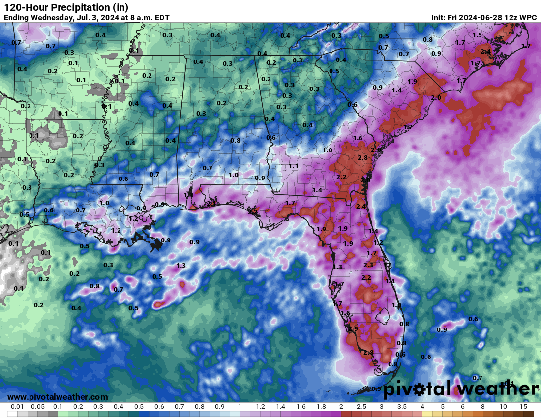
SIAP, 00z WPC 120 hour precipitation.
Posted on 9/24/24 at 9:57 pm to Roll Tide Ravens
Tropical Storm Helene Discussion Number 7
NWS National Hurricane Center Miami FL AL092024
1000 PM CDT Tue Sep 24 2024
Helene continues to become better organized with increased
convective banding features and an overall more symmetrical-looking
cloud pattern. The convection is very deep with cloud tops to -80
deg C or colder. Doppler velocity data from a NOAA Hurricane
Hunter aircraft indicate no significant vertical tilt of the
vortex in the low- to mid-troposphere. This suggests that the
vertical wind shear is low. Earlier flight-level wind data from the
aircraft indicate the the maximum winds are near 50 kt, although
this may be conservative.
Although the storm has been wobbling over the past few hours,
center fixes from the NOAA Hurricane Hunter aircraft indicate a
generally west-northwestward motion at around 300/9 kt. Helene
should turn northwestward soon as a high pressure area over Florida
shifts eastward, with the tropical cyclone center passing near the
northeastern Yucatan Peninsula tomorrow morning. Meanwhile, a
mid-tropospheric trough is digging over the Lower Mississippi
Valley. This evolution of the steering flow should cause Helene to
turn northward with an increase in forward speed during the next day
or so. An accelerating northward to north-northeastward motion over
the eastern Gulf of Mexico should take the system to the
northeastern Gulf of Mexico coast in about 48 hours. After
landfall, Helene should curve cyclonically around a mid-level low
over the south-central United States. The official forecast is very
similar to the previous one and is on top of the latest corrected
consensus track guidance.
Over the next couple of days, Helene will be moving through an
environment of low vertical wind shear, ample environmental
moisture, and over waters of high oceanic heat content. Thus,
significant strengthening is anticipated before landfall on the
northeast Gulf coast. The NHC intensity forecast explicitly shows
steady to rapid intensification (RI) of 25 kt for the next 24 hours
and 30 kt for the 24- to 48-hour forecast interval. This is in
general agreement with the SHIPS RI indices.
Helene is predicted to grow to a very large size in the NHC
forecast. Therefore storm surge, wind, and rainfall impacts will
likely extend well away from the center and outside the forecast
cone, particularly on the east side. In addition, the fast forward
speed while it crosses the coast will likely result in farther
inland penetration of strong winds over parts of the southeastern
United States after landfall.
KEY MESSAGES:
1. Helene is forecast to intensify and be near hurricane strength
when it passes near the northeastern coast of the Yucatan
Peninsula on Wednesday, where a Hurricane Warning is in effect.
2. Helene is expected to rapidly intensify and grow in size over the
eastern Gulf of Mexico. There is a danger of life-threatening storm
surge along the entire west coast of the Florida Peninsula and
Florida Big Bend. The highest inundation levels are
expected along the coast of the Florida Big Bend. Residents in
those areas should follow advice given by local officials and
evacuate if told to do so.
3. Damaging hurricane-force winds are expected along portions of
coast of the Florida Big Bend, where a Hurricane Warning is now in
effect. Preparations to protect life and property should be
complete by early Thursday since tropical storm conditions are
expected to begin within this area on Thursday.
4. Tropical Storm Helene will bring heavy rain to portions of the
western Caribbean with potentially significant flooding across
western Cuba and the northeastern Yucatan Peninsula. Considerable
flash and urban flooding is expected across portions of Florida, the
Southeast, southern Appalachians, and the Tennessee Valley Wednesday
through Friday. This includes the risk of landslides across the
southern Appalachians. Widespread minor to moderate river flooding
is likely, and isolated major river flooding is possible.
FORECAST POSITIONS AND MAX WINDS
INIT 25/0300Z 19.9N 85.5W 50 KT 60 MPH
12H 25/1200Z 21.1N 86.3W 65 KT 75 MPH
24H 26/0000Z 22.7N 86.4W 75 KT 85 MPH
36H 26/1200Z 25.4N 85.5W 90 KT 105 MPH
48H 27/0000Z 29.5N 84.2W 105 KT 120 MPH
60H 27/1200Z 34.0N 84.5W 30 KT 35 MPH
72H 28/0000Z 36.5N 86.5W 20 KT 25 MPH...POST-TROP/INLAND
96H 29/0000Z 37.0N 89.0W 20 KT 25 MPH...POST-TROP/INLAND
120H 30/0000Z...DISSIPATED
Posted on 9/24/24 at 9:58 pm to RBTiger
A slightly more zoomed-in view

Posted on 9/24/24 at 9:59 pm to Roll Tide Ravens
10 PM CDT Advisory.

BULLETIN
Tropical Storm Helene Advisory Number 7
NWS National Hurricane Center Miami FL AL092024
1000 PM CDT Tue Sep 24 2024
...HELENE EXPECTED TO STRENGTHEN RAPIDLY OVER THE GULF OF MEXICO...
SUMMARY OF 1000 PM CDT...0300 UTC...INFORMATION
-----------------------------------------------
LOCATION...19.9N 85.5W
ABOUT 100 MI...160 KM ESE OF COZUMEL MEXICO
ABOUT 145 MI...230 KM SSW OF THE WESTERN TIP OF CUBA
MAXIMUM SUSTAINED WINDS...60 MPH...95 KM/H
PRESENT MOVEMENT...WNW OR 300 DEGREES AT 10 MPH...17 KM/H
MINIMUM CENTRAL PRESSURE...991 MB...29.27 INCHES
FORECAST POSITIONS AND MAX WINDS
INIT 25/0300Z 19.9N 85.5W 50 KT 60 MPH
12H 25/1200Z 21.1N 86.3W 65 KT 75 MPH
24H 26/0000Z 22.7N 86.4W 75 KT 85 MPH
36H 26/1200Z 25.4N 85.5W 90 KT 105 MPH
48H 27/0000Z 29.5N 84.2W 105 KT 120 MPH
60H 27/1200Z 34.0N 84.5W 30 KT 35 MPH
72H 28/0000Z 36.5N 86.5W 20 KT 25 MPH...POST-TROP/INLAND
96H 29/0000Z 37.0N 89.0W 20 KT 25 MPH...POST-TROP/INLAND
120H 30/0000Z...DISSIPATED
Posted on 9/24/24 at 10:02 pm to lsuman25
quote:
The NHC intensity forecast explicitly shows
steady to rapid intensification (RI) of 25 kt for the next 24 hours
and 30 kt for the 24- to 48-hour forecast interval. This is in
general agreement with the SHIPS RI indices.
Not what you want to read given the latest SHIPS guidance.
Posted on 9/24/24 at 10:06 pm to HoLeInOnEr05
quote:
Driving from Huntsville to Asheville Friday should be fun.
I’m driving from Montgomery to Jacksonville Thursday morning……….
Posted on 9/24/24 at 10:08 pm to Roll Tide Ravens
Pretty cool data from the buoy it passed over earlier. It documented some of the upwelling, which was notable even for a storm that isn't quite a hurricane yet.
*I'll post the tweet with the data in the next post.
Loading Twitter/X Embed...
If tweet fails to load, click here. *I'll post the tweet with the data in the next post.
Posted on 9/24/24 at 10:08 pm to LegendInMyMind
Posted on 9/24/24 at 10:10 pm to LegendInMyMind
Did she move east?
Posted on 9/24/24 at 10:14 pm to Roll Tide Ravens
Impressive pops of convection near the center. Looks like convection is starting to wrap around to the western side of the center, which would indicate that Helene continues to get better organized.

Posted on 9/24/24 at 10:14 pm to Bobby OG Johnson
I feel like that gif is the equivalent to when someone in a horror movie looks through the peep hole and the killers eye pops up.
Posted on 9/24/24 at 10:18 pm to NorthEndZone
Current advisory last forecast point before landfall
FORECAST VALID 27/0000Z 29.5N 84.2W
MAX WIND 105 KT...GUSTS 130 KT.
64 KT... 45NE 55SE 20SW 20NW.
50 KT... 70NE 90SE 40SW 40NW.
34 KT...210NE 240SE 140SW 100NW.
The wind field extent is going to be very large if this forecast holds. Those are nautical miles so the statute miles are approximately
Up to ~65 miles in SE quadrant and at least ~25 miles in all directions for hurricane force 74 mph winds (sustained).
Up to ~105 miles in SE quadrant and at least ~45 miles in all directions for 58 mph winds (sustained)
Up to ~275 miles in SE quadrant and at least ~115 miles in all directions for 39 mph winds (sustained)
The links below show the possible extent of the winds.
Tallahassee threats and impacts page
Tampa Threats and Impacts page
This post was edited on 9/24/24 at 10:20 pm
Posted on 9/24/24 at 10:32 pm to Roll Tide Ravens
Hate to say it but she's looking spectacular tonight. Fear what she'll look like tomorrow morning.
Afraid this thing may be a monster. Hope I'm wrong.
Afraid this thing may be a monster. Hope I'm wrong.

 Page 91 of 310

Popular
Back to top