- My Forums
- Tiger Rant
- LSU Recruiting
- SEC Rant
- Saints Talk
- Pelicans Talk
- More Sports Board
- Fantasy Sports
- Golf Board
- Soccer Board
- O-T Lounge
- Tech Board
- Home/Garden Board
- Outdoor Board
- Health/Fitness Board
- Movie/TV Board
- Book Board
- Music Board
- Political Talk
- Money Talk
- Fark Board
- Gaming Board
- Travel Board
- Food/Drink Board
- Ticket Exchange
- TD Help Board
Customize My Forums- View All Forums
- Show Left Links
- Topic Sort Options
- Trending Topics
- Recent Topics
- Active Topics
Started By
Message
re: Helene - Recovery Begins...Devastating Flash Flooding in Western NC and Eastern TN
Posted on 9/26/24 at 9:47 am to BeachDude022

Posted on 9/26/24 at 9:47 am to BeachDude022
I’d imagine a late Friday flight gets cancelled/delayed
Might want to work on a plan B
Might want to work on a plan B
 0
0


Posted on 9/26/24 at 9:48 am to BigBro

Posted on 9/26/24 at 9:48 am to Icansee4miles
Looks like Helene is still struggling to form up the eye. Hopefully this continues and she doesnt get anymore strength before landfall
Posted on 9/26/24 at 9:48 am to Duke
quote:
I am NOT saying this storm will be Michael but I remember a similar fight for him coming in. Until he closed off and went HAM.
I don't remember how fast Michael was moving, but Helene has about 12 - 15 hours left. There is still plenty of time, but every hour that RI is delayed is a bonus.

Posted on 9/26/24 at 9:49 am to BeachDude022
quote:
Think flights out of DFW will be delayed to Nashville tomorrow?
I wouldn't sweat it. Planes can land in rain and a moderate breeze. Nashville is about 500 miles inland by the way the storm will travel.

Posted on 9/26/24 at 9:49 am to rds dc

Posted on 9/26/24 at 9:50 am to IT_Dawg
quote:
Whats their to panic about...drink at the airport until their flights take off. The bachelor flying out 10 hours later anyway
Exactly!
quote:
But good for you. Bachelor weekend in a rain soaked Nashville...them shirts will be see through and they will be ready to party
Posted on 9/26/24 at 9:52 am to Bobby OG Johnson
Center is coming into the view of the Tampa radar site.


Posted on 9/26/24 at 9:53 am to Roll Tide Ravens
kinda looks like Michael, especially with the hot towers blowing up at the end..

This is Michael.
This is Michael.
Posted on 9/26/24 at 9:56 am to rds dc
quote:
I don't remember how fast Michael was moving, but Helene has about 12 - 15 hours left
I cant remember exactly when Michael popped off but it was within 24 hours of landfall. Now, probably not just 12 hours ahead.

Posted on 9/26/24 at 9:59 am to RollTide1987
quote:
So it's tracking more to the east than originally forecasted?
At the moment, yes. But it's still too early to say definitively.
Whether or not that holds and its significance is T.B.D.
Posted on 9/26/24 at 10:01 am to BigBro
10 AM CDT Advisory

BULLETIN
Hurricane Helene Advisory Number 13
NWS National Hurricane Center Miami FL AL092024
1000 AM CDT Thu Sep 26 2024
...HELENE STRENGTHENING AND EXPECTED TO MAKE LANDFALL IN THE
FLORIDA BIG BEND THIS EVENING AS A MAJOR HURRICANE...
...PREPARATIONS TO PROTECT LIFE AND PROPERTY SHOULD BE RUSHED TO
COMPLETION...
SUMMARY OF 1000 AM CDT...1500 UTC...INFORMATION
-----------------------------------------------
LOCATION...25.5N 85.5W
ABOUT 255 MI...405 KM SW OF TAMPA FLORIDA
ABOUT 290 MI...470 KM S OF APALACHICOLA FLORIDA
MAXIMUM SUSTAINED WINDS...105 MPH...165 KM/H
PRESENT MOVEMENT...NNE OR 25 DEGREES AT 14 MPH...22 KM/H
MINIMUM CENTRAL PRESSURE...960 MB...28.35 INCHES
This post was edited on 9/26/24 at 10:03 am
Posted on 9/26/24 at 10:02 am to Mr Breeze
Cat 4 chances have to be dwindling huh?
Posted on 9/26/24 at 10:02 am to Mr Breeze
Seems like the best, least populated area of the Florida coast for a landfall.
Still sucks for people in the path.
Still sucks for people in the path.

Posted on 9/26/24 at 10:05 am to Chad504boy
Also gonna be leaving the loop current shortly. Water still plenty warm but not boiling
Posted on 9/26/24 at 10:07 am to Hobie101

Eye Closed per AF

Posted on 9/26/24 at 10:07 am to Hobie101
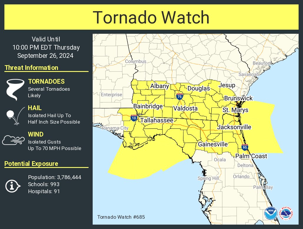
But a ton of rain in Georgia and up into the smokies.
Posted on 9/26/24 at 10:14 am to LSUJuice
quote:
up into the smokies.
Chances the rain will mess up some of the nat parks around westernmost NC? I know they have gotten a good bit of rain there already this year.

 Page 147 of 310

Popular
Back to top