




 0
0








- My Forums
- Tiger Rant
- LSU Recruiting
- SEC Rant
- Saints Talk
- Pelicans Talk
- More Sports Board
- Fantasy Sports
- Golf Board
- Soccer Board
- O-T Lounge
- Tech Board
- Home/Garden Board
- Outdoor Board
- Health/Fitness Board
- Movie/TV Board
- Book Board
- Music Board
- Political Talk
- Money Talk
- Fark Board
- Gaming Board
- Travel Board
- Food/Drink Board
- Ticket Exchange
- TD Help Board
Customize My Forums- View All Forums
- Show Left Links
- Topic Sort Options
- Trending Topics
- Recent Topics
- Active Topics
Started By
Message
re: Harvey ***Catastrophic Flooding Event***
Posted on 8/28/17 at 9:59 am to TinyTigerPaws
Posted on 8/28/17 at 9:59 am to TinyTigerPaws
Idk!! Redstick said that operations were stopped until daylight. Damn shame if he didn't get help but this other chick maybe was providing false info. Poor elderly man ... I work in a nursing home and love my old people.
Posted on 8/28/17 at 9:59 am to ForeverLSU02
quote:
Perkins across from Pennington Biomedical
Are you my attorney

Posted on 8/28/17 at 10:00 am to ForkEmDemons
quote:
Not going to speculate how much.
Posted earlier:
quote:
Out of the 15 USGS stations, only one is showing more than 0.5" up to 9:15.
Posted on 8/28/17 at 10:00 am to X123F45
CIVIL EMERGENCY MESSAGE
HARRIS COUNTY FLOOD CONTROL DISTRICT
RELAYED BY NATIONAL WEATHER SERVICE HOUSTON/GALVESTON TX
957 AM CDT MON AUG 28 2017
THE FOLLOWING MESSAGE IS TRANSMITTED AT THE REQUEST OF THE HARRIS COUNTY FLOOD CONTROL DISTRICT.
THIS IS A VOLUNTARY EVACUATION FOR ALL RESIDENTS IN THE FOLLOWING AREAS OF INVERNESS FOREST SUBDIVISION...ALL STREETS NORTH OF WHITESTONE LANE, INCLUDING EAST AND WEST GREENBROOK DRIVE, AND ALL OF KENCHESTER DRIVE. WATER LEVELS ON CYPRESS CREEK NEAR I-45 WILL POSSIBLY TOP THE LEVEE BY TOMORROW MORNING. RESIDENTS IN THIS AREA ARE ENCOURAGED TO SEEK HIGHER GROUND. FOR MORE INFORMATION, PLEASE CONTACT THE HARRIS COUNTY FLOOD CONTROL DISTRICT AT 713 684 4000
HARRIS COUNTY FLOOD CONTROL DISTRICT
RELAYED BY NATIONAL WEATHER SERVICE HOUSTON/GALVESTON TX
957 AM CDT MON AUG 28 2017
THE FOLLOWING MESSAGE IS TRANSMITTED AT THE REQUEST OF THE HARRIS COUNTY FLOOD CONTROL DISTRICT.
THIS IS A VOLUNTARY EVACUATION FOR ALL RESIDENTS IN THE FOLLOWING AREAS OF INVERNESS FOREST SUBDIVISION...ALL STREETS NORTH OF WHITESTONE LANE, INCLUDING EAST AND WEST GREENBROOK DRIVE, AND ALL OF KENCHESTER DRIVE. WATER LEVELS ON CYPRESS CREEK NEAR I-45 WILL POSSIBLY TOP THE LEVEE BY TOMORROW MORNING. RESIDENTS IN THIS AREA ARE ENCOURAGED TO SEEK HIGHER GROUND. FOR MORE INFORMATION, PLEASE CONTACT THE HARRIS COUNTY FLOOD CONTROL DISTRICT AT 713 684 4000
This post was edited on 8/28/17 at 10:01 am
Posted on 8/28/17 at 10:00 am to GEAUXmedic
Nah, I actually got to do some work.
Just wondered if anyone could answer. I'll go looking after work.
Just wondered if anyone could answer. I'll go looking after work.
Posted on 8/28/17 at 10:01 am to Festus
USGS Precipitation Gauges for Louisiana
Here are all USGS gauges that measure precip in Louisiana. I have them sorted by Parish. Data normally lags by 45 minutes to an hour.
Here are all USGS gauges that measure precip in Louisiana. I have them sorted by Parish. Data normally lags by 45 minutes to an hour.
Posted on 8/28/17 at 10:01 am to GEAUXmedic
Geauxmedic email me autoyesclowntd at gmail
Posted on 8/28/17 at 10:02 am to AutoYes_Clown
half of those spaghetti models on that graphic are complete trash. GFS/EURO/NHC are the only models you need to worry about.
Posted on 8/28/17 at 10:02 am to X123F45
Damn..
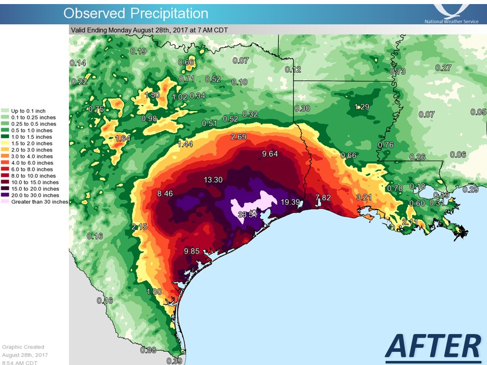
quote:
NWS?Verified account @NWS #Harvey in perspective. So much rain has fallen, we've had to update the color charts on our graphics in order to effectively map it.
Posted on 8/28/17 at 10:02 am to AutoYes_Clown
Any chance this thing shifts further east before landfall?
Posted on 8/28/17 at 10:03 am to LSUengr
nice link. thanks
Posted on 8/28/17 at 10:03 am to AutoYes_Clown
quote:
Geauxmedic email me autoyesclowntd at gmail
Could you ask here? I might not be able to get all if any info you need, and others here might be able to.
eta: and my wife just told me we have to go "run errands". So I'll be MIA for a bit.
This post was edited on 8/28/17 at 10:05 am
Posted on 8/28/17 at 10:04 am to GEAUXmedic
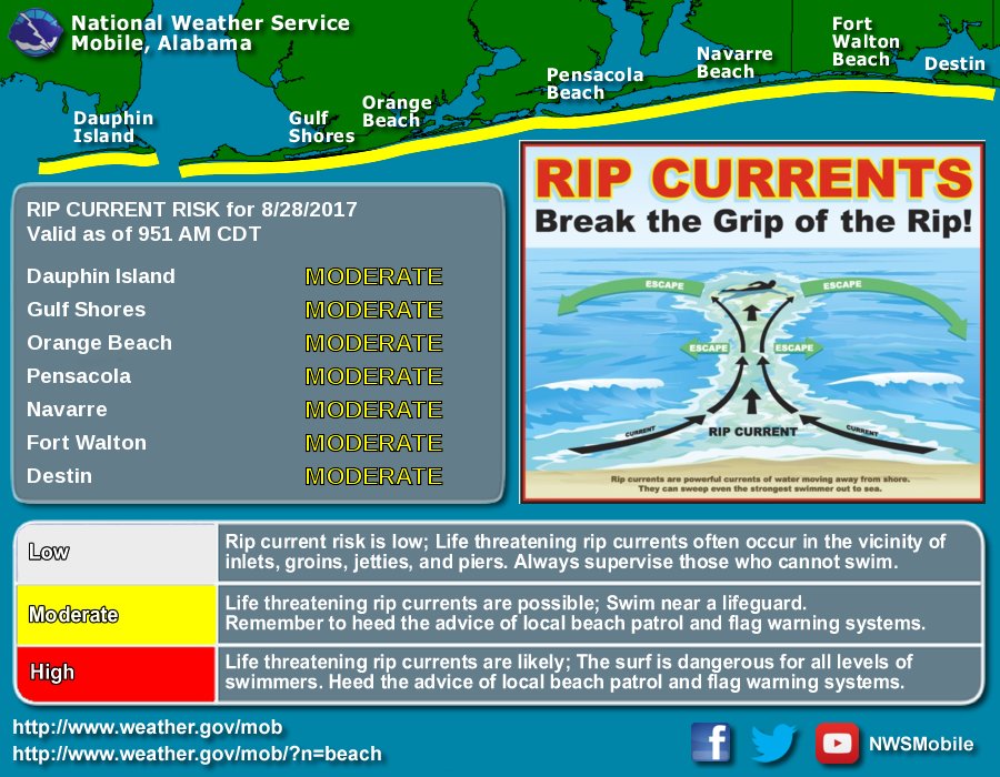
Just a reminder... the effects will be felt farther than Louisiana.
Posted on 8/28/17 at 10:06 am to GEAUXmedic
Anyone familiar with the Natchitoches area an how it handles bit rain events like this?
Posted on 8/28/17 at 10:06 am to CypressTrout10
Posted on 8/28/17 at 10:06 am to GEAUXmedic
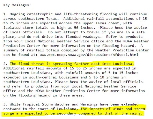
Been raining non-stop in Lafayette since about 5:30 a.m., and it's really pouring hard right now. Until now, it hasn't been the volume of rain that caused last year's flooding, but if this continues, that could change.
Posted on 8/28/17 at 10:07 am to rds dc
I think a Harvey board is an excellent idea. Have stickies in it for rescues, Texas info, and Louisiana info. This thing is going to be around for another week.
Looking at the 10am projection, it looks like it is going to take a pretty good dip into the Gulf.
Looking at the 10am projection, it looks like it is going to take a pretty good dip into the Gulf.
Posted on 8/28/17 at 10:07 am to rds dc
Got a favor to ask, have an 80 yr old family member that needs to be evacuated. They have posted to the Cajun Navy but any additional help would be appreciated. Thanks in advance.

Posted on 8/28/17 at 10:08 am to Festus
quote:
I'm off College and Corporate. Steady rain, but I doubt it's an inch so far.
Try this LINK for hourly, 3 hour, 6 hour, etc observed rain totals. Not necessarily accurate to an isolated area, but a pretty good general measure.
For instance, no parts of Baton Rouge, or the immediately surrounding parishes, received more than an inch from 6 to 9 AM this morning. Local, isolated areas could have gotten more, but nothing widespread.
Posted on 8/28/17 at 10:08 am to LSUengr
There are also a lot of private weather observers that put their data online. There are a few dozen just around the Covington-Mandeville area alone. Now you have to take it with a grain of salt, because you don't know how accurate any one observer's data is, but if you check several in the general area, it will give you a good idea. Google "personal weather station," and the town or zip code you're interest in and several should come up.

 Page 482 of 618


Popular

Back to top
 Follow TigerDroppings for LSU Football News