- My Forums
- Tiger Rant
- LSU Recruiting
- SEC Rant
- Saints Talk
- Pelicans Talk
- More Sports Board
- Fantasy Sports
- Golf Board
- Soccer Board
- O-T Lounge
- Tech Board
- Home/Garden Board
- Outdoor Board
- Health/Fitness Board
- Movie/TV Board
- Book Board
- Music Board
- Political Talk
- Money Talk
- Fark Board
- Gaming Board
- Travel Board
- Food/Drink Board
- Ticket Exchange
- TD Help Board
Customize My Forums- View All Forums
- Show Left Links
- Topic Sort Options
- Trending Topics
- Recent Topics
- Active Topics
Started By
Message

 1
1

Posted on 8/28/23 at 10:00 pm to dukke v
quote:
Still no sticky???? Hhhhmmmm….. Come on admins.. this is gonna be a big deal….
Admins have been slacking lately
No sticky for the hurricane or the UNC Shooting.
And an OT Thread on the Saints Board
They need to be better
This post was edited on 8/28/23 at 10:01 pm
Posted on 8/28/23 at 10:25 pm to LegendInMyMind
quote:
Never trust an "I" storm.
Irma can go pleasure herself.
Posted on 8/28/23 at 10:33 pm to tgrbaitn08
quote:
Admins have been slacking lately No sticky for the hurricane or the UNC Shooting. And an OT Thread on the Saints Board
Not to mention the Georgia fan on the SECrant who started 5 different porn bomb threads that stayed up for almost an hour before getting whacked. A couple of which were tranny porn
Posted on 8/28/23 at 10:36 pm to deltaland
If you were an insurance company and had to chose a landing sport for a major storm in Florida, the center line of that cone would be on the short list of options.
Posted on 8/28/23 at 10:44 pm to Spoonbilla
quote:
Idalia is likely centered just off the western tip of #Cuba
quote:He’s saying he can’t find a “well-defined center of circulation.”
WTF is this "likely" stuff Cowan?
Posted on 8/28/23 at 10:51 pm to LegendInMyMind
quote:
Anyone care to share a link to that Cuban radar?
Might not be as good but free MyRadar picks it up right now off Cuba
Posted on 8/28/23 at 11:00 pm to OU Guy
Man, we really are screwed as a civilization. They think the laser lights are causing the hurricane.
Twitter idiots
Twitter idiots

Posted on 8/28/23 at 11:01 pm to LSURussian
quote:
He’s saying he can’t find a “well-defined center of circulation.”
Yeah I know. I was just being a dick because my 80 year old down the street neighbor was moving his boat to higher ground with the tow cables but forgot to put it on the hitch. That was a sure enough shitshow. We got it done for him and Doctor Cowan will surely get it done for us.
Posted on 8/28/23 at 11:10 pm to OU Guy
Probably just going to check on the storm when the baby wakes me up/in the morning.
Storm still looks pinched to the NW and even to the N. Slow progress until that eases up a little bit. First thing I'm going to check is the WV in the morning, to see if it is starting to breathe to the N.
Storm still looks pinched to the NW and even to the N. Slow progress until that eases up a little bit. First thing I'm going to check is the WV in the morning, to see if it is starting to breathe to the N.
Posted on 8/28/23 at 11:32 pm to Duke
Definitely still fighting some shear right now. That burst on the southern side shows some of that by immediately getting offset to the SE, same thing pinching it to the NW. Could be what is keeping it from wrapping up. Maybe some dry air working in a bit, too.
Posted on 8/28/23 at 11:36 pm to LPLGTiger
quote:
Man, we really are screwed as a civilization. They think the laser lights are causing the hurricane.
They don't understand lightning, the sun, or how shadows work. Amazing, really.
Posted on 8/28/23 at 11:50 pm to LegendInMyMind
This damned moon is going to be our problem in Southern South Carolina. We expect a flood tide already, but who knows what this storm will push in.
This post was edited on 8/28/23 at 11:53 pm
Posted on 8/29/23 at 1:50 am to LPLGTiger
quote:
Man, we really are screwed as a civilization. They think the laser lights are causing the hurricane.
I got up to check out the progress and almost holler-laughed and woke my wife up. That is close to priceless.
Posted on 8/29/23 at 1:58 am to ned nederlander
quote:
If you were an insurance company and had to chose a landing sport for a major storm in Florida, the center line of that cone would be on the short list of options.
2 of the biggest Flood Carriers main offices in the nation are in that cone….
Posted on 8/29/23 at 4:02 am to Dlab2013
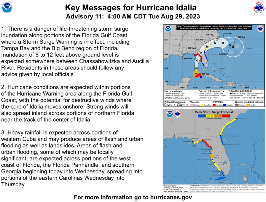
We now have Hurricane Idalia
quote:
Radar data from western Cuba indicates that Idalia is becoming better organized. Most of an eyewall has formed, with much more curvature in the banding features and overall radar pattern. Satellite imagery also shows the center of Idalia firmly within the central dense overcast. Thus, the initial wind speed is raised to 65 kt, in accordance with the latest TAFB satellite classification.
The hurricane is accelerating northward this morning, now moving at about 9 kt. Idalia should move faster to the north or north-northeast through landfall on Wednesday between mid-level ridging over Florida and a trough dropping into the western Gulf of Mexico. There has been a westward shift in the model guidance overnight, perhaps due to the trough tugging Idalia more northward before taking a north-northeast turn. It should be noted that the ECMWF ensemble shows many of its strongest members on the eastern side of its guidance envelope, which is a reasonable place to be given the synoptic pattern. The new NHC forecast is adjusted a little to the west but is now east of the model consensus on the eastern side of the reliable model guidance. After Idalia leaves the eastern United States coastline, the track forecast becomes highly uncertain and little change was made to the previous forecast.
With an inner core now present, the stage is set for Idalia to rapidly intensify before landfall. Shear should continue to lower over the cyclone as an upper-level trough departs the northeastern Gulf of Mexico and ridging builds closer to the cyclone. These changes, combined with extremely warm and deep waters the hurricane will be traversing, all strongly point to rapid intensification. The new forecast is similar to the previous one, and confidence is increasing in an extremely dangerous major hurricane making landfall Wednesday along the west coast or Big Bend region of Florida.
Posted on 8/29/23 at 4:05 am to East Coast Band
Officially a hurricane now
Posted on 8/29/23 at 4:31 am to joshnorris14


Posted on 8/29/23 at 4:44 am to WilWood
quote:
Come on admins.. this is gonna be a big deal….
The folks in the path can now breathe a big sigh of relief
the kiss of death

Posted on 8/29/23 at 4:56 am to Armymann50

 Page 80 of 139

Popular
Back to top