




- My Forums
- Tiger Rant
- LSU Recruiting
- SEC Rant
- Saints Talk
- Pelicans Talk
- More Sports Board
- Fantasy Sports
- Golf Board
- Soccer Board
- O-T Lounge
- Tech Board
- Home/Garden Board
- Outdoor Board
- Health/Fitness Board
- Movie/TV Board
- Book Board
- Music Board
- Political Talk
- Money Talk
- Fark Board
- Gaming Board
- Travel Board
- Food/Drink Board
- Ticket Exchange
- TD Help Board
Customize My Forums- View All Forums
- Show Left Links
- Topic Sort Options
- Trending Topics
- Recent Topics
- Active Topics
Started By
Message

 1
1


Posted on 4/13/19 at 8:46 am to FelicianaTigerfan
quote:
’m trying to push the NAM model on my wife to calm her down. I’m supposed to go to a wedding in Woodville Ms at 6 and she is telling me it’s unsafe.
That's likely to be in the shite of it on the way there and the way back, FYI. It may not be tornadic stuff, but shite weather nonetheless.
Posted on 4/13/19 at 8:48 am to TDsngumbo
quote:
Tell that to folks in Belle Rose, Donaldsonville, and Paincourtville. In the last three years those three cities have been hit by F3 and F2 tornadoes causing major damage.
I think he's talking about the GOM itself, but even then, an F3 went through NO East two years ago.


Posted on 4/13/19 at 8:49 am to Dale Doubak
I’m not an expert but I hav followed this stuff extremely closely for 25 years and I probably know a bit more than the average joe but not nearly as much as a couple others on here.
Having said that, I think the south shore around 4:00 will be fine. Just quite gusty.
Having said that, I think the south shore around 4:00 will be fine. Just quite gusty.
Posted on 4/13/19 at 8:55 am to East Coast Band
quote:
Well, this is strange, the husband trying to talk the wife into going to a wedding when she doesn't want to go.
The groom is a good friend. Most of our wives have backed out so the guys are gonna take one truck. Completely outdoor wedding. We’re gonna bring chainsaws in case of downed trees. Already picked out which suit goes best with Lacrosse rubber boots.
This post was edited on 4/13/19 at 8:58 am
Posted on 4/13/19 at 8:57 am to rds dc
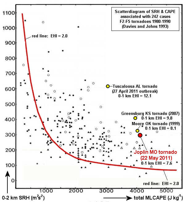
Two frontal boundaries to watch today, one just north of I20 and then a warm front lifting north through S. LA and SE TX. South of WF SPC meso analysis is already showing EHI above 4 across a large area.



Posted on 4/13/19 at 8:59 am to TDsngumbo
I think that people into Alabama, particularly west Alabama, need to really keep a close eye on this. The HRRR shows super cellular/semi-super cellular storms rolling through west Alabama around 3am tomorrow.
This post was edited on 4/13/19 at 9:01 am
Posted on 4/13/19 at 9:01 am to Duke
I have something tonight around 7PM in Baton Rouge. Will it be raining a lot around this time?
Posted on 4/13/19 at 9:05 am to FelicianaTigerfan
We have an outside wedding to attend to today at 3 just outside Baton Rouge. Should be interesting.
Posted on 4/13/19 at 9:07 am to OweO
quote:
I have something tonight around 7PM in Baton Rouge. Will it be raining a lot around this time?
Baton Rouge is in the enhanced risk for severe weather and the NWS in New Orleans has the timing for that area between about 6pm (maybe a little earlier) and midnight.

This post was edited on 4/13/19 at 9:08 am

Posted on 4/13/19 at 9:10 am to Roll Tide Ravens
Thanks. That sucks
Posted on 4/13/19 at 9:10 am to Roll Tide Ravens
My phone was blowing up all night with severe thunderstorm warnings. Quiet now, and overcast. Hopefully the clouds will keep a lid on the daytime heating.


Posted on 4/13/19 at 9:15 am to Jim Rockford
Were in the shite right now but the front is still slowly moving through Abilene.
Nothing too crazy to report but DFW wasn’t in the higher ranges for crazy weather.
Just windy, rainy, and fricking cold atm.
Nothing too crazy to report but DFW wasn’t in the higher ranges for crazy weather.
Just windy, rainy, and fricking cold atm.
Posted on 4/13/19 at 9:21 am to 50_Tiger
Okay I lied. Hail just hit here in Plano
Posted on 4/13/19 at 9:26 am to rds dc
The 12z HRRR and 3k NAM both show storm modes that might some what limit the long track tornado threat. Storms today will have very low bases, be moving very fast with lots of rain and this will make it nearly impossible to see a tornado in advance.
12z HRRR shows discrete storms competing with clusters and line segments, not nearly as ugly as the 00z run.

12z 3k NAM shows storms building upscale into a couple of lines.

All modes of svr wx will be possible and both models show plenty of rotating updrafts. Convective evolution is hard for the models to pin down but trends, at this time, seem to be away from long track supercells.
12z HRRR shows discrete storms competing with clusters and line segments, not nearly as ugly as the 00z run.
12z 3k NAM shows storms building upscale into a couple of lines.
All modes of svr wx will be possible and both models show plenty of rotating updrafts. Convective evolution is hard for the models to pin down but trends, at this time, seem to be away from long track supercells.

Posted on 4/13/19 at 9:26 am to Roll Tide Ravens
Certainly good timing, typically, for weakening storms, but terrible timing for those to get prepared.
May need to advise folks to nap this afternoon prior to arrival
May need to advise folks to nap this afternoon prior to arrival
Posted on 4/13/19 at 9:27 am to 50_Tiger
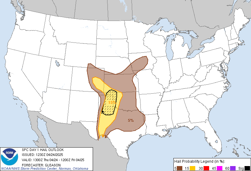
Interesting - DFW was 'only' in the 15% hail area.
Posted on 4/13/19 at 9:36 am to rds dc
quote:
Convective evolution is hard for the models to pin down but trends, at this time, seem to be away from long track supercells
That's good news, no doubt.
ETA - 13z HRRR is trending back to more discrete cells in LA, but it's an outlier so far.
This post was edited on 4/13/19 at 9:42 am
Posted on 4/13/19 at 9:37 am to NorthEndZone
Yeah it was about dime size. Happened for about 3-5 minutes

Posted on 4/13/19 at 9:40 am to Roll Tide Ravens
What about the east central Mississippi area from, say, Philadelphia going north to Columbus? FYI, in the Golden Triangle area it's cool (actually kind of chilly) with steady rain/clouds since last night. Though, I know that doesn't mean jack in the big scheme of things, and I'm praying that the sun doesn't pop out or that the air doesn't start turning soupy.
We have a really good meteorologist on our local channel, and last night his sentiment was the same as most good meteorologists, i.e., waiting to see how things shake out.
However, he had some sort of model that forecasted probable areas where high risk/ discrete supercell/ tornadic storms could form and it was not looking good for the area if the models wound up being right. I may not be remembering it right, but basically the model was showing what we don't want to see, probability wise.
I'm not in the mood to dodge meat grinders all day and night, and they love to touch down in this part of the world.
We have a really good meteorologist on our local channel, and last night his sentiment was the same as most good meteorologists, i.e., waiting to see how things shake out.
However, he had some sort of model that forecasted probable areas where high risk/ discrete supercell/ tornadic storms could form and it was not looking good for the area if the models wound up being right. I may not be remembering it right, but basically the model was showing what we don't want to see, probability wise.
I'm not in the mood to dodge meat grinders all day and night, and they love to touch down in this part of the world.

 Page 17 of 47

Popular
Back to top
 Follow TigerDroppings for LSU Football News