




- My Forums
- Tiger Rant
- LSU Recruiting
- SEC Rant
- Saints Talk
- Pelicans Talk
- More Sports Board
- Fantasy Sports
- Golf Board
- Soccer Board
- O-T Lounge
- Tech Board
- Home/Garden Board
- Outdoor Board
- Health/Fitness Board
- Movie/TV Board
- Book Board
- Music Board
- Political Talk
- Money Talk
- Fark Board
- Gaming Board
- Travel Board
- Food/Drink Board
- Ticket Exchange
- TD Help Board
Customize My Forums- View All Forums
- Show Left Links
- Topic Sort Options
- Trending Topics
- Recent Topics
- Active Topics
Started By
Message
re: Weather Board: Enhanced (3 out of 5) Risk for Yankees This PM. Tornado Watch For Masters
Posted on 4/13/19 at 7:32 am to OGtigerfan87

Posted on 4/13/19 at 7:32 am to OGtigerfan87
Leave and go where?
This post was edited on 4/13/19 at 7:33 am
 2
2

Posted on 4/13/19 at 7:36 am to Duke
(no message)
This post was edited on 11/8/20 at 6:09 am
Posted on 4/13/19 at 7:45 am to willeaux
Oh last night I was posting that we were thinking about going and staying in Conway Arkansas last night to avoid most of the storm. It’s about 3 hrs north if we are leaving we are leaving in the next hour

Posted on 4/13/19 at 7:47 am to OGtigerfan87
quote:
Oh last night I was posting that we were thinking about going and staying in Conway Arkansas last night to avoid most of the storm. It’s about 3 hrs north if we are leaving we are leaving in the next hour
If you've got a well built home, you're incredibly likely to be okay. Just be aware of the situation.
Posted on 4/13/19 at 7:56 am to willeaux
Most recent run of the HRRR seems to be much more subdued than some of the overnight runs. Still plenty of updrafts though, so I guess we'll see.

Posted on 4/13/19 at 8:05 am to slackster
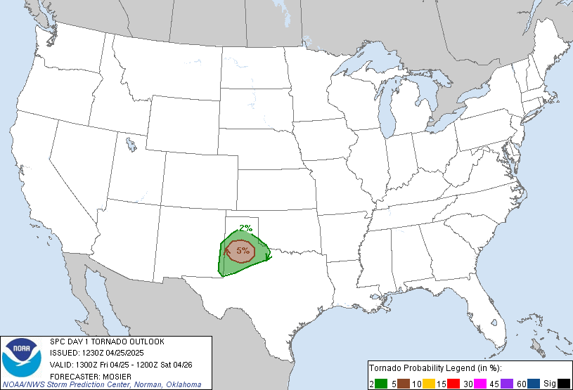
Updated tornado outlook. Discussion talks about the uncertainty that remains over how discrete cells will be.
quote:
...TX to Lower Mississippi Valley, Mid-South and TN Valley...
A regional outbreak of severe thunderstorms, with the main concern being damaging tornadoes, still appears possible today in and near the categorical moderate-risk area. Only peripheral adjustments were needed for this outlook package, based on convective trends this morning and (on the eastern edge) continuity of overnight severe potential into the early day-2 period.
Strong-severe thunderstorms are ongoing across portions of the Hill Country southward toward the Rio Grande. This convection will pose a severe threat into central TX through the rest of the morning. Refer to SPC watches 48-49 and associated mesoscale discussions for near-term details. East of the ongoing activity, the parameter space will become very supportive of supercell/tornado potential through the day in the warm sector, with the main uncertainties being longevity and discreteness of favorable storm mode.
As the southern front moves farther inland, a deeply moist boundary layer will spread across the region, with surface dew points commonly in the mid/upper 60s F and locally near 70, PW 1.5-1.75 inches, and mean mixing ratios increasing to 15-16 g/kg, with forecast soundings showing favorably low LCL. Gradual diabatic heating in pockets will weaken already meager MLCINH from midmorning onward, enabling storm formation on pre-MCS sources for weak lift such as confluence/convergence lines, and perhaps persistent/relatively deep horizontal convective rolls. Lapse rates will strengthen with westward extent, supporting preconvective MLCAPE ranging from 2000-3000 J/kg over parts of east TX to 1000-2000 J/kg over portions of LA and MS. Such buoyancy will be more than favorable for all forms of severe, amidst strengthening deep shear related to the approach of the mid/upper trough.
This post was edited on 4/13/19 at 8:13 am
Posted on 4/13/19 at 8:05 am to slackster
Is the model still pushing the worst stuff south?
Posted on 4/13/19 at 8:08 am to slackster
We are at my parents house it is a brink and mortar house but has several rooms with almost floor to wall windows so I’m not sure that is good. It has never sustained any noticeable damage and it was built a while before I was born and I’m 31 so it’s probably fairly sturdy
This post was edited on 4/13/19 at 8:31 am


Posted on 4/13/19 at 8:10 am to OGtigerfan87
Stay safe down there today baws.
Posted on 4/13/19 at 8:16 am to OGtigerfan87
quote:
Is the model still pushing the worst stuff south?
You're going to get shitty, severe weather in Oak Grove. I don't think you should evacuate unless you think you're in an unsafe situation, and it doesn't sound like you are.

Posted on 4/13/19 at 8:36 am to rds dc
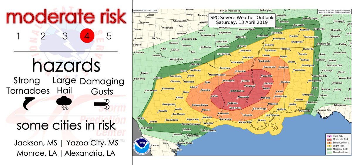
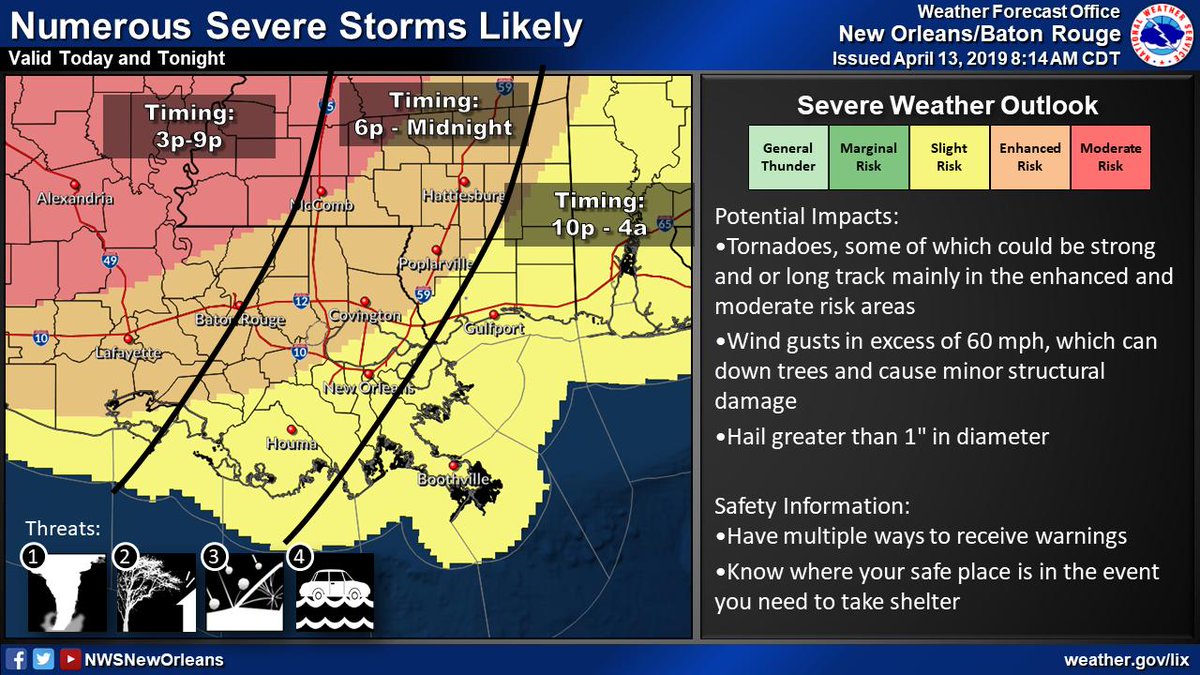
I am not as concerned with areas closer to the Gulf (Lafayette, Lake Charles, etc.) because significant tornadoes do not often occur that close to the water (air is often too stable). Where I am concerned more are the areas around Alexandria, Natchitoches, Jena, Marksville, etc. The wind shear profile looks to be more favorable in the middle part of the state. Shreveport and Monroe are still under the gun, but I am more concerned with an EF-2 or greater tornado to occur south of Shreveport and north of Opelousas.
The cells that develop out in front of the main line to come later this evening are the ones to watch for significant hail or tornadoes. Spinups may occur on the main line itself, but those will not be as significant as tornadoes that form from individual, isolated cells.
The cells that develop out in front of the main line to come later this evening are the ones to watch for significant hail or tornadoes. Spinups may occur on the main line itself, but those will not be as significant as tornadoes that form from individual, isolated cells.
This post was edited on 4/13/19 at 8:42 am
Posted on 4/13/19 at 8:41 am to slackster
I’m trying to push the NAM model on my wife to calm her down. I’m supposed to go to a wedding in Woodville Ms at 6 and she is telling me it’s unsafe.
Posted on 4/13/19 at 8:41 am to slackster
Yeah I’ve kinda come to that conclusion. On the other hand a quick road trip somewhere north doesn’t hurt anything and at the very worst it is a small inconvenience so I’m torn
This post was edited on 4/13/19 at 8:44 am
Posted on 4/13/19 at 8:43 am to FelicianaTigerfan
quote:
I’m supposed to go to a wedding in Woodville Ms at 6
That is an area I am especially concerned about being at risk for severe weather, especially around that time. I hope it's indoors.
quote:
On the other hand a quick road trip somewhere north doesn’t hurt anything and at the very knits is a small inconvenience so I’m torn
I wouldn't evacuate for this weather. It's not like a hurricane where widespread devastation can be forecasted. Just have a plan in place of where you will go if a tornado happens to be in your path. The odds of a tornado hitting your home are smaller than most people think. It's best to have as many walls between you and outside as possible (like a bathroom, closet, or under a stairwell. No basements in LA unfortunately).
This post was edited on 4/13/19 at 8:46 am


Posted on 4/13/19 at 8:43 am to FelicianaTigerfan
quote:
I’m supposed to go to a wedding in Woodville Ms at 6 and she is telling me it’s unsafe.
Well, this is strange, the husband trying to talk the wife into going to a wedding when she doesn't want to go.


Posted on 4/13/19 at 8:43 am to schwartzy
quote:
significant tornadoes do not often occur that close to the water
Tell that to folks in Belle Rose, Donaldsonville, and Paincourtville. In the last three years those three cities have been hit by F3 and F2 tornadoes causing major damage.
Posted on 4/13/19 at 8:45 am to East Coast Band
Must be an open bar lol
Posted on 4/13/19 at 8:45 am to FelicianaTigerfan
I would not go to Woodville at 6 if I didn’t have to. They’re under a significant risk at that time.

 Page 16 of 47

Popular
Back to top
 Follow TigerDroppings for LSU Football News