- My Forums
- Tiger Rant
- LSU Recruiting
- SEC Rant
- Saints Talk
- Pelicans Talk
- More Sports Board
- Fantasy Sports
- Golf Board
- Soccer Board
- O-T Lounge
- Tech Board
- Home/Garden Board
- Outdoor Board
- Health/Fitness Board
- Movie/TV Board
- Book Board
- Music Board
- Political Talk
- Money Talk
- Fark Board
- Gaming Board
- Travel Board
- Food/Drink Board
- Ticket Exchange
- TD Help Board
Customize My Forums- View All Forums
- Show Left Links
- Topic Sort Options
- Trending Topics
- Recent Topics
- Active Topics
Started By
Message
re: Tuesday Severe weather for the Gulf Coast/Snowstorm for Arkansas
Posted on 1/23/23 at 5:33 pm to RBTiger
Posted on 1/23/23 at 5:33 pm to RBTiger
quote:
HIGH WIND WATCH in Effect too...South Wind 30-40mph ...Gust 50mph?
Kinda funny that an area that is in an Enhanced risk with a 30% chance of severe winds has a Wind Warning issued with gust potential under the severe threshold.
This post was edited on 1/23/23 at 5:34 pm
 1
1


Posted on 1/23/23 at 5:45 pm to The Boat
quote:
I thought each caption was pretty easy to follow even for a laid person but I digest.
Are you trying to say that the majority of the OT doesn't get laid? Not a bad surmise probably.
Posted on 1/23/23 at 5:50 pm to LegendInMyMind
quote:
Kinda funny that an area that is in an Enhanced risk with a 30% chance of severe winds has a Wind Warning issued with gust potential under the severe threshold.
was reading the NO NWS discussion.
quote:
There is an Enhanced Risk of Severe Weather (3/5) for Tues night into Wed morning.
-A few brief, spin-up tornadoes will be possible
-potential for damaging winds (60+mph)
-large hail
Mainly along and south of I-10/I-12 corridor.
a few brief spin up tornadoes, yet we are in hatched enhanced
I get it, but man sometimes the forecasters need to use better language .

Posted on 1/23/23 at 6:23 pm to gaetti15


Posted on 1/23/23 at 6:30 pm to LaBR4

Posted on 1/23/23 at 6:42 pm to The Boat
tBoat......you can learn a thing or two about a thing or two from Brandon Black.
If "beyond bonkers" works for a NWS discussion, it'll do for the OT.
If "beyond bonkers" works for a NWS discussion, it'll do for the OT.

Posted on 1/23/23 at 6:45 pm to LegendInMyMind
I’ve got plenty of forecaster’s discussion writing ;)
I like guys like that with a little flair.
I like guys like that with a little flair.
Posted on 1/23/23 at 6:48 pm to The Boat
quote:
like guys like that with a little flair.
I forgot which one I read in Alaska earlier last year, but it had a lord of the rings theme to it...and it was hilarious
Posted on 1/23/23 at 6:52 pm to The Boat
Brandon is damn good. He's also one of the only ones who will postmortem his work for all the world to see.

Posted on 1/23/23 at 7:25 pm to The Boat
Timing for SELA tomorrow?
Posted on 1/23/23 at 7:47 pm to Bayou_Tiger_225
quote:
Timing for SELA tomorrow?
From NO NWS at 330pm
Regarding the timing, this will generally be an evening and overnight event. Main timing for
-Baton Rouge and west 6p-12a
-southshore & northshore & S MS 8p-2a
-MS Coast 12a-5a.

Posted on 1/23/23 at 8:23 pm to gaetti15
When does global warming start?
Posted on 1/23/23 at 8:28 pm to LegendInMyMind
quote:
If "beyond bonkers" works for a NWS discussion, it'll do for the OT.
Sounds like they’re letting Prince Harry write the forecast discussion.
Posted on 1/23/23 at 8:37 pm to The Boat
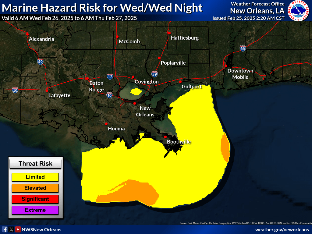
In case you haven't heard, don't go out on the water tomorrow anywhere along the western and northern Gulf coast or in any body of water.
URGENT - MARINE WEATHER MESSAGE
National Weather Service New Orleans LA
650 PM CST Mon Jan 23 2023
Coastal Waters from Port Fourchon LA to Lower Atchafalaya River
LA out 20 nm-
Coastal waters from the Southwest Pass of the Mississippi River
to Port Fourchon Louisiana out 20 NM-
Coastal waters from Port Fourchon Louisiana to Lower Atchafalaya
River LA from 20 to 60 NM-
Coastal waters from Southwest Pass of the Mississippi River to
Port Fourchon Louisiana from 20 to 60 NM-
Coastal Waters from Stake Island LA to Southwest Pass of the
Mississippi River from 20 to 60 nm-
Coastal waters from Pascagoula Mississippi to Stake Island
Louisiana out 20 to 60 NM-
...STORM WARNING IN EFFECT FROM 3 PM TUESDAY TO 3 AM CST
WEDNESDAY...
WHAT...East to southeast winds 15 to 25 kt with gusts up to 35
kt expected through Tuesday afternoon. Late Tuesday afternoon
through Tuesday night south to southeast winds 25 to 40 kt with
gusts up to 50 kt. Wednesday morning through Thursday morning
west to northwest winds 15 to 25 kt gusts up to 35 kt. Seas 6 to
10 ft ramping up to 10 to 17 ft Tuesday Night then backing down
to 6 to 10 ft Wednesday and Wednesday night.
This post was edited on 1/23/23 at 8:41 pm

Posted on 1/23/23 at 8:38 pm to gaetti15
quote:
southshore & northshore & S MS 8p-2a
I fricking hate night storms.
Posted on 1/23/23 at 8:39 pm to gaetti15
quote:

quote:
Timing for SELA tomorrow?
From NO NWS at 330pm
Regarding the timing, this will generally be an evening and overnight event. Main timing for
-Baton Rouge and west 6p-12a
-southshore & northshore & S MS 8p-2a
-MS Coast 12a-5a.
Posted on 1/23/23 at 9:01 pm to NorthEndZone
That LLJ just fricking cranks as the system progresses Eastward tomorrow.
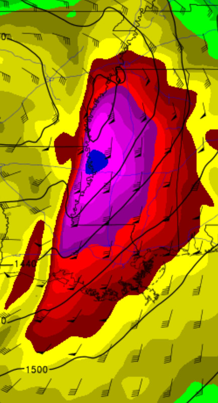
Really good thing that this is January and we're dealing with a postage stamp sized warm sector and minimal moisture return. If this were April, we'd all have problems and this would be a very different thread.
That's the 00z NAM 850mb winds at around 9pm tomorrow.
Really good thing that this is January and we're dealing with a postage stamp sized warm sector and minimal moisture return. If this were April, we'd all have problems and this would be a very different thread.
That's the 00z NAM 850mb winds at around 9pm tomorrow.
Posted on 1/23/23 at 9:31 pm to Bayou_Tiger_225
quote:
Timing for SELA tomorrow?
This is just one run from one model but a decent frame of reference
3 pm:

6 pm:

9 pm:

Midnight:

Posted on 1/23/23 at 10:28 pm to LegendInMyMind
quote:
Really good thing that this is January and we're dealing with a postage stamp sized warm sector and minimal moisture return. If this were April, we'd all have problems and this would be a very different thread.
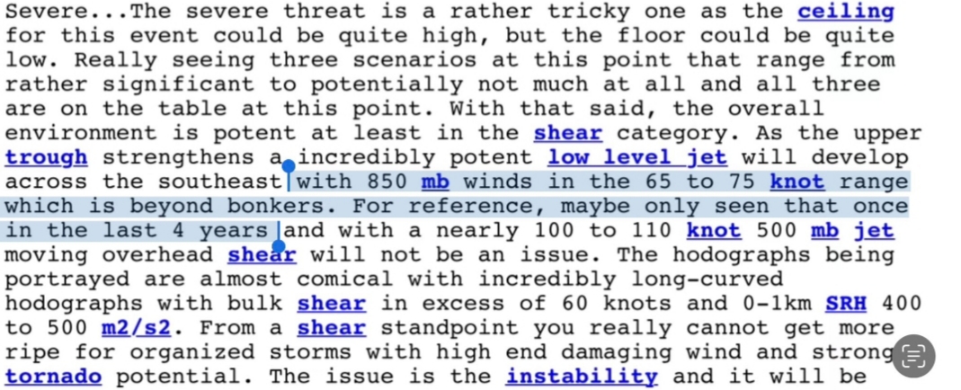
Last time I remember seeing bulk shear and SRH numbers that high was back on 4/27/2011.
You are correct. Just some modest instability would be bad news.
Posted on 1/23/23 at 11:08 pm to tiggerfan02 2021
Heads up to any folks South of Houston or between Houston and Galveston. Things have only trended up for that area over the past 24 hours. There's a small area with a volatile environment over that area. Anything that can get going will pose a serious tornado risk. It'll likely be a messy storm mode and storms will be moving quickly. Just keep an eye out if traveling, especially.

 Page 4 of 28

Popular
Back to top