




- My Forums
- Tiger Rant
- LSU Recruiting
- SEC Rant
- Saints Talk
- Pelicans Talk
- More Sports Board
- Fantasy Sports
- Golf Board
- Soccer Board
- O-T Lounge
- Tech Board
- Home/Garden Board
- Outdoor Board
- Health/Fitness Board
- Movie/TV Board
- Book Board
- Music Board
- Political Talk
- Money Talk
- Fark Board
- Gaming Board
- Travel Board
- Food/Drink Board
- Ticket Exchange
- TD Help Board
Customize My Forums- View All Forums
- Show Left Links
- Topic Sort Options
- Trending Topics
- Recent Topics
- Active Topics
Started By
Message
re: Storm Tracking: Bertha - It's Over
Posted on 7/19/26 at 10:29 pm to SpotCheckBilly

Posted on 7/19/26 at 10:29 pm to SpotCheckBilly
quote:
My grandparents lived in south Florida. The local paper would print a two-page map of the Gulf and Caribbean. They would cut out the map (surrounded by ads from local businesses), mount it on a piece of cardboard, and stick pins in the map to plot the approximate course of disturbances they heard about from ships that came into the port at Ft. Lauderdale. I still have one of the maps from the 40s or 50s. They also watched the birds and saw how other animals were acting.
I can remember when TV stations would print Hurricane Guides with ads and a booklet of information.
My only gripe on the charts is that it becomes like a game. The meteorologists give you the coordinates that you see on TV and you play along by plotting the storm on a paper map that you have folded up or you put on a push pin board.
Now you can see all this information on your phone and then some.
The cool thing about the maps was the genius of having ads on them and having them at a specific store or restaurant. Great marketing move. Now it doesn’t even pay to do these things as no one does anything in print like this.
 4
4


Posted on 7/19/26 at 10:42 pm to Tarps99
I remember my dad doing them every year when I was a kid and he would pick a different color pencil for every storm.


Posted on 7/19/26 at 10:52 pm to LSUDUCKMAN67
We sailed out of New Orleans this afternoon. Just left the Southwest Pass and entered open waters probably about 30 minutes ago. Scheduled to dock in Key West Tuesday morning.
What should I expect weather wise?
What should I expect weather wise?
This post was edited on 7/19/26 at 10:56 pm

Posted on 7/19/26 at 11:05 pm to Darth_Vader
Looks like it skims New Orleans. Going in for direct hit at San Antonio Texas.
Posted on 7/19/26 at 11:10 pm to LivingstonLaw
I see some thunderstorms north of us. From what I see on future radar, I think we’ll have some bands of rain later. Wonder if we’ll hit rough seas?
Posted on 7/19/26 at 11:27 pm to Macintosh
Millibars have slightly dropped to 1008. Wouldn't surprise me to see this become Bertha sometime tomorrow afternoon.
But she will battle dry air and shear ; hopefully keeping heavier rains over the coastal waters
Storms are firing near the center of circulation the past couple hours
Some nasty storms raced across the Chandelier Islands earlier ; wonder if there were a few "Water Spouts"?

But she will battle dry air and shear ; hopefully keeping heavier rains over the coastal waters
Storms are firing near the center of circulation the past couple hours
Some nasty storms raced across the Chandelier Islands earlier ; wonder if there were a few "Water Spouts"?

Posted on 7/19/26 at 11:37 pm to Spocks Brain
quote:
Member since Nov 2025 so yes first hurricane thread.
Then break out the titty milk ... It's gonna get fun
Posted on 7/19/26 at 11:51 pm to Darth_Vader
quote:
Just left the Southwest Pass and entered open waters probably about 30 minutes ago. Scheduled to dock in Key West Tuesday morning.
15 knot avg for 35 hours. In a Viking 60' maybe. Actually made that trip in a sport fisher in a shade under 24 hours a few years ago. Open gulf water at 25 knots for a full day will make you miss a root canal
quote:
What should I expect weather wise?
A few showers and a nice leisurely broad reach ending when you run aground on Galveston on Friday
This post was edited on 7/19/26 at 11:57 pm


Posted on 7/20/26 at 6:23 am to LivingstonLaw
quote:
Going in for direct hit at San Antonio Texas.
Geography much?


Posted on 7/20/26 at 6:26 am to udtiger
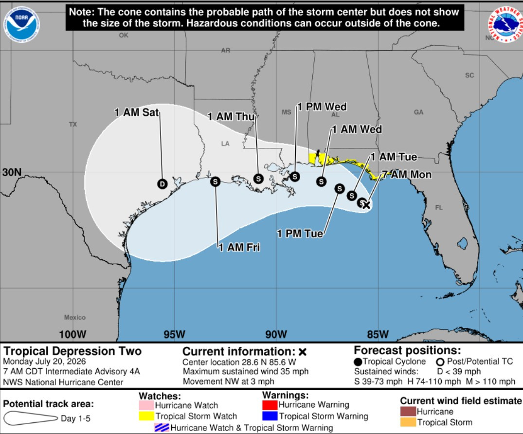
Am I correct that the track moved farther north while I slept?


Posted on 7/20/26 at 6:27 am to Tarps99
Every time we have a legit hurricane threat, I print one and plot it every time a new advisory comes out. I love tracking them on satellite and radar but nothing beats printing a map and plotting the coordinates once one gets close. I love to do my best at drawing the projected path at landfall then comparing the actual coordinates of the center to see how it deviated from the forecast path. Tracking Laura was really fun and tracking Ida was intense since it came right over us. Did the same for Francine which was fun too.
This post was edited on 7/20/26 at 6:30 am
Posted on 7/20/26 at 6:27 am to Obtuse1
quote:
Am I correct that the track moved farther north while I slept?
Yes.
Looks more like the initial guidance when it was named a depression
Posted on 7/20/26 at 6:30 am to Tarps99
That K&B map takes me back. Thanks
Posted on 7/20/26 at 6:34 am to UptownJoeBrown
quote:
That K&B map
Nash Roberts had us all tuned in to what was going on and doing our own tracking with that K&B map

Posted on 7/20/26 at 6:35 am to Obtuse1
quote:
Am I correct that the track moved farther north while I slept
About 3/4 of an S north.
This post was edited on 7/20/26 at 6:36 am
Posted on 7/20/26 at 6:41 am to Spocks Brain
quote:
You guys want to stick to the topic at hand please? What’s the latest?
Ehh, they are sticking to the topic. Future Punta Cana vacations depend on these threads.

Posted on 7/20/26 at 6:52 am to HouseMom
Posted on 7/20/26 at 6:58 am to rds dc
quote:
I guess it's possible, but the system would have to rapidly organize over the next 24 hours. Then, a deeper, more organized system probably takes on a more SW motion, and may miss Louisiana to the south before heading towards Texas. However, dry air and northerly shear over the next couple of days probably result in more slow, steady organization than rapid organization.
As expected, dry air & shear are winning out. It still has time over warm water, so we'll see what happens.
Posted on 7/20/26 at 7:09 am to rds dc
Supposed to land at MSY on Wednesday at 4:35PM. Think there will be any issues?

Posted on 7/20/26 at 7:28 am to Ziggy
depends on your pilot I suppose

 Page 12 of 38

Popular
Back to top
 Follow TigerDroppings for LSU Football News