- My Forums
- Tiger Rant
- LSU Recruiting
- SEC Rant
- Saints Talk
- Pelicans Talk
- More Sports Board
- Fantasy Sports
- Golf Board
- Soccer Board
- O-T Lounge
- Tech Board
- Home/Garden Board
- Outdoor Board
- Health/Fitness Board
- Movie/TV Board
- Book Board
- Music Board
- Political Talk
- Money Talk
- Fark Board
- Gaming Board
- Travel Board
- Food/Drink Board
- Ticket Exchange
- TD Help Board
Customize My Forums- View All Forums
- Show Left Links
- Topic Sort Options
- Trending Topics
- Recent Topics
- Active Topics
Started By
Message
 1
1

Posted on 3/4/25 at 4:28 pm to Mr Roboto

Posted on 3/4/25 at 4:32 pm to deltaland
quote:watching the news now and either the weather station is getting very bad data or Laurel is about to have a hurricane pass through tonight
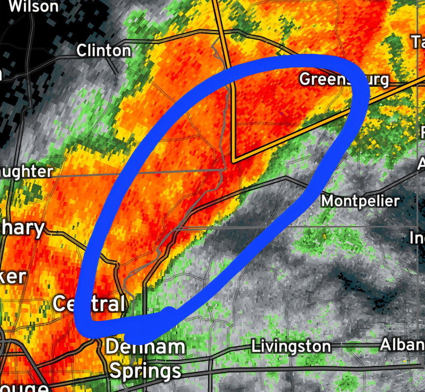
Those discrete cells forming in south ms are going to be a problem.
Right about the time they get to Bassfield and Laurel
Posted on 3/4/25 at 4:34 pm to Who_Dat_Tiger
Whole lot of nothing at my place in BR. A little wind maybe 1” rain. Sun trying to come out now
Posted on 3/4/25 at 4:36 pm to HighRoller
Glad to hear that for the baseball game tonight. I’ll be tuning in as long as I have power. It’s already flickered off here and lost internet for the time being til the modem boots back up
Posted on 3/4/25 at 4:39 pm to HighRoller
Exactly whole lot of nuffon in BR

Posted on 3/4/25 at 4:42 pm to ellesssuuu
Deluge for about 5 minutes with some sideways rain.
Every
fricking
Time
I
Pick
Up
My
"Loose"
Items
Every
fricking
Time
I
Pick
Up
My
"Loose"
Items
This post was edited on 3/4/25 at 4:57 pm
Posted on 3/4/25 at 4:43 pm to ellesssuuu
quote:
Exactly whole lot of nuffon in BR
Would you like hail and tornadoes?
Posted on 3/4/25 at 4:51 pm to Chad504boy
quote:
Would you like hail and tornadoes?
If you don’t have 7 near miss tornadoes in your area then it’s a nothing burger.
Posted on 3/4/25 at 4:55 pm to Who_Dat_Tiger
The National Weather Service in New Orleans has issued a
* Tornado Warning for... Ascension Parish in southeastern Louisiana... Northwestern St. James Parish in southeastern Louisiana... South central Livingston Parish in southeastern Louisiana... Northeastern Assumption Parish in southeastern Louisiana...
* Until 515 PM CST.
* At 452 PM CST, a severe thunderstorm capable of producing a tornado was located over Donaldsonville, moving northeast at 50 mph.
HAZARD...Tornado.
SOURCE...Radar indicated rotation.
IMPACT...Flying debris will be dangerous to those caught without shelter. Mobile homes will be damaged or destroyed. Damage to roofs, windows, and vehicles will occur. Tree damage is likely.
* This dangerous storm will be near... Gonzales and Sorrento around 455 PM CST. Whitehall and French Settlement around 510 PM CST.
This includes Interstate 10 in Louisiana between mile markers 178 and 193.
PRECAUTIONARY/PREPAREDNESS ACTIONS...
TAKE COVER NOW! Move to a basement or an interior room on the lowest floor of a sturdy building. Avoid windows. If you are outdoors, in a mobile home, or in a vehicle, move to the closest substantial shelter and protect yourself from flying debris.
&&
TORNADO...RADAR INDICATED; MAX HAIL SIZE...<.75 IN
This post was edited on 3/4/25 at 4:56 pm

Posted on 3/4/25 at 5:16 pm to NorthEndZone
Nothingburger

Posted on 3/4/25 at 5:18 pm to NorthEndZone
That Donaldsonville warning was pretty dubious. The cell by Lutcher was much more potent and never caught a warning.

Posted on 3/4/25 at 5:19 pm to Roll Tide Ravens
Wind picking up here. Coming southeast, which is unusual. That's usually not a good sign
Posted on 3/4/25 at 5:20 pm to The Boat
quote:
That Donaldsonville warning was pretty dubious. The cell by Lutcher was much more potent and never caught a warning.
They finally got around to it.
Posted on 3/4/25 at 5:28 pm to The Boat
The evolution of the northern extent of this system has been weird.
Posted on 3/4/25 at 5:29 pm to LegendInMyMind
Up in your neck of the woods?
Posted on 3/4/25 at 5:29 pm to The Boat
Yeah. It has lost all semblance of the line/frontal boundary.
This post was edited on 3/4/25 at 5:31 pm
Posted on 3/4/25 at 5:42 pm to LegendInMyMind
See this is why we don't need NOAA we can just find everything online like tigerdroppings with experts like Peej.
:eyeroll:
:eyeroll:

Posted on 3/4/25 at 5:43 pm to Roll Tide Ravens

Posted on 3/4/25 at 5:44 pm to Roll Tide Ravens
Reporting from Metry
Them winds ain't no joke
Them winds ain't no joke

 Page 7 of 9

Popular
Back to top