- My Forums
- Tiger Rant
- LSU Recruiting
- SEC Rant
- Saints Talk
- Pelicans Talk
- More Sports Board
- Fantasy Sports
- Golf Board
- Soccer Board
- O-T Lounge
- Tech Board
- Home/Garden Board
- Outdoor Board
- Health/Fitness Board
- Movie/TV Board
- Book Board
- Music Board
- Political Talk
- Money Talk
- Fark Board
- Gaming Board
- Travel Board
- Food/Drink Board
- Ticket Exchange
- TD Help Board
Customize My Forums- View All Forums
- Show Left Links
- Topic Sort Options
- Trending Topics
- Recent Topics
- Active Topics
Started By
Message
re: Southeast Severe Weather: January 8-9, 2024
Posted on 1/7/24 at 10:31 pm to Dixie2023
Posted on 1/7/24 at 10:31 pm to Dixie2023
quote:
Schools close for everything these. Tornado warning? Into the hallway like the old days.
We used to get our weather at the end of the news or looking out the window.
Now everyone with a smart phone is a meteorologist with access to forecast models and our own radar.
Combine that with social media and this is what you get. Overreaction.
Posted on 1/7/24 at 10:39 pm to Roll Tide Ravens
What’s it looking like for the Northshore?
Posted on 1/8/24 at 12:41 am to Roll Tide Ravens
It’s going to absolutely suck not having KLIX. I don’t like this one bit.
Posted on 1/8/24 at 1:10 am to Roll Tide Ravens
Looks like the typical areas dodged this one
I'll take it
Hopefully it'll turn out not too bad for those in tbe risk areas
I'll take it
Hopefully it'll turn out not too bad for those in tbe risk areas
This post was edited on 1/8/24 at 1:24 am
Posted on 1/8/24 at 4:41 am to rmnldr
With KLIX down, is the Mobile or Lake Charles radar better for the New Orleans area?
Posted on 1/8/24 at 5:53 am to Mockingbird2008
quote:
With KLIX down, is the Mobile or Lake Charles radar better for the New Orleans area?
That is going to depend on where the line is.
You may need to look at Lake Charles if the line is around Morgan City/Houma, but then switch to Mobile as it gets closer to NOLA, the resolution of Lake Charles starts to drop off about this point especially if there is a large rain shield after the main line of thunderstorms. Another option depending on your location and storm trajectory is Jackson.
If you downloaded RadarScope to your desktop computer, you can access the New Orleans Airport Radar site, but that Radar site is really small it may cover just the city with accurate coverage.
If you have the WAFB First Alert App, it has 2 gap filling radar sites in St. Mary and West Feliciana Parish. The resolution on those can be decent up to about 20-30 miles from the site. The same company installed a gap filling Radar site in Chauvin. Unfortunately, none of the New Orleans TV stations decided to include it in their apps like WAFB. They may have to option to bring it on air if they paid the licensing fees from Climavision. Based on the press release I read, some local OEP offices subscribed to get the Chauvin radar site data. I don’t know where us average Joes can go get this radar site online.
Another option will be WDSU on air since they have their own radar site at their tower site in Chalmette. Unfortunately as much as they advertise it as the best thing since sliced bread since they are the only TV station that kept their own radar site, it looks like something from the early 2000’s with a really low resolution and small color palette. Not sure if it can be switched to storm velocity to see the winds.
Posted on 1/8/24 at 6:19 am to lsut2005
quote:
What’s it looking like for the Northshore?
Rain and thunderstorms start around noon. Most severe weather between 6 and 10 this evening, where winds will be in the 30’s with guests up to 45. 1-2 inches of rain possible during the day, 1-2 inches of rain in the evening/overnight. Chance of hail and tornadoes. Starts to gradually slack off after 10-11 and be gone before leaving for work tomorrow morning.
That’s according to the NWS forecast for Madisonville.
This post was edited on 1/8/24 at 6:56 am
Posted on 1/8/24 at 6:45 am to TheFonz
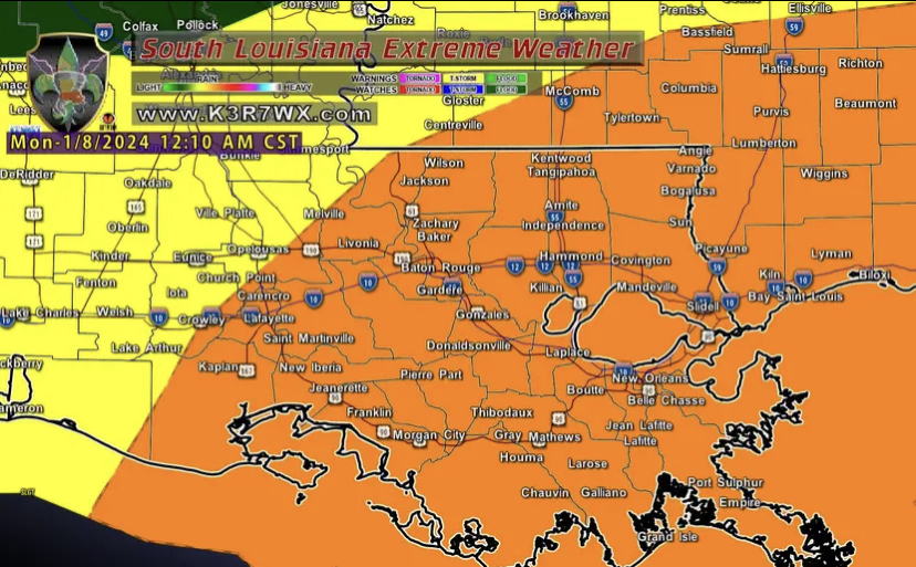
They moved the enhanced risk area farther west today. If you are in Lafayette, Crowley, New Iberia, Breaux Bridge, Opelousas, Livonia, and New Roads ….you will probably get a text or comm from your kids school soon on possible early dismissal or canceled athletic practice since this will likely start in late afternoon/early evening for you.


This post was edited on 1/8/24 at 6:48 am
Posted on 1/8/24 at 6:50 am to dewster
Whats the timeline for the most severe portion coming through the Lafayette area. It the threat more on the severe thunderstorm side with slight tornado risk? Or is the tornado risk ramping up .thx for the updates everyone
Posted on 1/8/24 at 6:51 am to trussthetruzz
quote:Which ones? Not attacking this person, just curious how many times it's happened.
These lessons were learned years ago with many of the floods that used to catch us off guard.
Posted on 1/8/24 at 7:00 am to FrankandBeans
quote:
Seeing some hints of winter weather event around 22nd. Any validity to that?
My local government has heard 22-24th might be extreme low temps in the models. They are planning on a team to handle broken pipes and other cold weather issues. Still too far out to know for sure.
This post was edited on 1/8/24 at 7:01 am
Posted on 1/8/24 at 7:03 am to Tigerfan19
quote:
Whats the timeline for the most severe portion coming through the Lafayette area. It the threat more on the severe thunderstorm side with slight tornado risk? Or is the tornado risk ramping up .thx for the updates everyone
Probably western part of Lafayette area mid-late afternoon.
They don’t usually throw around the severe weather enhanced risk tag. Keep an eye on their forecast throughout the day because it may change and it does look pretty serious. Probably best to be off the roads for this if you can.
This post was edited on 1/8/24 at 7:05 am
Posted on 1/8/24 at 7:06 am to Tarps99
quote:
Another option will be WDSU on air since they have their own radar site at their tower site in Chalmette. Unfortunately as much as they advertise it as the best thing since sliced bread since they are the only TV station that kept their own radar site, it looks like something from the early 2000’s with a really low resolution and small color palette. Not sure if it can be switched to storm velocity to see the winds.
I Remember when they first introduced Super Doppler 3000 or whatever it was called, it was a big deal that they constantly promoted.
Posted on 1/8/24 at 7:08 am to Tiger985
quote:
Schools close for everything these. Tornado warning? Into the hallway like the old days.
And then the Moore EF5 happened and multiple schools were hit. Students huddling in the halls were trapped, injured, and some were killed.
Oh and as the tornado approached, frantic parents were climbing the fence and trying to get through the carpool line to get their kids out of there. They got hit too.
This post was edited on 1/8/24 at 7:39 am
Posted on 1/8/24 at 7:36 am to member12
This is the kind of day where there may be 3 tornadoes within 40 miles but if one of them doesn’t plow through the middle of their kid’s school mouth breathers will be saying “I can’t believe they dismissed early just for this, meteorologists missed it again!!”
Posted on 1/8/24 at 7:38 am to MOT
quote:
This is the kind of day where there may be 3 tornadoes within 40 miles but if one of them doesn’t plow through the middle of their kid’s school mouth breathers will be saying “I can’t believe they dismissed early just for this, meteorologists missed it again!!”
Yeah. And for some folks in south Louisiana, this is going to get bad as some kids are getting onto school buses.
Posted on 1/8/24 at 7:39 am to member12
If an EF5 ever hit here, it wouldn’t matter where you were. There’s nowhere to hide from that.
Posted on 1/8/24 at 7:42 am to Tiger985
quote:
Combine that with social media and this is what you get. Overreaction.
And injury attorneys.
Posted on 1/8/24 at 8:10 am to LSUFanHouston
quote:
I Remember when they first introduced Super Doppler 3000 or whatever it was called, it was a big deal that they constantly promoted.
Much of the area in the enhanced risk zone is without doppler coverage right now. Slidell and Lake Charles are the nearest NWS dopplers. I think the Slidell one might be offline right now because it's moving to Hammond.
There has always been a huge gap between Lafayette and Baton Rouge. Neither city has decent coverage outside of the local news stations.
This post was edited on 1/8/24 at 8:11 am
Posted on 1/8/24 at 8:13 am to theunknownknight
quote:
If an EF5 ever hit here, it wouldn’t matter where you were. There’s nowhere to hide from that.
It wouldn't take an EF5, especially if kids are on school buses stuck in Baton Rouge traffic at the time. This is going to cross into the metro right at the early part of rush hour.
Prediction and forecasting has improved a lot over the years. They know the chances are there. No reason to put people at risk when they don't have to.
Popular
Back to top


 3
3


