- My Forums
- Tiger Rant
- LSU Recruiting
- SEC Rant
- Saints Talk
- Pelicans Talk
- More Sports Board
- Fantasy Sports
- Golf Board
- Soccer Board
- O-T Lounge
- Tech Board
- Home/Garden Board
- Outdoor Board
- Health/Fitness Board
- Movie/TV Board
- Book Board
- Music Board
- Political Talk
- Money Talk
- Fark Board
- Gaming Board
- Travel Board
- Food/Drink Board
- Ticket Exchange
- TD Help Board
Customize My Forums- View All Forums
- Show Left Links
- Topic Sort Options
- Trending Topics
- Recent Topics
- Active Topics
Started By
Message
re: Ian Observation Thread (Storm Track and Radar inside)
Posted on 9/28/22 at 7:51 am to GetCocky11
Posted on 9/28/22 at 7:51 am to GetCocky11
A relatively large slot of warmer cloud tops is starting to get wrapped into the core again. With so little time left until landfall, little signs of potential struggles for the inner core may not help much, but we'll take what we can get.

 1
1

Posted on 9/28/22 at 7:51 am to LanierSpots
quote:
I manufacture fishing tackle. Im not a store. I build and sell to stores like Dicks, etc. My shop basically has parts. It is in a much dangerous area than my house. I went there yesterday and did what I could to protect it from water but its two miles from the gulf. Its in a older building but its block and has storm windows and Im on the second floor. Im just praying it is not damaged
My wife's cousin lives in Cortez (on the water) and refused to leave. Based on your description of where your shop is, I imagine its very close. I hope for the best for both of you. I already lost cameras at our property on the bay side of LBK so I'm in the dark with regards to that but I fully expect a few feet of water. I guess thats better than yesterday morning when I expected 10+ and possible nothing left.
Posted on 9/28/22 at 7:52 am to GetCocky11
quote:
Jim Cantore being kind of annoying on TWC. Talks about how frustrating it is to see hurricane after hurricane approach or reach Cat5 status.
Why would this bother you? Do you root for Cat 5? It is frustrating that this continues to happen. Youre easily triggered.

Posted on 9/28/22 at 7:52 am to stout
Eye wall is only about 20 miles offshore from Cape Coral.

Posted on 9/28/22 at 7:52 am to NorthEndZone
quote:
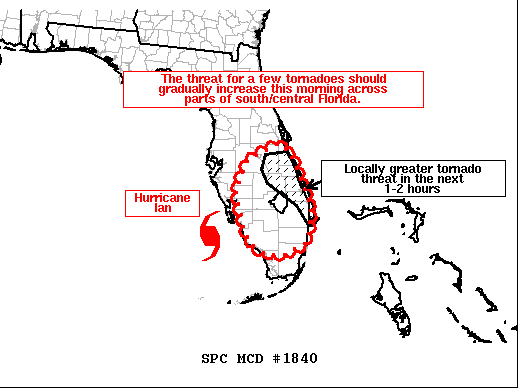
After a relative lull in activity overnight, it appears that an outer rain band associated with Hurricane Ian is becoming more organized along and just offshore the east coast of the southern and central Florida Peninsula. Multiple CG lightning flashes have recently been observed with low-topped cells within this band, indicative of robust updrafts. With filtered diurnal heating commencing, even a modest increase in surface temperatures should translate to greater instability developing across south/central FL since the low-level airmass remains very moist. A strongly sheared low-level environment is also present across much of this region, which is mostly in the northeastern quadrant of Ian's overall circulation. Recent VWPs from area radars show plentiful low-level shear, which will support updraft rotation with any low-topped supercell that can be sustained. A corresponding threat for a few tornadoes should exist with cells in these outer rain bands through the rest of the morning. A locally greater tornado threat in the short term should focus across parts of the east-central FL Peninsula where convection from an outer rain band will continue to move onshore. Low-level winds backed to a more east-southeasterly component along the east coast of FL should act to enhance effective SRH, and aid in updraft rotation.

Posted on 9/28/22 at 7:53 am to stout

938

Posted on 9/28/22 at 7:53 am to slackster
quote:
A relatively large slot of warmer cloud tops is starting to get wrapped into the core again. With so little time left until landfall, little signs of potential struggles for the inner core may not help much, but we'll take what we can get.
Looks like it's already beating that dry air off with both hands. Hot towers firing in the western eye wall again. A ton of lightning. Getting enough condensation and latent heating to moisten the core which you can see in the latest IR scans showing the center darkening again. The eye looks primed to clear soon.
This post was edited on 9/28/22 at 7:57 am
Posted on 9/28/22 at 7:54 am to nola tiger lsu
So my friends who stayed, on the water, in port Charlotte... going on 8 hours of silence now. I can only imagine the amount of regret they're currently experiencing.

Posted on 9/28/22 at 7:55 am to iron banks
quote:
Looks like Orlando might get more impacts than Tampa now with this current track.
the eye, but the NW and strongest part of the storm seems to be tracking right over them. they're NE of tampa and about 75 miles SW of orlando.
thx boat/rtravens

Posted on 9/28/22 at 7:55 am to stout
Got lucky over here. Wishing the best for anyone who has ended up in this thing’s path.
Posted on 9/28/22 at 7:56 am to TigerDude80
Ian is a bad mofo right now. My uncles family lives in Venice beach they are older yankee transplants and I hope they had the sense to leave. No word yet if they got out. Dingbat thought the hotel she works at was gonna be open actually had people checking in yesterday truly unbelievable
Posted on 9/28/22 at 7:56 am to The Boat

Posted on 9/28/22 at 7:57 am to TH03
quote:
yes, but this season is looking like an outlier.
Why is it when we have fewer storms it's an outlier vs when we have a 2020 type of season we get told that is normal? Record years are the outliers.
Years like this are way more common overall.
We had 6 straight years prior to this one of crazy storm activity so I guess people are conditioned to that and have short-term memories of how rare what has happened the past 6 years is.
2020 and 2021 were crazy but wasn't that fueled by a La Niña that had developed?
Posted on 9/28/22 at 7:57 am to The Boat
quote:
Looks like it's already beating that dry air off with both hands. Hot towers firing in the western eye wall again. A ton of lightning. Getting enough condensation and latent heating to moisten the core which you can see in the latest IR scans showing the center darkening again. The eye looks primed to clear soon.
lawdd. eye kinda looking like a butthole

This post was edited on 9/28/22 at 7:58 am

Posted on 9/28/22 at 7:58 am to Roll Tide Ravens
Yeah and he’s kinda refusing to go inland at the moment.
Posted on 9/28/22 at 7:59 am to paperwasp
You folks down there outside of landfall area pay attention to the Mesoscale discussion Paperwasp just posted. We're likely to see the tornado potential ramp back up. Keep some way to know if you're in a warning handy. Ian has been an above average tornado producer.
Posted on 9/28/22 at 7:59 am to GeorgeReymond
quote:
Video from Matt Tilman of Bayshore Blvd in Tampa. The bay being sucked out.
No matter how many times we see that with these storms, it's still wild as hell.
Posted on 9/28/22 at 7:59 am to TH03
quote:
lawdd. eye kinda looking like a butthole
It needs some Preparation H
Posted on 9/28/22 at 8:00 am to GeorgeReymond
quote:
Video from Matt Tilman of Bayshore Blvd in Tampa. The bay being sucked out.
Can you imagine living back in the day before they had advanced weather alerts? Imagine not having a clue that Ian was coming, seeing a bay looking like this, then getting walloped by a CAT 4/5 storm with no warning
No thanks
Posted on 9/28/22 at 8:00 am to LegendInMyMind
Where is SWA704 going? Do they not know about the bigass storm in their way?

 Page 299 of 465

Popular
Back to top