- My Forums
- Tiger Rant
- LSU Recruiting
- SEC Rant
- Saints Talk
- Pelicans Talk
- More Sports Board
- Fantasy Sports
- Golf Board
- Soccer Board
- O-T Lounge
- Tech Board
- Home/Garden Board
- Outdoor Board
- Health/Fitness Board
- Movie/TV Board
- Book Board
- Music Board
- Political Talk
- Money Talk
- Fark Board
- Gaming Board
- Travel Board
- Food/Drink Board
- Ticket Exchange
- TD Help Board
Customize My Forums- View All Forums
- Show Left Links
- Topic Sort Options
- Trending Topics
- Recent Topics
- Active Topics
Started By
Message

 0
0

Posted on 8/22/23 at 1:12 pm to PureBlood
It's probably going to erode in a few more weeks
Posted on 8/22/23 at 1:38 pm to LSURussian
quote:
A warm-core non-frontal synoptic-scale cyclone, originating over tropical or subtropical waters, with organized deep convection and a closed surface wind circulation about a well-defined center. A tropical cyclone in which the maximum sustained surface wind speed (using the U.S. 1-minute average) ranges from 34 kt (39 mph or 63 km/hr).
The only difference is now you have high resolution satellite imagery all over the globe and buoys that send data periodically.
Before then you had to rely on ship reports and aircraft traveling in the area to pin point storms.
So no telling how many more storms could have met the requirements of a tropical storm or hurricane that did not impact land or shipping before the dawn of the satellite era of weather forecasting.
That is why I will always look at a "record breaking number of storms year" with a grain of salt.
This post was edited on 8/22/23 at 2:58 pm
Posted on 8/22/23 at 1:47 pm to deuce985
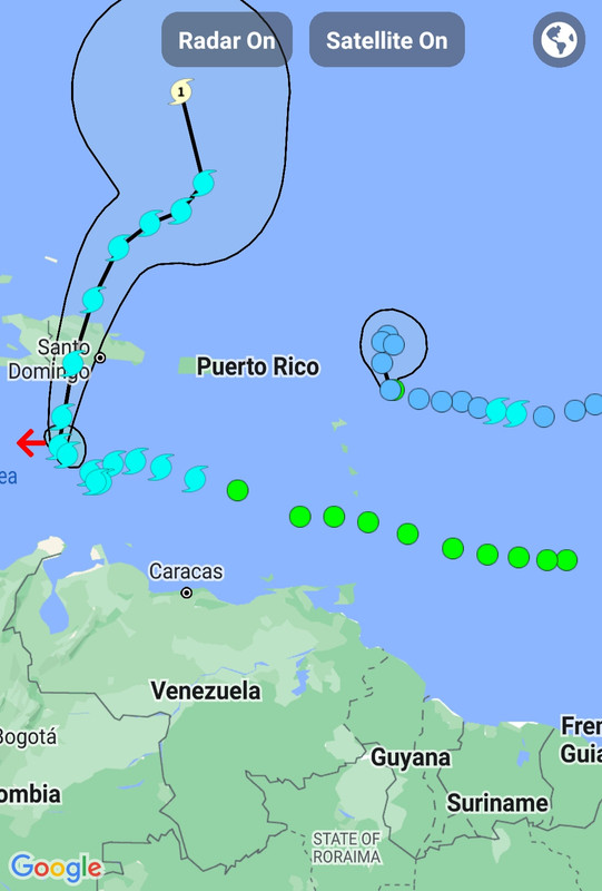
Franklin is either gonna have a new center reform in the convection or he is gonna be running well west of track.
Posted on 8/22/23 at 1:51 pm to Tarps99
quote:
That is why I will always look at "record breaking number of storms year" with a grain of salt.
Everyone should.
Posted on 8/22/23 at 1:58 pm to Tarps99
quote:
The only difference is now you have high resolution satellite imagery all over the globe and bouys that send data periodically.
Before then you had to rely on ship reports and aircraft traveling in the area to pin point storms.
So no telling how many more storms could have met the requirements of a tropical storm or hurricand that did not impact land or shipping before the dawn of the satellite era of weather forecasting.
That's why I always argue that we need to have an asterisk beside total storm numbers in the satellite era, and it needs to be stressed and accounted for when comparisons are made.
I doubt it is as drastic a difference, but I believe it would he quite evident, as total tornado counts post-NEXRAD. The jump in confirmed tornadoes was huge when NEXRAD was implemented, an even bigger jump than what we have seen since Dual-pol was implemented.
Posted on 8/22/23 at 2:00 pm to deltaland
quote:
I swear Franklin has been sitting in same spot for 3 days
Yeah I have been waiting for it to turn north. It hasn't.
Or maybe it has slightly but it hasn't moved much.
This post was edited on 8/22/23 at 2:02 pm
Posted on 8/22/23 at 2:15 pm to HottyToddy7
quote:
Yeah I have been waiting for it to turn north. It hasn't.
Or maybe it has slightly but it hasn't moved much.
It is just practically stalled right now. If you look at the center point locations you can see that the northern turn has already happened.
This post was edited on 8/22/23 at 2:16 pm
Posted on 8/22/23 at 8:58 pm to LegendInMyMind
3 major global models put a storm in the gulf around August 29-31. I’d take a weak hurricane at this point

Posted on 8/22/23 at 9:19 pm to purple18
quote:
3 major global models put a storm in the gulf around August 29-31.
It will be gone tomorrow
Posted on 8/22/23 at 9:22 pm to Tarps99
quote:
That is why I will always look at a "record breaking number of storms year" with a grain of salt.
ACE is your friend

Posted on 8/22/23 at 10:21 pm to rds dc
This shite so gay. Bring a real storm damnit, to Louisiana so i can watch it on Live Stream.
Posted on 8/22/23 at 10:25 pm to tketaco
quote:
This shite so gay. Bring a real storm damnit, to Louisiana so i can watch it on Live Stream.
Going for a downvote record, huh?
Posted on 8/22/23 at 10:26 pm to tketaco
I want rain also but be careful what you wish for.
Posted on 8/23/23 at 6:55 am to Cosmo
What is ACE again?
* I did a Google search and got the complicated definition.
* I did a Google search and got the complicated definition.
This post was edited on 8/23/23 at 6:58 am
Posted on 8/23/23 at 7:00 am to pwejr88
Accumulated Cyclone Energy.
Basically, the longer the winds are strong, the higher the ACE. A weak TS will produce next to nothing. A long track CV storm that remains a major for days will produce a lot.
Basically, the longer the winds are strong, the higher the ACE. A weak TS will produce next to nothing. A long track CV storm that remains a major for days will produce a lot.
Posted on 8/23/23 at 10:19 am to rds dc

:that’s a penis:
Posted on 8/23/23 at 10:31 am to deltaland
Posted on 8/23/23 at 12:19 pm to tketaco
quote:
This shite so gay. Bring a real storm damnit, to Louisiana so i can watch it on Live Stream.
Maybe a storm can take your house out, no one else’s… I’d watch that on live stream.
a-hole.
Posted on 8/23/23 at 12:27 pm to purple18
quote:
3 major global models put a storm in the gulf around August 29-31. I’d take a weak hurricane at this point
Did anyone really think we would not have a hurricane the first weekend of SEC football?

 Page 35 of 139

Popular
Back to top