- My Forums
- Tiger Rant
- LSU Recruiting
- SEC Rant
- Saints Talk
- Pelicans Talk
- More Sports Board
- Fantasy Sports
- Golf Board
- Soccer Board
- O-T Lounge
- Tech Board
- Home/Garden Board
- Outdoor Board
- Health/Fitness Board
- Movie/TV Board
- Book Board
- Music Board
- Political Talk
- Money Talk
- Fark Board
- Gaming Board
- Travel Board
- Food/Drink Board
- Ticket Exchange
- TD Help Board
Customize My Forums- View All Forums
- Show Left Links
- Topic Sort Options
- Trending Topics
- Recent Topics
- Active Topics
Started By
Message
re: Hurricane Nate - Moving Inland - Hurricane Season Over?
Posted on 10/6/17 at 8:53 pm to slackster

Posted on 10/6/17 at 8:53 pm to slackster
Tractor and 4 wheeler in among a shite load of pines at the hunting camp. It's in central Baldwin county AL
Probably going to move them out in the open tomorrow
Luckily the river house we have on Magnolia river is well over 100 yards from the water.
Probably going to move them out in the open tomorrow
Luckily the river house we have on Magnolia river is well over 100 yards from the water.
This post was edited on 10/6/17 at 8:57 pm
 1
1


Posted on 10/6/17 at 8:54 pm to Duke
quote:
Duke
Thank you.
Posted on 10/6/17 at 8:56 pm to Impotent Waffle
Any expected shift with the next advisory?
Posted on 10/6/17 at 8:58 pm to slackster
I'm confused about the surge "above ground level". I've heard that a lot this year in storm forcasts; but I always thought storm surges were benchmarked above sea level.
My garage is 5', and the house is 13.5' above sea level. Trying to predict how bad the lower level will flood. I'm positive the actual living area is ok.
My garage is 5', and the house is 13.5' above sea level. Trying to predict how bad the lower level will flood. I'm positive the actual living area is ok.
Posted on 10/6/17 at 9:01 pm to Bama and Beer
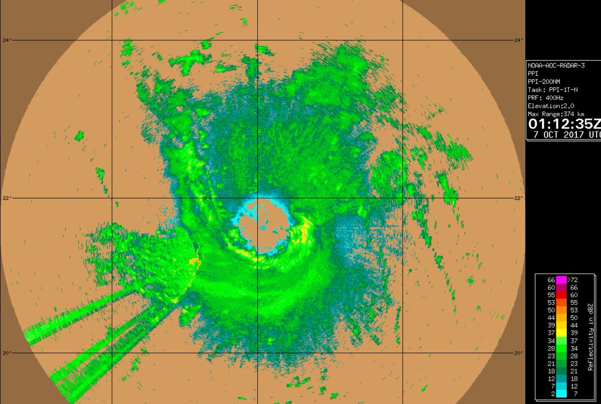
Nerd board met posted inner core looks like its organizing and becoming vertically stacked via P-3 radar. Deep convection is increasing upshear.
This post was edited on 10/6/17 at 9:02 pm
Posted on 10/6/17 at 9:01 pm to rds dc
Official NWS rainfall forecast:

Posted on 10/6/17 at 9:02 pm to Dizz
If it was expected, wouldn’t it already just be the track?
Posted on 10/6/17 at 9:03 pm to TigerStripes06
No NHC only changes the official track for certain advisories.
Posted on 10/6/17 at 9:03 pm to jlc05
quote:
via P-3 radar
Always very cool to see
Posted on 10/6/17 at 9:05 pm to Impotent Waffle
Start getting gusts Sat night?
Posted on 10/6/17 at 9:06 pm to Dizz
quote:
Any expected shift with the next advisory?
Yea, north
This post was edited on 10/6/17 at 9:07 pm

Posted on 10/6/17 at 9:06 pm to Mr. Hangover
Posted on 10/6/17 at 9:07 pm to slackster
quote:
Notice the wind barbs north of the center. They're due north of the storm yet they're still out of the SE when they should be out of the E only. There is convection all around Nate, but not all of it is part of Nate, if that makes sense.
Good point. The current circulation is elongated out into the background flow, in part, b/c of that wave that moved out across the Gulf ahead of Nate.

Posted on 10/6/17 at 9:07 pm to Mr. Hangover
Thanks for the solid info.
Posted on 10/6/17 at 9:07 pm to Mr. Hangover

Posted on 10/6/17 at 9:09 pm to notiger1997
Bob Breck is talking about this thing getting up to a 2 or 3
Posted on 10/6/17 at 9:11 pm to Duke
quote:
Rumblings about a center relocation among the nerd message boards. Resettling under the big convection SE might open the door for a little additional strengthening tonight.
Always, someone calling for a center relocation... Nate is mature enough of a system to prevent that from happening. Now, it wouldn't be surprising if Nate gives the appearance of slowing down at some point as the intense convection on the southern side rotates around.
Posted on 10/6/17 at 9:11 pm to Placebeaux
Breck has had a terrible track record recently.
Posted on 10/6/17 at 9:12 pm to dat yat
quote:
I'm confused about the surge "above ground level". I've heard that a lot this year in storm forcasts; but I always thought storm surges were benchmarked above sea level.
My garage is 5', and the house is 13.5' above sea level. Trying to predict how bad the lower level will flood. I'm positive the actual living area is ok.
So most of the surge products are measured in "inundation level" which means water above the ground, not above sea level.
This product will do both.
Choose your area on the map, choose the 10% exceedance height, then choose either "above datum" for above sea level, or "above ground" for above ground. You can mess around with the exceedance heights or choose a surge height and look at the probabilities instead.
If you need help with it, let me know.

 Page 108 of 193

Popular
Back to top