- My Forums
- Tiger Rant
- LSU Recruiting
- SEC Rant
- Saints Talk
- Pelicans Talk
- More Sports Board
- Fantasy Sports
- Golf Board
- Soccer Board
- O-T Lounge
- Tech Board
- Home/Garden Board
- Outdoor Board
- Health/Fitness Board
- Movie/TV Board
- Book Board
- Music Board
- Political Talk
- Money Talk
- Fark Board
- Gaming Board
- Travel Board
- Food/Drink Board
- Ticket Exchange
- TD Help Board
Customize My Forums- View All Forums
- Show Left Links
- Topic Sort Options
- Trending Topics
- Recent Topics
- Active Topics
Started By
Message
 0
0

Posted on 10/6/17 at 9:33 pm to elprez00
quote:
I moved to Nola in 94. Shortly after I moved here, I remember one storm less than 12 hrs from landfall in the panhandle and ol Bob was still on the news saying it still had a chance to basically take a 90 into the city. I asked around and people told me that was his MO.
I think that was Opal.
Posted on 10/6/17 at 9:33 pm to rds dc
Continued signs that Nate is getting better organized with formation of an eyewall and a principal rainband?

Posted on 10/6/17 at 9:35 pm to TigerstuckinMS
Posted on 10/6/17 at 9:36 pm to rds dc

Black dot sitting in the deep white convection. That's not a color you see very often. Super cold cloudtops popping off.
Posted on 10/6/17 at 9:37 pm to Duke
quote:
Black dot sitting in the deep white convection. That's not a color you see very often. Super cold cloudtops popping off.
What does that indicate?
Posted on 10/6/17 at 9:38 pm to Duke
quote:
Black dot sitting in the deep white convection. That's not a color you see very often. Super cold cloudtops popping off.
Nate is going off! Hopefully, fast movement and lack of a closed eyewall (for now) keeps RI off the table.
Posted on 10/6/17 at 9:39 pm to Duke
quote:
Black dot sitting in the deep white convection. That's not a color you see very often. Super cold cloudtops popping off.
That's pretty cool, in a not really good for us kind of way.
Posted on 10/6/17 at 9:39 pm to Duke
quote:
Black dot sitting in the deep white convection. That's not a color you see very often. Super cold cloudtops popping off.
That good or bad? As someone from Lafourche parish, do I upvote or downvote?
Posted on 10/6/17 at 9:40 pm to Bestbank Tiger
quote:
What does that indicate?
Super cold cloud tops, meaning storms that have shot way up into the atmosphere. Can be associated with strengthening, but it's not really a great barometer one way or the other.
Posted on 10/6/17 at 9:40 pm to maisweh
quote:
That good or bad? As someone from Lafourche parish, do I upvote or downvote?
You'd rather not see it, but it's not bad news by itself, if that makes sense.

Posted on 10/6/17 at 9:40 pm to maisweh
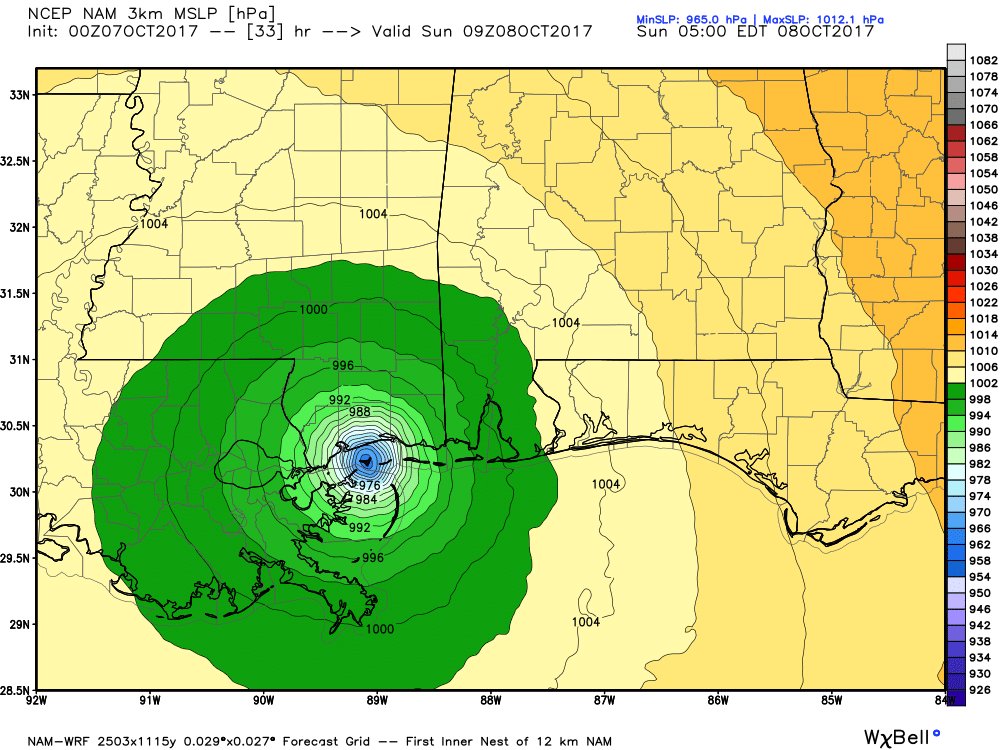
James Spann tweeted this. Must be accurate.
Posted on 10/6/17 at 9:42 pm to East Coast Band
It's not like he made the model  and it's the NAM

Posted on 10/6/17 at 9:43 pm to Bestbank Tiger
@WxMartha
The mayor of Thibodaux has declared a curfew from 10 PM Saturday through 7 AM Sunday #Nate
The mayor of Thibodaux has declared a curfew from 10 PM Saturday through 7 AM Sunday #Nate
Posted on 10/6/17 at 9:44 pm to East Coast Band
Surface temps in the northern Gulf are only around 83 right now. Is that going to work in our favor? It's high enough to feed the system but I remember from the past that you need it to be 85-90 for it to be hurricane steroids.

Posted on 10/6/17 at 9:45 pm to East Coast Band
quote:
James Spann tweeted this. Must be accurate.
The NAM and HRRR don't do well with storm strength itself, but each have had their moments with convection in tropical systems, and they're useful for looking at total rainfall estimates and whatnot. The HRRR had some pretty impressive runs during Harvey, for example.
Posted on 10/6/17 at 9:46 pm to rds dc
What year is it?
Posted on 10/6/17 at 9:47 pm to Bestbank Tiger
quote:
Surface temps in the northern Gulf are only around 83 right now. Is that going to work in our favor? It's high enough to feed the system but I remember from the past that you need it to be 85-90 for it to be hurricane steroids.
You need warm water AND deep water. The run up to the coast won't really have either, but the storm will also be hauling arse, so it won't matter a ton.
Posted on 10/6/17 at 9:47 pm to MrSmith
quote:
What year is it?
1993, I think. Based on the results LSU is producing on the football field.

 Page 110 of 193

Popular
Back to top