




 1
1






- My Forums
- Tiger Rant
- LSU Recruiting
- SEC Rant
- Saints Talk
- Pelicans Talk
- More Sports Board
- Fantasy Sports
- Golf Board
- Soccer Board
- O-T Lounge
- Tech Board
- Home/Garden Board
- Outdoor Board
- Health/Fitness Board
- Movie/TV Board
- Book Board
- Music Board
- Political Talk
- Money Talk
- Fark Board
- Gaming Board
- Travel Board
- Food/Drink Board
- Ticket Exchange
- TD Help Board
Customize My Forums- View All Forums
- Show Left Links
- Topic Sort Options
- Trending Topics
- Recent Topics
- Active Topics
Started By
Message
Posted on 10/7/26 at 10:10 pm to Roll Tide Ravens
With warnings up now we will get Intermediate Advisories every three hours. Those advisories won't include an updated track, though.
Posted on 10/7/26 at 10:12 pm to notiger1997
quote:
Can we just call them mini levees with walls in them and move on?
frick no, the Army Corps of Engineers is the reason the canals failed and flooded New Orleans. The Lakefront levees did not fail. I know they deal with both, but the levees did not fail in Nola.
there too many people love to say the "levees" failed
Posted on 10/7/26 at 10:19 pm to Chad504boy
quote:
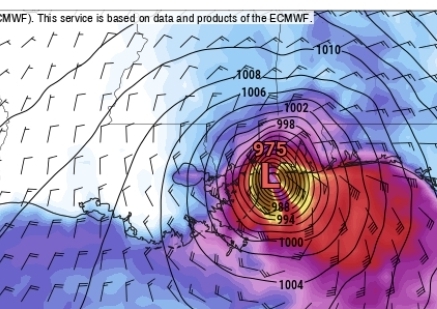
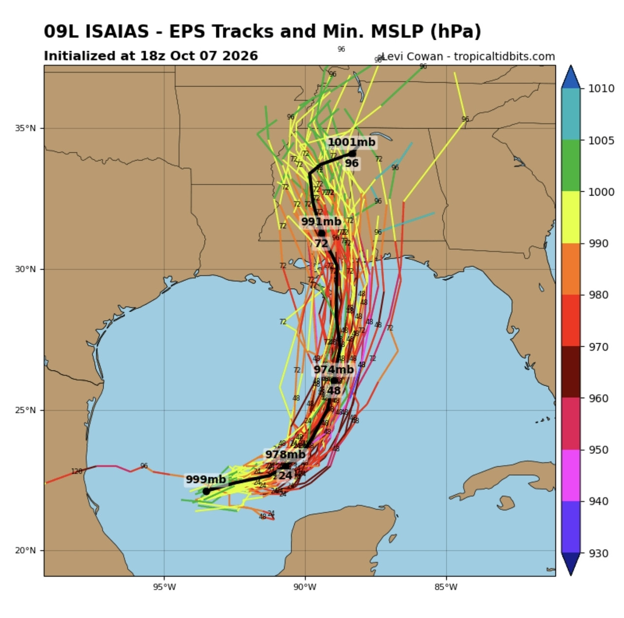
Is euro still trying to jam this into Houma?
Here's the latest operational and ensemble run
Posted on 10/7/26 at 10:25 pm to NorthEndZone
Dropsonde just after 10 PM update measured 982 mb. 6 mb drop in less than 3 hours.
Posted on 10/7/26 at 10:26 pm to t00f
Friend,
It is my understanding, which was influenced by a family friend with inside information on the history of our levees, that the Army Corps of Engineers did not want to build the I-wall levees, but were persuaded to do so by the local levee boards who insisted on that style so that homes would not have be removed along the outfall canals. Ultimately, the Army Corps of Engineers made the final decision, but they did so hoping to appease locals by putting the power of decision making in local hands.
I must applaud Mother on her prediction on this storm. Even this weekend she was comparing it Opal and said to me, “This storm is too similar to the ‘95 Opal. I think it will come ashore just west of Navarre and destroy all those beautiful sand dunes that slowly were coming back after Opal.”
Mother and I are headed out tomorrow to the house she built in Baldwin County. Uncle’s condo at Portofino should be fine and I will keep you informed as I am. It is quite a relief it should avoid the city, as I was initially quite concerned for the Berger house and all their skeletons. Talk about deathly projectiles.
Yours,
TulaneLSU
It is my understanding, which was influenced by a family friend with inside information on the history of our levees, that the Army Corps of Engineers did not want to build the I-wall levees, but were persuaded to do so by the local levee boards who insisted on that style so that homes would not have be removed along the outfall canals. Ultimately, the Army Corps of Engineers made the final decision, but they did so hoping to appease locals by putting the power of decision making in local hands.
I must applaud Mother on her prediction on this storm. Even this weekend she was comparing it Opal and said to me, “This storm is too similar to the ‘95 Opal. I think it will come ashore just west of Navarre and destroy all those beautiful sand dunes that slowly were coming back after Opal.”
Mother and I are headed out tomorrow to the house she built in Baldwin County. Uncle’s condo at Portofino should be fine and I will keep you informed as I am. It is quite a relief it should avoid the city, as I was initially quite concerned for the Berger house and all their skeletons. Talk about deathly projectiles.
Yours,
TulaneLSU
This post was edited on 10/7/26 at 10:32 pm
Posted on 10/7/26 at 10:28 pm to t00f
quote:
frick no, the Army Corps of Engineers is the reason the canals failed and flooded New Orleans.
There are levees along the canals, bruh
Posted on 10/7/26 at 10:32 pm to FutureMikeVIII
We have a hurricane.
Posted on 10/7/26 at 10:33 pm to t00f
quote:Id suggest it was the Cat 5 storm surge despite it dropping to a Cat 3 at landfall.
frick no, the Army Corps of Engineers is the reason the canals failed and flooded New Orleans.
Posted on 10/7/26 at 10:37 pm to Jake88
Posted on 10/7/26 at 10:39 pm to LSU=Champions
quote:
We have a hurricane.
OysterPB:

Posted on 10/7/26 at 10:39 pm to LSU=Champions
OtsterPoBoy - get your chapstick ready, bitch!
Posted on 10/7/26 at 10:40 pm to TDsngumbo
DoW about to have an expensive bill to pay
Posted on 10/7/26 at 10:40 pm to Jake88
Friend,
The storm surge on the Southshore of Orleans west of the Industrial Canal and Jefferson Parish ranged from 9-12 feet. The design of the I-wall levees along the outfall canals led to the failure of those levees. Water did not overtop the I-wall levees along the 17th Canal and London Canals. Catastrophic failure of those poorly designed levees is what led to the flooding of much of Orleans Parish west of the Industrial Canal and Old Metairie. Had the engineering, construction and maintenance of those I-wall levees held up to what they were designed to do, none of Orleans west of the Industrial Canal would have flooded.
The well designed levees along the shoreline of Lake Pontchartrain from New Orleans East to Kenner held up fine. The levees along the MRGO in St Bernard and New Orleans East were overtopped. And the I wall levee in the Lower 9th Ward probably would have failed had the barge not knocked it down.
Yours,
TulaneLSU
The storm surge on the Southshore of Orleans west of the Industrial Canal and Jefferson Parish ranged from 9-12 feet. The design of the I-wall levees along the outfall canals led to the failure of those levees. Water did not overtop the I-wall levees along the 17th Canal and London Canals. Catastrophic failure of those poorly designed levees is what led to the flooding of much of Orleans Parish west of the Industrial Canal and Old Metairie. Had the engineering, construction and maintenance of those I-wall levees held up to what they were designed to do, none of Orleans west of the Industrial Canal would have flooded.
The well designed levees along the shoreline of Lake Pontchartrain from New Orleans East to Kenner held up fine. The levees along the MRGO in St Bernard and New Orleans East were overtopped. And the I wall levee in the Lower 9th Ward probably would have failed had the barge not knocked it down.
Yours,
TulaneLSU
This post was edited on 10/7/26 at 10:44 pm
Posted on 10/7/26 at 10:42 pm to LSU=Champions
quote:
000
WTNT64 KNHC 080328
TCUAT4
Hurricane Isaias Tropical Cyclone Update
NWS National Hurricane Center Miami FL AL092026
1030 PM CDT Wed Oct 07 2026
...ISAIAS BECOMES A HURRICANE...
Dropsonde data from an Air Force Reserve hurricane hunter aircraft
indicates that Isaias has become a hurricane, with maximum sustained
winds of 75 mph (120 km/h) with higher gusts. The minimum central
pressure measured from another dropsonde launched in the eye was
982 mb (29.00 inches).
SUMMARY OF 1030 PM CDT...0330 UTC...INFORMATION
---------------------------------------------------
LOCATION...22.9N 91.9W
ABOUT 180 MI...290 KM NW OF PROGRESO MEXICO
ABOUT 460 MI...745 KM SSW OF THE MOUTH OF THE MISSISSIPPI RIVER
MAXIMUM SUSTAINED WINDS...75 MPH...120 KM/H
PRESENT MOVEMENT...ENE OR 70 DEGREES AT 9 MPH...15 KM/H
MINIMUM CENTRAL PRESSURE...982 MB...29.00 INCHES
$$
Forecaster Papin/Roberts
Posted on 10/7/26 at 10:45 pm to NorthEndZone
00z ICON still has this hitting around gulf breeze at 988 MB.
GFS is running.
GFS is running.
Posted on 10/7/26 at 10:48 pm to Hateradedrink
quote:
000 WTNT64 KNHC 080328 TCUAT4 Hurricane Isaias Tropical Cyclone Update NWS National Hurricane Center Miami FL AL092026 1030 PM CDT Wed Oct 07 2026 …ISAIAS BECOMES A HURRICANE… …
OYSTERPOBOY’S PREVIOUSLY STATED COMMITMENTS NOW IN EFFECT…
Dropsonde data from an Air Force Reserve hurricane hunter aircraft indicates that Isaias has become a hurricane, with maximum sustained winds of 75 mph (120 km/h) with higher gusts. The minimum central pressure measured from another dropsonde launched in the eye was 982 mb (29.00 inches).
With Isaias officially reaching hurricane intensity, conditions have now satisfied the previously established criteria for OysterPoBoy’s Tropical Obligations Agreement with the TigerDroppings OT Lounge.
While the National Hurricane Center does not issue advisories regarding individual contractual obligations, forecasters note that OysterPoBoy’s window for claiming this was merely a tropical storm has officially closed.
A significant increase in oral commitments is expected across the OT region, with multiple baws already reporting favorable conditions for landfall. Residents are reminded that all previously issued watches have now been upgraded to warnings, and OysterPoBoy should prepare for prolonged periods of servicing the affected population.
SUMMARY OF 1030 PM CDT…0330 UTC…INFORMATION LOCATION…22.9N 91.9W ABOUT 180 MI…290 KM NW OF PROGRESO MEXICO ABOUT 460 MI…745 KM SSW OF THE MOUTH OF THE MISSISSIPPI RIVER MAXIMUM SUSTAINED WINDS…75 MPH…120 KM/H PRESENT MOVEMENT…ENE OR 70 DEGREES AT 9 MPH…15 KM/H MINIMUM CENTRAL PRESSURE…982 MB…29.00 INCHES
OYSTERPOBOY OBLIGATION STATUS…NOW IN EFFECT
EXPECTED DURATION…UNTIL ALL OT BAWS ARE SATISFIED
PROBABILITY OF BACKTRACKING…0 PERCENT
$$ Forecaster Papin/Roberts Special Coordination: TigerDroppings OT Lounge
This post was edited on 10/7/26 at 10:52 pm
Posted on 10/7/26 at 10:52 pm to TulaneLSU
Thanks! You are correct.
Posted on 10/7/26 at 10:53 pm to TDsngumbo
quote:
000 WTNT64 KNHC 080328 TCUAT4 Hurricane Isaias Tropical Cyclone Update NWS National Hurricane Center Miami FL AL092026 1030 PM CDT Wed Oct 07 2026 …ISAIAS BECOMES A HURRICANE… …
OYSTERPOBOY’S PREVIOUSLY STATED COMMITMENTS NOW IN EFFECT…
Dropsonde data from an Air Force Reserve hurricane hunter aircraft indicates that Isaias has become a hurricane, with maximum sustained winds of 75 mph (120 km/h) with higher gusts. The minimum central pressure measured from another dropsonde launched in the eye was 982 mb (29.00 inches).
With Isaias officially reaching hurricane intensity, conditions have now satisfied the previously established criteria for OysterPoBoy’s Tropical Obligations Agreement with the TigerDroppings OT Lounge.
While the National Hurricane Center does not issue advisories regarding individual contractual obligations, forecasters note that OysterPoBoy’s window for claiming this was merely a tropical storm has officially closed.
A significant increase in oral commitments is expected across the OT region, with multiple baws already reporting favorable conditions for landfall. Residents are reminded that all previously issued watches have now been upgraded to warnings, and OysterPoBoy should prepare for prolonged periods of servicing the affected population.
SUMMARY OF 1030 PM CDT…0330 UTC…INFORMATION LOCATION…22.9N 91.9W ABOUT 180 MI…290 KM NW OF PROGRESO MEXICO ABOUT 460 MI…745 KM SSW OF THE MOUTH OF THE MISSISSIPPI RIVER MAXIMUM SUSTAINED WINDS…75 MPH…120 KM/H PRESENT MOVEMENT…ENE OR 70 DEGREES AT 9 MPH…15 KM/H MINIMUM CENTRAL PRESSURE…982 MB…29.00 INCHES
OYSTERPOBOY OBLIGATION STATUS…NOW IN EFFECT
EXPECTED DURATION…UNTIL ALL OT BAWS ARE SATISFIED
PROBABILITY OF BACKTRACKING…0 PERCENT
$$ Forecaster Papin/Roberts Special Coordination: TigerDroppings OT Lounge
I heard he's starting preparing:

Posted on 10/7/26 at 10:54 pm to TDsngumbo
When is the blowjob going to happen?

 Page 82 of 107



Popular

Back to top
 Follow TigerDroppings for LSU Football News