- My Forums
- Tiger Rant
- LSU Recruiting
- SEC Rant
- Saints Talk
- Pelicans Talk
- More Sports Board
- Fantasy Sports
- Golf Board
- Soccer Board
- O-T Lounge
- Tech Board
- Home/Garden Board
- Outdoor Board
- Health/Fitness Board
- Movie/TV Board
- Book Board
- Music Board
- Political Talk
- Money Talk
- Fark Board
- Gaming Board
- Travel Board
- Food/Drink Board
- Ticket Exchange
- TD Help Board
Customize My Forums- View All Forums
- Show Left Links
- Topic Sort Options
- Trending Topics
- Recent Topics
- Active Topics
Started By
Message
re: Helene - Recovery Begins...Devastating Flash Flooding in Western NC and Eastern TN
Posted on 9/23/24 at 9:18 pm to RummelTiger
Posted on 9/23/24 at 9:18 pm to RummelTiger
in Texas Heat? you Maniac!
 0
0

Posted on 9/23/24 at 9:19 pm to Duke
Thank you. Appreciate this information.

Posted on 9/23/24 at 9:19 pm to t00f
Posted on 9/23/24 at 9:49 pm to Lord of Bees
quote:
Thank you. Appreciate this information.
Tampa Shield [Engage] OFF
Posted on 9/23/24 at 9:51 pm to ColoradoTiger1987
I mean big bend forest is what 99.99% of everyone should be rooting for
Posted on 9/23/24 at 9:51 pm to Mr Roboto
Not sure where you’re at but in Pensacola gas stations were a heavy flow of traffic this morning and every Facebook group I’m in is talking about it.
Lots of transplants freaking out because they’ve never been through a storm.
Lots of transplants freaking out because they’ve never been through a storm.

Posted on 9/23/24 at 9:56 pm to Bobby OG Johnson
Posted on 9/23/24 at 10:00 pm to Bobby OG Johnson
What are the chances Atlanta area gets tropical storm winds?
That could be a fun time.
That could be a fun time.
Posted on 9/23/24 at 10:06 pm to Purple Spoon
Very strong. I wonder if they get some cat 1 winds if this can make strong 4 at landfall
Posted on 9/23/24 at 10:06 pm to Purple Spoon

Posted on 9/23/24 at 10:07 pm to Chad504boy
quote:
big bend forest is what 99.99% of everyone should be rooting for
.01% checking in
I lived in a trailer house once for over 2 months. Those people are my people. I'm hoping for an eastern turn toward tampa. A west turn toward panama would break the soul of that area.
Posted on 9/23/24 at 10:08 pm to Purple Spoon
quote:
What are the chances Atlanta area gets tropical storm winds?
Pretty good. It'll be moving at a good clip and starting to interact with the trough/associated low.
Posted on 9/23/24 at 10:09 pm to Turnblad85
That’s what sucks about this. What is good for some folks is devastating for others. Really wish this thing could just die out for the good of everyone.
This post was edited on 9/23/24 at 10:13 pm

Posted on 9/23/24 at 10:12 pm to rds dc
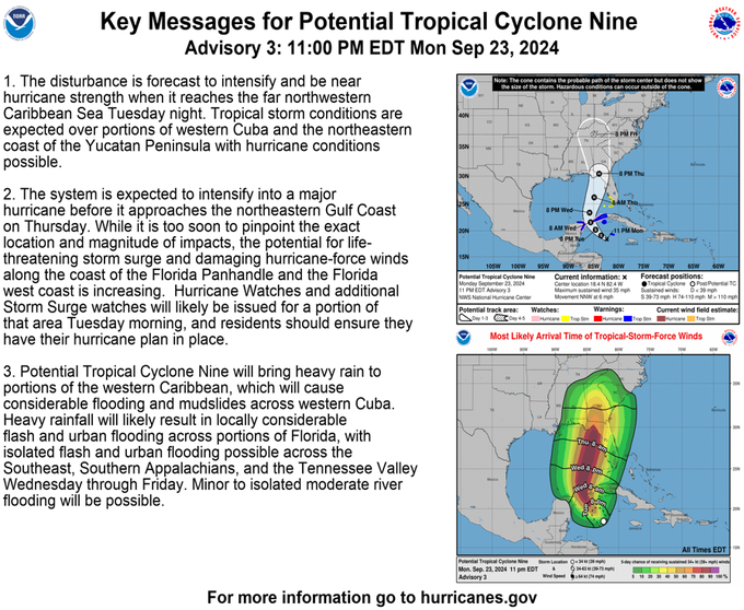
10 PM CDT advisory.

Potential Tropical Cyclone Nine Advisory Number 3
NWS National Hurricane Center Miami FL AL092024
1100 PM EDT Mon Sep 23 2024
...STORM SURGE AND TROPICAL STORM WATCHES ISSUED FOR A PORTION OF
SOUTHWEST FLORIDA...
SUMMARY OF 1100 PM EDT...0300 UTC...INFORMATION
-----------------------------------------------
LOCATION...18.4N 82.4W
ABOUT 100 MI...160 KM SW OF GRAND CAYMAN
ABOUT 290 MI...470 KM SE OF THE WESTERN TIP OF CUBA
MAXIMUM SUSTAINED WINDS...35 MPH...55 KM/H
PRESENT MOVEMENT...NNW OR 330 DEGREES AT 6 MPH...9 KM/H
MINIMUM CENTRAL PRESSURE...1002 MB...29.59 INCHES
FORECAST POSITIONS AND MAX WINDS
INIT 24/0300Z 18.4N 82.4W 30 KT 35 MPH...POTENTIAL TROP CYCLONE
12H 24/1200Z 19.1N 83.5W 35 KT 40 MPH...TROPICAL CYCLONE
24H 25/0000Z 20.2N 84.6W 45 KT 50 MPH
36H 25/1200Z 21.6N 85.6W 60 KT 70 MPH
48H 26/0000Z 23.4N 85.8W 75 KT 85 MPH
60H 26/1200Z 26.2N 84.9W 90 KT 105 MPH
72H 27/0000Z 30.4N 83.9W 95 KT 110 MPH...INLAND
96H 28/0000Z 37.0N 85.0W 15 KT 15 MPH...POST-TROPICAL
120H 29/0000Z...DISSIPATED
It should be noted that the 72-hour forecast allows for a little weakening after moving inland, so the cyclone is still expected to be at major hurricane
strength at landfall.
From NHC’s discussion:
It should also be noted that the cyclone is expected to grow in
size while it traverses the Gulf. Thus, the storm surge, wind, and
rainfall impacts will extend well away from the center, particularly
to the east of the system. In addition, the fast forward speed
while it crosses the coast will likely result in farther inland
penetration of strong winds over parts of the southeastern United
States after landfall.
This post was edited on 9/23/24 at 10:16 pm
Posted on 9/23/24 at 10:13 pm to Bobby OG Johnson
Still forecasted to make landfall as a major just prior to the 72-hour position below.
quote:
Potential Tropical Cyclone Nine Discussion Number 3
NWS National Hurricane Center Miami FL AL092024
1100 PM EDT Mon Sep 23 2024
An upper-level low over the northeastern Yucatan Peninsula has been
imparting some southwesterly vertical wind shear over the
disturbance. This has probably caused a temporary disruption in
development. Dynamical guidance shows this low weakening with time,
resulting in a reduction of shear in an environment that is
otherwise very conducive for intensification. The system is
projected to move over waters of very high ocean heat content,
which should lead to considerable strengthening during the forecast
period. The official intensity forecast is similar to the previous
one and lies between the statistical-dynamical model guidance and
the purely dynamical model predictions. It should be noted that
the 72-hour forecast allows for a little weakening after moving
inland, so the cyclone is still expected to be at major hurricane
strength at landfall.
It should also be noted that the cyclone is expected to grow in
size while it traverses the Gulf. Thus, the storm surge, wind, and
rainfall impacts will extend well away from the center, particularly
to the east of the system. In addition, the fast forward speed
while it crosses the coast will likely result in farther inland
penetration of strong winds over parts of the southeastern United
States after landfall.
FORECAST POSITIONS AND MAX WINDS
INIT 24/0300Z 18.4N 82.4W 30 KT 35 MPH...POTENTIAL TROP CYCLONE
12H 24/1200Z 19.1N 83.5W 35 KT 40 MPH...TROPICAL CYCLONE
24H 25/0000Z 20.2N 84.6W 45 KT 50 MPH
36H 25/1200Z 21.6N 85.6W 60 KT 70 MPH
48H 26/0000Z 23.4N 85.8W 75 KT 85 MPH
60H 26/1200Z 26.2N 84.9W 90 KT 105 MPH
72H 27/0000Z 30.4N 83.9W 95 KT 110 MPH...INLAND
96H 28/0000Z 37.0N 85.0W 15 KT 15 MPH...POST-TROPICAL
120H 29/0000Z...DISSIPATED
$$
Forecaster Pasch
Posted on 9/23/24 at 10:14 pm to NorthEndZone
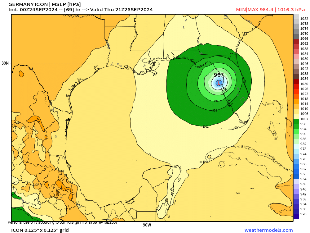
0z ICON takes dead aim on Tampa
This post was edited on 9/23/24 at 10:20 pm
Posted on 9/23/24 at 10:14 pm to Roll Tide Ravens
quote:
Interestingly, NHC no longer has it reaching major hurricane status
Always read the discussion.
quote:
It should be noted that the 72-hour forecast allows for a little weakening after moving inland, so the cyclone is still expected to be at major hurricane strength at landfall.
Posted on 9/23/24 at 10:16 pm to Duke
quote:
Always read the discussion.
Yeah, caught that right after I made my post.
Posted on 9/23/24 at 10:18 pm to Roll Tide Ravens
I went to take a peek bc I saw 110 mph and inland.
Had to assume it was a major at landfall for that to be the forecast.
Had to assume it was a major at landfall for that to be the forecast.
This post was edited on 9/23/24 at 10:21 pm
Posted on 9/23/24 at 10:20 pm to Duke
Yeah, it didn’t make any sense to me that they weren’t thinking major still. Went back to read the full discussion and realized my error.

 Page 70 of 310

Popular
Back to top