- My Forums
- Tiger Rant
- LSU Recruiting
- SEC Rant
- Saints Talk
- Pelicans Talk
- More Sports Board
- Fantasy Sports
- Golf Board
- Soccer Board
- O-T Lounge
- Tech Board
- Home/Garden Board
- Outdoor Board
- Health/Fitness Board
- Movie/TV Board
- Book Board
- Music Board
- Political Talk
- Money Talk
- Fark Board
- Gaming Board
- Travel Board
- Food/Drink Board
- Ticket Exchange
- TD Help Board
Customize My Forums- View All Forums
- Show Left Links
- Topic Sort Options
- Trending Topics
- Recent Topics
- Active Topics
Started By
Message
re: Helene - Recovery Begins...Devastating Flash Flooding in Western NC and Eastern TN
Posted on 9/26/24 at 3:57 pm to Funky Tide 8
Posted on 9/26/24 at 3:57 pm to Funky Tide 8
Thanks for the link, best footage with context I’ve seen today. Btw, the surge is currently topping the road deck. 5-0 was bailing, as they should.
 1
1


Posted on 9/26/24 at 3:58 pm to GumboPot
quote:
Look at this one in the northern Atlantic headed to Europe.
Is it lost?

Posted on 9/26/24 at 3:58 pm to Boomdaddy65201
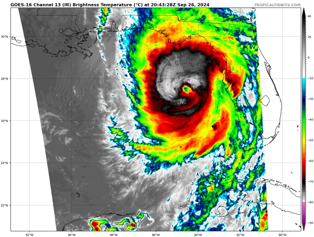
110 kts 125 mph per NHC at 5 pm
Posted on 9/26/24 at 3:59 pm to Oates Mustache
quote:
Eastern Tennessee is definitely going to have severe flooding an road issues. Going to be lots of washed out areas.
It won't be just east TN. We had a five inch rainfall one July day, and the bridges were swept away if overwash didn't undermine them.
The bridges over creeks were designed for average flow and the occasional heavy storm. Water stops flowing through culverts when the culvert is 2/3 full it loses its laminar flow. Most bridges are over culverts.
So far in the past three days we've had almost five inches of rain. The big rain hasn't happened yet, Rain doesn't soak into rocky mountains : it drains down hill.
TDOT has a good map that in past floods has been actively updated with closings, and the WLOS Asheville site has links to the North Carolina DoT website.
I wish the water level in Cherokee Lake had been a lot lower when we drove by it yesterday.

Posted on 9/26/24 at 3:59 pm to CajunLife
How far are you from the coast?
Posted on 9/26/24 at 4:00 pm to CajunLife
quote:
Damn.....were right in the middle of the path here in South Georgia.
Youre in for a rough night, friend.
Stay safe.
Posted on 9/26/24 at 4:00 pm to BigBro
Think things are going downhill now. Clouds have changed. It’s those hurricane clouds.
My daughter is going to hunker down in Gainesville Thomasville is screwed. Expect power to be out soon.
My daughter is going to hunker down in Gainesville Thomasville is screwed. Expect power to be out soon.

Posted on 9/26/24 at 4:01 pm to Duke
NWS Tampa Bay can pretty much put a tornado polygon from Port Charlotte to Spring Hill and clock out
Posted on 9/26/24 at 4:01 pm to Tvilletiger
quote:
My daughter is going to hunker down in Gainesville
hope there's no more east shift for her!
Posted on 9/26/24 at 4:01 pm to Tvilletiger
woah
Posted on 9/26/24 at 4:02 pm to GumboPot
quote:
Look at this one in the northern Atlantic headed to Europe.
It is fricking right off, which is what we need it to do.
This post was edited on 9/26/24 at 4:03 pm
Posted on 9/26/24 at 4:02 pm to The Boat
quote:
NWS Tampa Bay can pretty much put a tornado polygon from Port Charlotte to Spring Hill and clock out
You aint wrong.
Posted on 9/26/24 at 4:03 pm to Gris Gris
quote:How long can they tread water?
What are their chances?
Do they understand what '10-15 feet storm surge' means? I can't believe they do, and I can't imagine what they are going to go through if the posting is true.
As always, good luck out there.
Posted on 9/26/24 at 4:04 pm to BigBro
Worse case scenario strengthening storm all the way to landfall and gonna get dark realitvely soon
This post was edited on 9/26/24 at 4:06 pm
Posted on 9/26/24 at 4:06 pm to lsuman25
Prayers to everyone in the path. Be smart and listen to local authorities.
Also please don’t drive through water like that dude in NOLA a few weeks ago
Also please don’t drive through water like that dude in NOLA a few weeks ago
Posted on 9/26/24 at 4:06 pm to lsuman25
Anyone have a live web cam now in Cedar Keys? Haven’t been able to see the one since Trump fan brought it down 
Posted on 9/26/24 at 4:07 pm to stout
quote:
As of now, the GFS run for that one shows it smashing SWLA
frick
Posted on 9/26/24 at 4:07 pm to IT_Dawg
5est Advisory

Posted on 9/26/24 at 4:07 pm to tokenBoiler
quote:
quote:
What are their chances?
How long can they tread water?
Do they understand what '10-15 feet storm surge' means? I can't believe they do, and I can't imagine what they are going to go through if the posting is true.
As always, good luck out there.
The woman who was posting about them hasn't posted since this morning. I was hoping she would follow up, but I guess not much has happened there yet.
Posted on 9/26/24 at 4:08 pm to IT_Dawg
It looks like this channel is going to change camera through the day. They switched to Cedar Key from Ft Myers a few minutes ago.

 Page 171 of 310

Popular
Back to top