- My Forums
- Tiger Rant
- LSU Recruiting
- SEC Rant
- Saints Talk
- Pelicans Talk
- More Sports Board
- Fantasy Sports
- Golf Board
- Soccer Board
- O-T Lounge
- Tech Board
- Home/Garden Board
- Outdoor Board
- Health/Fitness Board
- Movie/TV Board
- Book Board
- Music Board
- Political Talk
- Money Talk
- Fark Board
- Gaming Board
- Travel Board
- Food/Drink Board
- Ticket Exchange
- TD Help Board
Customize My Forums- View All Forums
- Show Left Links
- Topic Sort Options
- Trending Topics
- Recent Topics
- Active Topics
Started By
Message
re: Helene - Recovery Begins...Devastating Flash Flooding in Western NC and Eastern TN
Posted on 9/26/24 at 3:44 pm to The Boat
Posted on 9/26/24 at 3:44 pm to The Boat
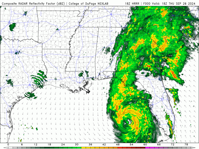
Im hoping to stay in that sweet spot in north AL and not get 5-6"+ of rain. I like the look of the HRRR. NAM is a little closer with the higher totals.
 1
1

Posted on 9/26/24 at 3:44 pm to The Boat
This shows closed-off center well even though it is used as a nighttime image by the pros.


Posted on 9/26/24 at 3:44 pm to stout
quote:
Its not even the happy hour run
I didn't get that joke because I'm super serious in these threads.

Posted on 9/26/24 at 3:44 pm to stout
quote:
As of now, the GFS run for that one shows it smashing SWLA
That can't be accurate, there were people in this thread saying we were done
Posted on 9/26/24 at 3:45 pm to Weekend Warrior79
When in doubt blame that Bama poster that said where are all the hurricanes about a month ago

Posted on 9/26/24 at 3:46 pm to Roll Tide Ravens
quote:
Suspicious cell south of Sarasota. Riding the coastline. Might get a tornado warning out of it.
Tornado warned now.

Posted on 9/26/24 at 3:47 pm to stout
quote:
As of now, the GFS run for that one shows it smashing SWLA
Oh crap
Posted on 9/26/24 at 3:47 pm to Roll Tide Ravens
That warning west of Carabelle is probably on the ground.
Posted on 9/26/24 at 3:48 pm to Roll Tide Ravens
4:00 PM CDT Advisory

BULLETIN
Hurricane Helene Advisory Number 14
NWS National Hurricane Center Miami FL AL092024
500 PM EDT Thu Sep 26 2024
...HELENE IS A VERY DANGEROUS AND LARGE MAJOR HURRICANE...
...DAMAGING HURRICANE WINDS AND CATASTROPHIC STORM SURGE
EXPECTED TO BEGIN IN THE FLORIDA BIG BEND THIS EVENING...
SUMMARY OF 500 PM EDT...2100 UTC...INFORMATION
----------------------------------------------
LOCATION...27.9N 84.6W
ABOUT 130 MI...205 KM W OF TAMPA FLORIDA
ABOUT 175 MI...280 KM S OF TALLAHASSEE FLORIDA
MAXIMUM SUSTAINED WINDS...125 MPH...205 KM/H
PRESENT MOVEMENT...NNE OR 25 DEGREES AT 23 MPH...37 KM/H
MINIMUM CENTRAL PRESSURE...951 MB...28.09 INCHES
This post was edited on 9/26/24 at 3:51 pm
Posted on 9/26/24 at 3:49 pm to LegendInMyMind
The area of N Alabama I'm is is going to take a beating rain wise.
Posted on 9/26/24 at 3:49 pm to Roll Tide Ravens
Helene has rapidly intensified today while nearing landfall in the
Florida Big Bend. Doppler radar and aircraft data indicate that the
eyewall is now completely closed and the eye has become more
circular and is clearing out. The aircraft data also indicated
that the inner core has contracted significantly today while the
tropical-storm-force winds have expanded. Based on all of the data,
the initial intensity is set at 110 kt. The latest minimum pressure
based on the aircraft data is around 951 mb. Tropical-storm-force
winds are occurring across portions of west-central and southwestern
Florida, and conditions are expected to deteriorate rapidly in the
hurricane warning area during the next several hours. It should be
emphasized that Helene is at the upper bound of hurricanes in
terms of storm size and impacts are and will occur well away
from the center.

Posted on 9/26/24 at 3:49 pm to Roll Tide Ravens
Damn.....were right in the middle of the path here in South Georgia. Got everything battened down and hoping for the best. God bless you all for this informative thread and keeping us all informed.
Posted on 9/26/24 at 3:50 pm to Roll Tide Ravens
Thx for the disco in the post.
Posted on 9/26/24 at 3:50 pm to Roll Tide Ravens
Moving 75 mph - how the hell do you handle that??
quote:
444 PM EDT Thu Sep 26 2024
...A TORNADO WARNING REMAINS IN EFFECT UNTIL 515 PM EDT FOR
NORTHWESTERN CHARLOTTE AND SOUTHEASTERN SARASOTA COUNTIES...
At 444 PM EDT, a severe thunderstorm capable of producing a tornado
was located 10 miles west of North Port, moving north at 75 mph.
Posted on 9/26/24 at 3:51 pm to LSUlefty
Look at this one in the northern Atlantic headed to Europe. 


Posted on 9/26/24 at 3:51 pm to Roll Tide Ravens
18Z ICON shows strengthening and a jog east

Posted on 9/26/24 at 3:52 pm to stout
Since it is moving so quickly, will the northland turn take longer? It still has a NE track, but is forecast to turn due north. Would that be delayed by the momentum, pushing the path a little east?
Posted on 9/26/24 at 3:53 pm to Tiger in NY
quote:
Would that be delayed by the momentum, pushing the path a little east?
Its at the mercy of the stuff steering it. If it goes farther east, the cutoff low is pushing it a little farther that way.
Posted on 9/26/24 at 3:54 pm to stout
quote:
and a jog east
we been knowing that from 1 pm advisory
Posted on 9/26/24 at 3:55 pm to Chad504boy
quote:
we been knowing that from 1 pm advisory
Sorry. I took a nap at 1pm so I missed it

 Page 170 of 310

Popular
Back to top